

more stats
2,467 ft
Distance
165 ft
Climb
-5 ft
Descent
00:06:25
Avg time
162 ft
Altitude change
3,074 ft
Altitude min
3,236 ft
Altitude max
3,074 ft
Altitude start
3,235 ft
Altitude end
6.6%
Grade
-4.6%
Grade max
32.9%
Grade min
1,526 ft
Distance climb
453 ft
Distance down
489 ft
Distance flat
00:06:25
Avg time

Upgartner Trail Details

  • Activities
    • Mountain Bike
    • E-Bike
  • Riding Area
  • Ref Number
    T20
  • Difficulty Rating
  • Local Popularity
    95 in Mountain Biking [+]
    • 95 in E-Biking
  • Global Ranking
    #45225 in Mountain Biking [+]
    • #248566 in E-Biking
  • National Ranking
    #395 in Mountain Biking · Austria [+]
    • #808 in E-Biking
  • Trail Type
    Singletrack
  • Bike Type
    AM, XC
  • Direction
    Uphill Only
    Popular Direction Shown
  • Climb Difficulty
    Green
  • Physical Rating
    Easy
  • Trail Visibility
    Always easy to follow
  • Family Friendly
    Yes
  • eBike Allowed
  • TTFs on Trail
    Berm
  • Land Owner
    lake.bike

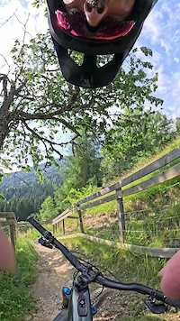
The Upgartner Trail T20 is a specially created mountain bike uphill trail in the Trailcenter Faaker See.

Here, especially families and eBikers have an easy variant to ride up the mountain. Accompanied by waves and fun turns over meadows and through forests, riding uphill is twice as much fun

Access Info

From the start of the trail, always follow the signs Upgartner Trail T20 to the end of the trail.

Tags
BermsFamily friendlyMeadow

Recent Activity on Trail

Past Week
  • 1 rides
  • 14 miles average
6 Months
  • 77 rides
  • 17 miles avg distance
All
  • 289 rides
  • Last: Oct 31, 2026
update trails status or condition

Upgartner Trail Trail Reports

statusdatedescription
Aug 1, 2026 @ 8:24pm (Europe/Vienna)
Aug 1, 2026
top uphill trail, running super good
Mar 31, 2026 @ 7:37pm (Europe/Vienna)
Mar 31, 2026
reporter Season opening 01.04.2026
Nov 9, 2025 @ 6:39pm (Europe/Vienna)
Nov 9, 2025
reporter Season ist over. See you 2026.
Oct 6, 2025 @ 9:46am (Europe/Vienna)
Oct 6, 2025
Apr 22, 2025 @ 10:48pm
Apr 22, 2025
Achtung: Ab 01.05.2025 sind die Trails kostenpflichtig. Ein Trailticket muss gekauft werden. Attention: From 01.05.2025 the trails are subject to...
more »
Status:
on Aug 1, 2026
Ideal
Avg: 4.43 (10 votes)
Your vote: 0

view (2,043)
close
      Directions to upgartner-trail trailhead (46.536410, 13.906230)

      Photos

      2 more »
      mtb
      95 |
      Oct 14, 2024 @ 6:00am
      Oct 14, 2024
      mtb
      208 |
      Jul 24, 2023 @ 1:44am
      Jul 24, 2023

      Videos

      1 more »
      Upgartner Trail
      mtb
      0:23 | 11 | Jun 30, 2026 , Villach

      Routes with this trail

      29 miles • 5,894 ft • 27 • Loop • Race •
      Route of the Austrian Enduro Championship 2026
      4.7 ★★★★★
      10 Ratings
      5 ★ 80%
      4 ★ 10%
      3 ★ 10%
      2 ★
      1 ★

      1 Review & Comments

      crisotop crisotop
      Spitze angelegt, Kurven schön in den Hang gebuddelt, um nicht bei jeder Kehre auch noch am Limit bergauffahren zu müssen. Da können sich viele uphills in Österreich was anschauen Wink

      We hope you've been enjoying Trailforks!

      Create a FREE account to view all trail reviews and much more.

      • By lakebiketrailsTF Pro lakebike & contributors
      • #667439 - 656 views

      Frequently Asked Questions

      ▼ Where is Upgartner Trail located?
      Upgartner Trail is located in Trailcenter Faaker See, Villach, Austria. It is part of the Trailcenter Faaker See trail network. The trailhead is located at coordinates 46.53641, 13.90623.
      ▼ How hard is Upgartner Trail?
      Upgartner Trail is rated as Blue difficulty. The physical rating is Easy. The average grade is 6.6%. The climb difficulty is rated Green.
      ▼ What is the elevation gain for Upgartner Trail?
      Upgartner Trail has 165 ft of elevation gain. The trail has 5 ft of elevation descent. The elevation ranges from 3,074 ft to 3,236 ft.
      ▼ Is Upgartner Trail a point to point trail?
      Yes, Upgartner Trail is a point to point trail. The direction is Uphill Only. The trail type is singletrack.
      ▼ How long is Upgartner Trail?
      Upgartner Trail is 2,467 ft long. The trail type is singletrack.
      ▼ Are dogs allowed on Upgartner Trail?
      There is no information about dogs being allowed on Upgartner Trail. Check with local trail managers or the trail page for the latest access rules.
      ▼ How do I access Upgartner Trail? Where is the closest parking trailhead?
      The closest parking and trailhead locations to Upgartner Trail are: View all parking locations in the area.
      ▼ How long does it take to ride Upgartner Trail?
      Based on recorded activities, it takes an average of 6 minutes to ride Upgartner Trail. The trail is 2,467 ft long. Actual times will vary based on fitness level, conditions, and pace. View recent activity logs for more details.
      ▼ How busy is Upgartner Trail?
      Upgartner Trail is a very popular trail. There have been 970 recorded activities on this trail. The trail has received 2,043 check-ins. View recent activity on this trail.

      Hit the Trail

      Open in App

      Get this trail on your phone instantly.

      open trail in app

      Download Trail

      Save to wishlist, Garmin & download.
      save the trail

      Find Related Routes

      Find routes and users activities that include this trail.
      find routes for this trail

      You must enter a description before submitting.

