more stats
2,051 ft
Distance
-641 ft
Descent
00:06:09
Avg time
-641 ft
Altitude change
2,606 ft
Altitude min
3,247 ft
Altitude max
3,247 ft
Altitude start
2,605 ft
Altitude end
-31.3%
Grade
-50.4%
Grade max
-13.7%
Grade min
2,051 ft
Distance down
00:06:09
Avg time

Upper Boondocker Details

  • Activities
    • Mountain Bike
    • E-Bike
  • Riding Area
    Boulder Mountain
    Revelstoke, British Columbia
  • Difficulty Rating
  • Voted Difficulty
    Black Diamond (2 votes)
  • Local Popularity
    90 in Mountain Biking [+]
    • 95 in E-Biking
  • Global Ranking
    #27832 in Mountain Biking [+]
    • #14961 in E-Biking
  • Trail Type
    Singletrack
  • Bike Type
    DH, AM
  • Direction
    Downhill Only
    Popular Direction Shown
  • Dogs Allowed
    Yes
  • eBike Allowed
    Yes up to Class 1
  • TTFs on Trail
    Jump

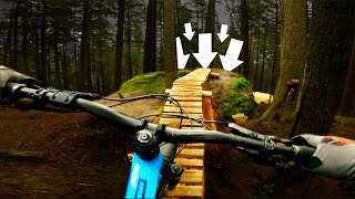
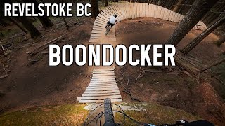
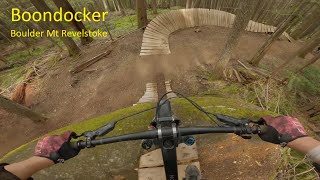
Fast, steep, rooty, & loose
Steeper than the lower part of Boondocker.

Note: Hot Dog Hallway was rebuilt in October 2024. Please ride slowly your first time down until you're comfortable with the new line.

Trail Supporters
  • Revelstoke suspension Services
    since 2023
    Sponsor
Local Trail Association

Recent Activity on Trail

Past Week
  • 11 rides
  • 10 miles average
6 Months
  • 23 rides
  • 10 miles avg distance
All
  • 331 rides
  • Last: Jul 2, 2026
c1c2c3c4
January
February
March
April
May
June
July
August
September
October
November
December
update trails status or condition

Upper Boondocker Trail Reports

statusdatedescription
Jul 1, 2026 @ 10:58pm (America/Vancouver)
19 hours
What a dh trail should be jank with the options for big pulls gets rowdy
Jun 29, 2026 @ 3:01pm (America/Creston)
Jun 29, 2026
reporter
May 17, 2026 @ 9:13pm (America/Vancouver)
May 17, 2026
Snow covering 100m of the road. Trail riding great
May 10, 2026 @ 8:33pm (America/Vancouver)
May 10, 2026
No snow on trail. But snow on the fsr to get to the trail. Early season and lots of debris and one down log.
Dec 24, 2025 @ 1:42pm (America/Vancouver)
Dec 24, 2025
reporter All trails on Boulder are closed for winter
more »
Status:
on Jul 1, 2026
Avg: 4.67 (32 votes)
Your vote: 0

view (2,602)
close
3D
Trail Conditions
  • Unknown
  • Snow Groomed
  • Snow Packed
  • Snow Covered
  • Snow Cover Partial
  • Freeze/thaw Cycle
  • Icy
  • Prevalent Mud
  • Wet
  • Variable
  • Ideal
  • Dry
  • Very Dry
Trail Flow (Ridden Direction)
Trailforks scans users ridelogs to determine the most popular direction each trail is ridden. A good flowing trail network will have most trails flowing in a single direction according to their intension.
The colour categories are based on what percentage of riders are riding a trail in its intended direction.
  • > 96%
  • > 90%
  • > 80%
  • > 70%
  • > 50%
  • < 50%
  • bi-directional trail
  • no data
Trail Last Ridden
Trailforks scans ridelogs to determine the last time a trail was ridden.
  • < 2 days
  • < 1 week
  • < 2 weeks
  • < 1 month
  • < 6 months
  • > 6 months
Trail Ridden Direction
The intended direction a trail should be ridden.
  • Downhill Only
  • Downhill Primary
  • Both Directions
  • Uphill Primary
  • Uphill Only
  • One Direction
Contribute Details
Colors indicate trail is missing specified detail.
  • Description
  • Photos
  • Description & Photos
  • Videos
Trail Popularity ?
Trailforks scans ridelogs to determine which trails are ridden the most in the last 9 months. Trails are compared with nearby trails in the same city region with a possible 25 colour shades. Think of this as a heatmap, more rides = more kinetic energy = warmer colors.
  • most popular
  • popular
  • less popular
  • not popular
ATV/ORV/OHV Filter
Max Vehicle Width
inches
US Cell Coverage
Legend
cell carrier legend

Radar Time
Activity Recordings
Trailforks uses anonymized public activity data. ?
Activity Recordings
Trailforks uses anonymized public activity data. ?
Personal Heatmap
Activity Types
all / none
Options
2
Date range month
Winter Trails
Warning A routing network for winter maps does not exist. Selecting trails using the winter trails layer has been disabled.
Missing Trails
Most Popular
Least Popular
Trails are colored based on popularity. The more popular a trail is, the more red. Less popular trails trend towards green.
Jump Magnitude Heatmap
Heatmap of where riders jump on trails. Zoom in to see individual jumps, click circles to view jump details.
BC Backroad Status

Service Road Atlas is a free to use, community-driven service for viewing and creating reports on the numerous back-country service roads around B.C. and Alberta.

map legend
Slope Aspect
Direction the slope faces
Flat N NE E SE S SW W NW
Trails Deemphasized
Trails are shown in grey.
disable
Only show trails with no bike usage.
Enable
Suggested Layers
Based on selected activity type

    Save the current map location and zoom level as your default home location whenever this page is loaded.

    Save
        Directions to upper-boondocker trailhead (51.016520, -118.267780)

        Photos

        11 more »
        99 |
        Jun 20, 2024 @ 9:55pm
        Jun 20, 2024
        165 |
        Jun 2, 2022 @ 3:02pm
        Jun 2, 2022
        314 |
        Aug 22, 2020 @ 7:20am
        Aug 22, 2020
        442 |
        Aug 22, 2020 @ 7:20am
        Aug 22, 2020

        Videos

        8 more »
        youtuber Racing as a TEAM?!?!//Canadian Enduro League -...
        13:33 | 199 | Apr 5, 2024 , Revelstoke
        youtuber RYAN'S DREAM TRAIL // 'Boondocker' leaves me...
        11:20 | 808 | Nov 29, 2020 , Revelstoke
        youtuber Boondocker - Revelstoke MTB
        7:29 | 299 | Aug 2, 2023 , Revelstoke
        Boondocker (Boulder Mountain Revelstoke BC)
        8:28 | 399 | Jun 22, 2022 , Revelstoke

        Routes with this trail

        18 miles 4,949 ft 9
        No Shuttling on Boulder!!!!! Short Course Day 2 - stages 4,6,7
        39 miles 11,611 ft 22 Loop
        Route aimed at riding all trails on trail forks. I started from the Big Eddy Side, into logging left...
        4.0 25 miles 6,255 ft 47 Loop Race
        STAGE ORDER (This is the Sequence Which You Will Ride The Stages In) U21 and U15 = 1,2,3,4 21-29 Men =...

        4 Reviews & Comments


        We hope you've been enjoying Trailforks!

        Create a FREE account to view trail comments and much more.

        • By canadakaTF Pro Trailforks & contributors
        • #31925 - 6,349 views

        Frequently Asked Questions About Upper Boondocker

        Where is Upper Boondocker located?
        Upper Boondocker is located in Boulder Mountain, Revelstoke, British Columbia, Canada. It is part of the Boulder Mountain trail network. The trailhead is located at coordinates 51.01652, -118.26778.
        How hard is Upper Boondocker?
        Upper Boondocker is rated as Black Diamond difficulty. The average grade is 31.3%.
        What is the elevation gain for Upper Boondocker?
        The trail has 641 ft of elevation descent. The elevation ranges from 2,606 ft to 3,247 ft.
        Is Upper Boondocker a point to point trail?
        Yes, Upper Boondocker is a point to point trail. The direction is Downhill Only. The trail type is singletrack.

        Hit the Trail

        Open in App

        Get this trail on your phone instantly.
        open trail in app

        Download Trail

        Save to wishlist, Garmin & download.
        save the trail

        Find Related Routes

        Find routes and users activities that include this trail.
        find routes for this trail

        You must enter a description before submitting.