more stats
1.4 miles
Distance
7 ft
Climb
-641 ft
Descent
00:23:57
Avg time
-634 ft
Altitude change
1,643 ft
Altitude min
2,278 ft
Altitude max
2,278 ft
Altitude start
1,644 ft
Altitude end
-8.7%
Grade
-29%
Grade max
5.3%
Grade min
325 ft
Distance climb
1 mile
Distance down
1,099 ft
Distance flat
00:23:57
Avg time

Upper Thunderstruck Details

  • Activities
    • Mountain Bike
    • E-Bike
  • Riding Area
    Cacapon Resort State Park
    Berkeley Springs, West Virginia
  • Difficulty Rating
  • Voted Difficulty
    Black Diamond (2 votes)
  • Local Popularity
    60 in Mountain Biking [+]
    • 55 in E-Biking
  • Global Ranking
    #23819 in Mountain Biking [+]
    • #76329 in E-Biking
  • Trail Type
    Singletrack
  • Bike Type
    DH, AM, XC
  • Physical Rating
    Moderate
  • Trail Visibility
    Always easy to follow
  • eBike Allowed
    Yes up to Class 1
  • TTFs on Trail
    Drop, Jump, Gap Jump, Rock Garden
  • Lighting
    No
  • Land Owner
    West Virginia State Park

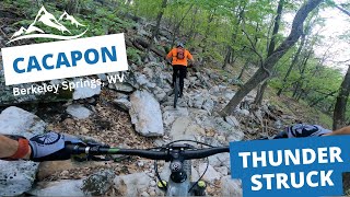
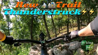
A new trail added in 2022. Accessed from the lookout. No bail outs until the blue lower section and the trail is very rocky. If the very start of the trail intimidates you, I would suggest riding something else. Tons of fun if you enjoy a chunkier downhill trail.

Local Trail Association
Traditionally Indigenous Territory

Recent Activity on Trail

Past Week
  • 0 rides
  •  
6 Months
  • 25 rides
  • 17 miles avg distance
All
  • 131 rides
  • Last: Jun 24, 2026
c1c2c3c4
January
February
March
April
May
June
July
August
September
October
November
December
update trails status or condition

Upper Thunderstruck Trail Reports

statusdatedescription
Jun 22, 2026 @ 6:57am (America/New_York)
Jun 22, 2026
Tree still down, with no clear passage.
May 11, 2026 @ 12:10pm (America/New_York)
May 11, 2026
Tree down about 50/100 yards from the start.
Oct 2, 2025 @ 9:19am (America/New_York)
Oct 2, 2025
Jul 19, 2025 @ 9:37am
Jul 19, 2025
Slick and very overgrown. Would avoid until weeds are cut
Sep 15, 2024 @ 9:01am
Sep 15, 2024
more »
Status:
on Jun 22, 2026
Variable
Avg: 4.07 (7 votes)
Your vote: 0

view (814)
close
3D
Trail Conditions
  • Unknown
  • Snow Groomed
  • Snow Packed
  • Snow Covered
  • Snow Cover Partial
  • Freeze/thaw Cycle
  • Icy
  • Prevalent Mud
  • Wet
  • Variable
  • Ideal
  • Dry
  • Very Dry
Trail Flow (Ridden Direction)
Trailforks scans users ridelogs to determine the most popular direction each trail is ridden. A good flowing trail network will have most trails flowing in a single direction according to their intension.
The colour categories are based on what percentage of riders are riding a trail in its intended direction.
  • > 96%
  • > 90%
  • > 80%
  • > 70%
  • > 50%
  • < 50%
  • bi-directional trail
  • no data
Trail Last Ridden
Trailforks scans ridelogs to determine the last time a trail was ridden.
  • < 2 days
  • < 1 week
  • < 2 weeks
  • < 1 month
  • < 6 months
  • > 6 months
Trail Ridden Direction
The intended direction a trail should be ridden.
  • Downhill Only
  • Downhill Primary
  • Both Directions
  • Uphill Primary
  • Uphill Only
  • One Direction
Contribute Details
Colors indicate trail is missing specified detail.
  • Description
  • Photos
  • Description & Photos
  • Videos
Trail Popularity ?
Trailforks scans ridelogs to determine which trails are ridden the most in the last 9 months. Trails are compared with nearby trails in the same city region with a possible 25 colour shades. Think of this as a heatmap, more rides = more kinetic energy = warmer colors.
  • most popular
  • popular
  • less popular
  • not popular
ATV/ORV/OHV Filter
Max Vehicle Width
inches
US Cell Coverage
Legend
cell carrier legend

Radar Time
Activity Recordings
Trailforks uses anonymized public activity data. ?
Activity Recordings
Trailforks uses anonymized public activity data. ?
Personal Heatmap
Activity Types
all / none
Options
2
Date range month
Winter Trails
Warning A routing network for winter maps does not exist. Selecting trails using the winter trails layer has been disabled.
Missing Trails
Most Popular
Least Popular
Trails are colored based on popularity. The more popular a trail is, the more red. Less popular trails trend towards green.
Jump Magnitude Heatmap
Heatmap of where riders jump on trails. Zoom in to see individual jumps, click circles to view jump details.
BC Backroad Status

Service Road Atlas is a free to use, community-driven service for viewing and creating reports on the numerous back-country service roads around B.C. and Alberta.

map legend
Slope Aspect
Direction the slope faces
Flat N NE E SE S SW W NW
Trails Deemphasized
Trails are shown in grey.
disable
Only show trails with no bike usage.
Enable
Suggested Layers
Based on selected activity type

    Save the current map location and zoom level as your default home location whenever this page is loaded.

    Save
        Directions to upper-thunderstruck trailhead (39.470520, -78.344150)

        Photos

        12 more »
        3 |
        Jun 28, 2026 @ 4:12am
        2 days
        3 |
        Jun 28, 2026 @ 4:11am
        2 days
        292 |
        Aug 29, 2023 @ 12:07pm
        Aug 29, 2023
        317 |
        Aug 29, 2023 @ 12:07pm
        Aug 29, 2023

        Videos

        7 more »
        Probably not doing this again: 2024 Cacapon Enduro
        29:48 | 104 | Oct 25, 2024 , Berkeley Springs
        Many Rocks Were Harmed in the Making of this...
        16:31 | 404 | Sep 6, 2023 , Berkeley Springs
        Thunderstruck Upper at Capacon State Park
        11:00 | 437 | Mar 22, 2023 , Berkeley Springs
        Biking Bad - Mountain Biking New Trail at...
        18:34 | 875 | Oct 10, 2022 , Berkeley Springs

        Routes with this trail

        1.0 14 miles 2,793 ft 5
        Twin loop of Cacapon , 14 miles including all of Thunderstruck and parts of ziler.

        6 Reviews & Comments


        We hope you've been enjoying Trailforks!

        Create a FREE account to view trail comments and much more.

        Frequently Asked Questions About Upper Thunderstruck

        Where is Upper Thunderstruck located?
        Upper Thunderstruck is located in Cacapon Resort State Park, Berkeley Springs, West Virginia, United States. It is part of the Cacapon Resort State Park trail network. The trailhead is located at coordinates 39.47052, -78.34415.
        How hard is Upper Thunderstruck?
        Upper Thunderstruck is rated as Black Diamond difficulty. The physical rating is Moderate. The average grade is 8.7%.
        What is the elevation gain for Upper Thunderstruck?
        Upper Thunderstruck has 7 ft of elevation gain. The trail has 641 ft of elevation descent. The elevation ranges from 1,643 ft to 2,278 ft.
        How long is Upper Thunderstruck?
        Upper Thunderstruck is 1.4 miles long. The trail type is singletrack.

        Hit the Trail

        Open in App

        Get this trail on your phone instantly.
        open trail in app

        Download Trail

        Save to wishlist, Garmin & download.
        save the trail

        Find Related Routes

        Find routes and users activities that include this trail.
        find routes for this trail

        You must enter a description before submitting.