Supporters, Builders, Maintainers & Land Managers of Upper Timberline Trail
USFSLand Manager
Upper Timberline Details
-
Activities
- Mountain Bike
-
Riding AreaBrian Head Resort
Brian Head, Utah -
Difficulty Rating
-
Voted DifficultyBlue (1 vote)
-
Trail TypeSingletrack
-
Bike TypeDH, AM
-
DirectionDownhill OnlyPopular direction shown
-
Global Ranking#8197 in Mountain Biking
-
Local Popularity80 in Mountain Biking
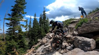
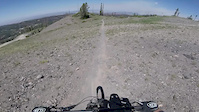
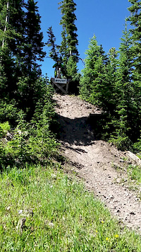
This upper section starts off with a bit of a slow climb. This trail is a bit more primitive than the others, as it requires you to climb some at the start. The trail is also a bit more narrow than the typical resort trail, but is rocky and fun without really being all that difficult. A lot of riders opt to skip this upper section, and ride a bit down the road where they hook up with the main Timberline Downhill Trail.
Bike Park
Traditionally Indigenous Territory
More Stats for Upper Timberline mountain bike trail trail
-
Altitude change-108 ft
-
Altitude min10,769 ft
-
Altitude max10,882 ft
-
Altitude start10,877 ft
-
Altitude end10,768 ft
-
Grade-3.3%
-
Grade max-17.7%
-
Grade min2.8%
-
Distance climb423 ft
-
Distance down2,405 ft
-
Distance flat430 ft
-
Avg time00:05:21
-
Avg reverse time00:05:09
- view trail stats
-
Layers w
- Map Content
- More Layers
- Pro
- Pro
- Pro
- Pro
- Pro
- Pro
- Pro
- Pro
-
Upgrade to

- Unknown
- Snow Groomed
- Snow Packed
- Snow Covered
- Snow Cover Partial
- Freeze/thaw Cycle
- Icy
- Prevalent Mud
- Wet
- Variable
- Ideal
- Dry
- Very Dry
The colour categories are based on what percentage of riders are riding a trail in its intended direction.
- > 96%
- > 90%
- > 80%
- > 70%
- > 50%
- < 50%
- bi-directional trail
- no data
- < 2 days
- < 1 week
- < 2 weeks
- < 1 month
- < 6 months
- > 6 months
- Downhill Only
- Downhill Primary
- Both Directions
- Uphill Primary
- Uphill Only
- One Direction
- Description
- Photos
- Description & Photos
- Videos
- most popular
- popular
- less popular
- not popular

- mountain biking recent
- mountain biking (>6 month)
- hiking (1 year)
- moto (1 year)
- Downhill Ski
- Backcountry Ski
- Nordic Ski
- Snowmobile
Save the current map location and zoom level as your default home location whenever this page is loaded.
SaveUpper Timberline Trail Reports
Recent Ridelog Activity on Trail
- 0 rides
- 0 rides
- 968 rides
- Last: Sep 22, 2023
Photos
Routes with this trail
Reviews / Comments
No reviews yet, be the first to write a review or ask a question.
Use trail reports to comment on trail conditions.
We hope you've been enjoying Trailforks!
Create a FREE account to view trail comments and much more.
Videos

Nearby Trails
- Sunburst 404 ft
- Giant Steps 453 ft
- Hunter's Run 499 ft
- Color Flow 587 ft
- Little Glitter 587 ft
- By todd
 Trailforks & contributors
 - #11790 - 1,782 views
You must enter a description before submitting.