more stats
2,785 ft
Distance
-176 ft
Descent
785 ft
High Point
-176 ft
Altitude change
608 ft
Altitude min
784 ft
Altitude start
607 ft
Altitude end
-6.3%
Grade
-23.9%
Grade max
1.8%
Grade min
112 ft
Distance climb
2,270 ft
Distance down
404 ft
Distance flat

Vegeta Details

  • Activities
    • Mountain Bike
    • E-Bike
    • Hike
    • Trail Running
  • Riding Area
    La Plana Alta
    Vilanova D'Alcolea
  • Difficulty Rating
  • Local Popularity
    95 in Mountain Biking [+]
    • 95 in E-Biking
    • 5 in Trail Running
    • 5 in Hiking
  • Global Ranking
    #6914 in Mountain Biking [+]
    • #19568 in E-Biking
    • #214033 in Trail Running
    • #218148 in Hiking
  • Hiking SAC Scale
    T3 Demanding Mountain Hiking
  • Trail Type
    Singletrack
  • Bike Type
    AM, XC
  • Direction
    Downhill Primary
    Popular Direction Shown
  • Climb Difficulty
    Black Diamond
  • Physical Rating
    Moderate
  • Trail Visibility
    Always easy to follow
  • Dogs Allowed
    Yes
  • eBike Allowed
    Yes up to Class 1

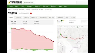
Senda de muchos toboganes fáciles de bajada y alguna rampa de subida larga y divertida. Hay que estar pendiente de no perderse en alguna salida de toboganes. La salida final al camino es la que tiene más pendiente y hay que ir con más cuidado.

Local Trail Association

Recent Activity on Trail

Past Week
  • 0 rides
  •  
6 Months
  • 7 rides
  • 17 miles avg distance
All
  • 51 rides
  • Last: May 17, 2026
c1c2c3c4
January
February
March
April
May
June
July
August
September
October
November
December
Status:
on Jun 27, 2026
Ideal
Avg: 4.13 (1 votes)
Your vote: 0

view (210)
close
3D
Trail Conditions
  • Unknown
  • Snow Groomed
  • Snow Packed
  • Snow Covered
  • Snow Cover Partial
  • Freeze/thaw Cycle
  • Icy
  • Prevalent Mud
  • Wet
  • Variable
  • Ideal
  • Dry
  • Very Dry
Trail Flow (Ridden Direction)
Trailforks scans users ridelogs to determine the most popular direction each trail is ridden. A good flowing trail network will have most trails flowing in a single direction according to their intension.
The colour categories are based on what percentage of riders are riding a trail in its intended direction.
  • > 96%
  • > 90%
  • > 80%
  • > 70%
  • > 50%
  • < 50%
  • bi-directional trail
  • no data
Trail Last Ridden
Trailforks scans ridelogs to determine the last time a trail was ridden.
  • < 2 days
  • < 1 week
  • < 2 weeks
  • < 1 month
  • < 6 months
  • > 6 months
Trail Ridden Direction
The intended direction a trail should be ridden.
  • Downhill Only
  • Downhill Primary
  • Both Directions
  • Uphill Primary
  • Uphill Only
  • One Direction
Contribute Details
Colors indicate trail is missing specified detail.
  • Description
  • Photos
  • Description & Photos
  • Videos
Trail Popularity ?
Trailforks scans ridelogs to determine which trails are ridden the most in the last 9 months. Trails are compared with nearby trails in the same city region with a possible 25 colour shades. Think of this as a heatmap, more rides = more kinetic energy = warmer colors.
  • most popular
  • popular
  • less popular
  • not popular
ATV/ORV/OHV Filter
Max Vehicle Width
inches
US Cell Coverage
Legend
cell carrier legend

Radar Time
Activity Recordings
Trailforks uses anonymized public activity data. ?
Activity Recordings
Trailforks uses anonymized public activity data. ?
Personal Heatmap
Activity Types
all / none
Options
2
Date range month
Winter Trails
Warning A routing network for winter maps does not exist. Selecting trails using the winter trails layer has been disabled.
Missing Trails
Most Popular
Least Popular
Trails are colored based on popularity. The more popular a trail is, the more red. Less popular trails trend towards green.
Jump Magnitude Heatmap
Heatmap of where riders jump on trails. Zoom in to see individual jumps, click circles to view jump details.
BC Backroad Status

Service Road Atlas is a free to use, community-driven service for viewing and creating reports on the numerous back-country service roads around B.C. and Alberta.

map legend
Slope Aspect
Direction the slope faces
Flat N NE E SE S SW W NW
Trails Deemphasized
Trails are shown in grey.
disable
Only show trails with no bike usage.
Enable
Suggested Layers
Based on selected activity type

    Save the current map location and zoom level as your default home location whenever this page is loaded.

    Save
        Directions to vegeta trailhead (40.278570, 0.130780)

        Photos

        No photos have been added for Vegeta yet, add a photo.

        Videos

        5 more »
        Senda Vegeta 4k les coves
        3:02 | 33 | Jul 18, 2025 , Vilanova D'Alcolea
        Vegeta 4k
        3:55 | 19 | Mar 28, 2025 , Vilanova D'Alcolea
        Vegeta
        6:33 | 48 | Nov 14, 2024 , Vilanova D'Alcolea
        SENDA VEGETA
        4:08 | 12 | Dec 25, 2024 , Vilanova D'Alcolea

        Routes with this trail

        5.0 13 miles 1,880 ft 11 Loop
        La ruta DRAGON BALL empieza en Coves de Vinroma es de unos 21 km de largo con unos 575 metros de desnivel...
        5.0 25 miles 3,741 ft 28 Loop
        Ruta con punto de partida en Les Coves de Vinroma , muy parecida a una ya existente llamada el tour dels...
        36 miles 5,256 ft 40 Out & Back
        La Ruta El Tour dels Tobogans es una ruta que comienza en Coves de Vinroma se divide en 3 etapas en las...

        Reviews / Comments

        No reviews yet, be the first to write a review or ask a question.
        Use trail reports to comment on trail conditions.


        We hope you've been enjoying Trailforks!

        Create a FREE account to view trail comments and much more.

        • By olecovesTF Pro & contributors
        • #798077 - 306 views

        Frequently Asked Questions About Vegeta

        Where is Vegeta located?
        Vegeta is located in La Plana Alta, Vilanova D'Alcolea, Spain. It is part of the La Plana Alta trail network. The trailhead is located at coordinates 40.27857, 0.13078.
        How hard is Vegeta?
        Vegeta is rated as Blue difficulty. The physical rating is Moderate. The average grade is 6.3%. The climb difficulty is rated Black Diamond.
        What is the elevation gain for Vegeta?
        The trail has 54 m of elevation descent. The elevation ranges from 185 m to 239 m.
        Is Vegeta a point to point trail?
        Vegeta is not a point to point trail. The direction is Downhill Primary. The trail type is singletrack.

        Hit the Trail

        Open in App

        Get this trail on your phone instantly.
        open trail in app

        Download Trail

        Save to wishlist, Garmin & download.
        save the trail

        Find Related Routes

        Find routes and users activities that include this trail.
        find routes for this trail

        You must enter a description before submitting.