more stats
2,198 ft
Distance
11 ft
Climb
-102 ft
Descent
00:04:38
Avg time
-90 ft
Altitude change
9,623 ft
Altitude min
9,725 ft
Altitude max
9,725 ft
Altitude start
9,636 ft
Altitude end
-4.1%
Grade
-25%
Grade max
7.7%
Grade min
423 ft
Distance climb
1,709 ft
Distance down
66 ft
Distance flat
00:04:38
Avg time

Verbena Details

  • Activities
    • Mountain Bike
    • E-Bike
    • Winter Fat Bike
    • Hike
    • Trail Running
  • Riding Area
    Parque Ejidal San Nicolás Totolapan
    San Nicolás Totolapan
  • Difficulty Rating
  • Local Popularity
    95 in Mountain Biking [+]
    • 95 in E-Biking
    • 95 in Trail Running
    • 100 in Hiking
  • Global Ranking
    #45465 in Mountain Biking [+]
    • #16347 in E-Biking
    • #21754 in Trail Running
    • #5065 in Hiking
  • Hiking SAC Scale
    T2 Mountain Hiking
  • Trail Type
    Doubletrack
  • Bike Type
    DH, AM, XC, Fat
  • Direction
    Both Directions
    Popular Direction Shown
  • Climb Difficulty
    Blue
  • Physical Rating
    Moderate
  • Trail Visibility
    Always easy to follow
  • Family Friendly
    Yes
  • Dogs Allowed
    Yes
  • eBike Allowed
    Yes up to Class 1
  • TTFs on Trail
    Bridge, Drop
  • Ride in Rain
    Yes
  • Land Owner
    Ejido San Nicolás Totolapan

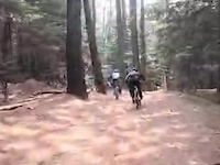
Sendero rápido que corre por toda la orilla de la zona de campamento dese el camino ancho a La Virgen/ hasta Single 1, en ocasiones debe tenerse cuidado con los paseantes y perros.

Access Info

Por el lado Norte del campamento en el acceso al Plan de la maquina, por el sur desde el valle.

Bike Park

Local Trail Association
Traditionally Indigenous Territory

Recent Activity on Trail

Past Week
  • 1 rides
  • 8 miles average
6 Months
  • 34 rides
  • 10 miles avg distance
All
  • 548 rides
  • Last: Jul 4, 2026
c1c2c3c4
January
February
March
April
May
June
July
August
September
October
November
December
Status:
on Jul 12, 2025
Wet
Avg: 3.98 (1 votes)
Your vote: 0

view (2,741)
close
3D
Trail Conditions
  • Unknown
  • Snow Groomed
  • Snow Packed
  • Snow Covered
  • Snow Cover Partial
  • Freeze/thaw Cycle
  • Icy
  • Prevalent Mud
  • Wet
  • Variable
  • Ideal
  • Dry
  • Very Dry
Trail Flow (Ridden Direction)
Trailforks scans users ridelogs to determine the most popular direction each trail is ridden. A good flowing trail network will have most trails flowing in a single direction according to their intension.
The colour categories are based on what percentage of riders are riding a trail in its intended direction.
  • > 96%
  • > 90%
  • > 80%
  • > 70%
  • > 50%
  • < 50%
  • bi-directional trail
  • no data
Trail Last Ridden
Trailforks scans ridelogs to determine the last time a trail was ridden.
  • < 2 days
  • < 1 week
  • < 2 weeks
  • < 1 month
  • < 6 months
  • > 6 months
Trail Ridden Direction
The intended direction a trail should be ridden.
  • Downhill Only
  • Downhill Primary
  • Both Directions
  • Uphill Primary
  • Uphill Only
  • One Direction
Contribute Details
Colors indicate trail is missing specified detail.
  • Description
  • Photos
  • Description & Photos
  • Videos
Trail Popularity ?
Trailforks scans ridelogs to determine which trails are ridden the most in the last 9 months. Trails are compared with nearby trails in the same city region with a possible 25 colour shades. Think of this as a heatmap, more rides = more kinetic energy = warmer colors.
  • most popular
  • popular
  • less popular
  • not popular
ATV/ORV/OHV Filter
Max Vehicle Width
inches
US Cell Coverage
Legend
cell carrier legend

Radar Time
Activity Recordings
Trailforks uses anonymized public activity data. ?
Activity Recordings
Trailforks uses anonymized public activity data. ?
Personal Heatmap
Activity Types
all / none
Options
2
Date range month
Winter Trails
Warning A routing network for winter maps does not exist. Selecting trails using the winter trails layer has been disabled.
Missing Trails
Most Popular
Least Popular
Trails are colored based on popularity. The more popular a trail is, the more red. Less popular trails trend towards green.
Jump Magnitude Heatmap
Heatmap of where riders jump on trails. Zoom in to see individual jumps, click circles to view jump details.
BC Backroad Status

Service Road Atlas is a free to use, community-driven service for viewing and creating reports on the numerous back-country service roads around B.C. and Alberta.

map legend
Slope Aspect
Direction the slope faces
Flat N NE E SE S SW W NW
Trails Deemphasized
Trails are shown in grey.
disable
Only show trails with no bike usage.
Enable
Suggested Layers
Based on selected activity type

    Save the current map location and zoom level as your default home location whenever this page is loaded.

    Save
        Directions to verbena trailhead (19.253250, -99.255920)

        Photos

        11 more »
        19 |
        May 10, 2023 @ 1:42pm
        May 10, 2023
        26 |
        Dec 20, 2022 @ 10:03pm
        Dec 20, 2022
        16 |
        Dec 20, 2022 @ 10:03pm
        Dec 20, 2022
        19 |
        Dec 20, 2022 @ 10:03pm
        Dec 20, 2022

        Videos

        1 more »
        0:45 | 8 | Apr 16, 2025 , San Nicolás Totolapan

        Routes with this trail

        5.0 19 miles 4,560 ft 12 Loop
        Ruta que parte del Parque al 4to dinamo del . La mayoría de lo senderos son fáciles y bastante amplios,...
        7 miles 1,667 ft 6 Loop
        La ruta " - - " ofrece una experiencia única de ciclismo de montaña que combina diversión, técnica y...
        17 miles 2,784 ft 9 Loop
        Ruta iniciando en el Parque Ejidal San Nicolas Totolapan (Las llantas) al 4to Dinamo, pasando por el Valle...

        Reviews / Comments

        No reviews yet, be the first to write a review or ask a question.
        Use trail reports to comment on trail conditions.


        We hope you've been enjoying Trailforks!

        Create a FREE account to view trail comments and much more.

        • By HHermes & contributors
        • #122375 - 1,013 views

        Frequently Asked Questions About Verbena

        Where is Verbena located?
        Verbena is located in Parque Ejidal San Nicolás Totolapan, San Nicolás Totolapan, México. It is part of the Parque Ejidal San Nicolás Totolapan trail network. The trailhead is located at coordinates 19.25325, -99.25592.
        How hard is Verbena?
        Verbena is rated as Blue difficulty. The physical rating is Moderate. The average grade is 4.1%. The climb difficulty is rated Blue.
        What is the elevation gain for Verbena?
        Verbena has 11 ft of elevation gain. The trail has 102 ft of elevation descent. The elevation ranges from 9,623 ft to 9,725 ft.
        Is Verbena a point to point trail?
        Verbena is not a point to point trail. The direction is Both Directions. The trail type is doubletrack.

        Hit the Trail

        Open in App

        Get this trail on your phone instantly.
        open trail in app

        Download Trail

        Save to wishlist, Garmin & download.
        save the trail

        Find Related Routes

        Find routes and users activities that include this trail.
        find routes for this trail

        You must enter a description before submitting.