4.8 miles
Distance
1,558 ft
Climb
-1,822 ft
Descent
02:06:57
Avg time
Supporters, Builders, Maintainers & Land Managers of Wheeler Trail
USFSLand Manager
Wheeler Details
-
Activities
- Mountain Bike
- Hike
- Trail Running
-
Riding AreaBreckenridge
, Colorado -
Difficulty Rating
-
Voted DifficultyDouble Black Diamond (1 vote)
-
Trail TypeSingletrack
-
DirectionBoth DirectionsPopular in reverse
-
Dogs AllowedYes
-
eBike Allowed
-
Global Ranking
-
Local Popularity50 in Mountain Biking [+]
- 5 in Trail Running
- 55 in Hiking
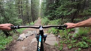
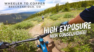
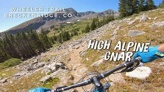
One of the best high alpine trails in the area. Huge views and skinny singletrack are prominent. Best ways to be ridden are climbing the peak 9 rd from Breck and heading either north or south from the intersection with the trail. Can be linked to miner's creek for a truly amazing high alpine experience when heading north from peak 9 rd.
Local Trail Association
-
Please consider joining or donating to the local trail association to supportdonate to earn trail karma!
trail development & maintenance.
Traditionally Indigenous Territory
More Stats for Wheeler mountain bike trail trail
-
Altitude change-264 ft
-
Altitude min10,989 ft
-
Altitude max12,538 ft
-
Altitude start11,253 ft
-
Altitude end10,989 ft
-
Grade-1.036%
-
Grade max-178.756%
-
Grade min278.881%
-
Distance climb3 miles
-
Distance down2 miles
-
Distance flat371 ft
-
Avg time02:06:57
-
Avg reverse time01:32:22
- view trail stats
close
3D
Trail Conditions
- Unknown
- Snow Groomed
- Snow Packed
- Snow Covered
- Snow Cover Partial
- Freeze/thaw Cycle
- Icy
- Prevalent Mud
- Wet
- Variable
- Ideal
- Dry
- Very Dry
Trail Flow (Ridden Direction)
Trailforks scans users ridelogs to determine the most popular direction each trail is ridden. A good flowing trail network will have most trails flowing in a single direction according to their intension.
The colour categories are based on what percentage of riders are riding a trail in its intended direction.
- > 96%
- > 90%
- > 80%
- > 70%
- > 50%
- < 50%
- bi-directional trail
- no data
Trail Last Ridden
Trailforks scans ridelogs to determine the last time a trail was ridden.
- < 2 days
- < 1 week
- < 2 weeks
- < 1 month
- < 6 months
- > 6 months
Trail Ridden Direction
The intended direction a trail should be ridden.
- Downhill Only
- Downhill Primary
- Both Directions
- Uphill Primary
- Uphill Only
- One Direction
Contribute Details
Colors indicate trail is missing specified detail.
- Description
- Photos
- Description & Photos
- Videos
Trail Popularity ?
Trailforks scans ridelogs to determine which trails are ridden the most in the last 9 months.
Trails are compared with nearby trails in the same city region with a possible 25 colour shades.
Think of this as a heatmap, more rides = more kinetic energy = warmer colors.
- most popular
- popular
- less popular
- not popular
ATV/ORV/OHV Filter
Max Vehicle Width
inches
US Cell Coverage
Legend
Radar Time
x
Activity Recordings
Trailforks users anonymized public ridelogs from the past 6 months.
- mountain biking recent
- mountain biking (>6 month)
- hiking (1 year)
- moto (1 year)
Activity Recordings
Trailforks users anonymized public skilogs from the past 12 months.
- Downhill Ski
- Backcountry Ski
- Nordic Ski
- Snowmobile
Winter Trails
Warning
A routing network for winter maps does not exist. Selecting trails using the winter trails layer has been disabled.
x
Missing Trails
Most Popular
Least Popular
Trails are colored based on popularity. The more popular a trail is, the more red. Less popular trails trend towards green.
Jump Magnitude Heatmap
Heatmap of where riders jump on trails. Zoom in to see individual jumps, click circles to view jump details.
Trails Deemphasized
Trails are shown in grey.
Only show trails with NO bikes.
Save the current map location and zoom level as your default home location whenever this page is loaded.
Save
Directions to wheeler trailhead
(39.475610, -106.115450)
update trails status or condition
Wheeler Trail Reports
view all reports »
Recent Ridelog Activity on Trail
Past Week
- 0 rides
6 Months
- 1 rides
- 36 miles avg distance
All
- 26 rides
- Last: Oct 15, 2024
Photos
more »
Routes with this trail
4 Reviews & Comments
We hope you've been enjoying Trailforks!
Create a FREE account to view trail comments and much more.
Videos
more »
Nearby Trails
- Cdt Ct - Miners Creek 0 ft
- T-bar 2 miles
- Resolution 2 miles
- Imperial Express Superchair 2 miles
- Wheeler Connector 3 miles
- By todd
Trailforks & contributors
- #13397 - 5,693 views
- follow/subscribe
- login to download gpx or kml files.
You must enter a description before submitting.