

more stats
3,484 ft
Distance
141 ft
Climb
-50 ft
Descent
00:07:58
Avg time
94 ft
Altitude change
327 ft
Altitude min
455 ft
Altitude max
344 ft
Altitude start
440 ft
Altitude end
2.7%
Grade
-16.5%
Grade max
34.7%
Grade min
1,788 ft
Distance climb
1,060 ft
Distance down
640 ft
Distance flat
00:07:58
Avg time

Whiptail Details

  • Activities
    • Mountain Bike
    • E-Bike
  • Riding Area
  • Difficulty Rating
  • Local Popularity
    75 in Mountain Biking heatmap [+]
    • 75 in E-Biking
  • Global Ranking
    #75655 in Mountain Biking [+]
    • #35881 in E-Biking
  • National Ranking
    #3,641 in Mountain Biking · Australia [+]
    • #2,532 in E-Biking
  • Trail Type
    Singletrack
  • Bike Type
    XC
  • Direction
    Both Directions
  • Climb Difficulty
    Blue
  • Physical Rating
    Moderate
  • Season
    Apr-Dec
  • Dogs Allowed
    Yes
  • eBike Allowed
    Yes up to Class 1
  • TTFs on Trail
    Rock Face
  • Year Opened
    2009

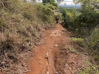
Swerving, flowy singletrack, first part to keelback from ridgeline is old-school hand built. Other part wider, machine built to Haydns Hump.

Access Info

Traverse back Rigeline Gravity, passing thru Keelback, and connecting with The Hump trail hub.

Tags

Trail Supporters

  • Greg McLindon
    since 2013
    Maintainer
  • Aneta George
    since 2013
    Maintainer
  • past supporters

  • McLean Solutions
    2013
    Builder
  • Trevor Smith
    2009
    Builder

Local Trail Association

Traditionally Indigenous Territory

Recent Activity on Trail

Past Week
  • 0 rides
  •  
6 Months
  • 9 rides
  • 12 miles avg distance
All
  • 132 rides
  • Last: Nov 17, 2026
c1c2c3c4
January
February
March
April
May
June
July
August
September
October
November
December
update trails status or condition

Whiptail Trail Reports

Status:
on Aug 17, 2026
Very Dry
Avg: 3.99 (3 votes)
Your vote: 0

view (4,778)
close
      Directions to whiptail-33752 trailhead (-19.327370, 146.745040)

      Photos

      5 more »
      mtb
      42 |
      Apr 19, 2020 @ 11:09pm
      Apr 19, 2020
      mtb
      43 |
      Apr 18, 2019 @ 6:04pm
      Apr 18, 2019
      mtb
      54 |
      Apr 18, 2019 @ 6:04pm
      Apr 18, 2019
      mtb
      72 |
      Dec 26, 2018 @ 11:50am
      Dec 26, 2018

      Videos

      4 more »
      Townsville's Trails: Whiptail to Ironbark Hub
      mtb
      7:12 | 254 | Nov 18, 2020 , Townsville
      Douglas MTB Reserve - Easy Street, Whiptail,...
      mtb
      1588 | Aug 16, 2015 , Townsville
      Whiptail
      mtb
      0:16 | 132 | Jun 1, 2019 , Townsville
      Townsvilles Trails: Whiptail into Ridgeline...
      ebike
      8:04 | 197 | Nov 18, 2020 , Townsville

      Routes with this trail

      more »
      ★ 3.5 • 10 miles • 1,328 ft • 20 •
      Mother Nature forced us off our original course but riders don’t let down your guard. Actually, better...
      53 miles • 4,718 ft • 32 • Point to Point • Race •
      Three MTB venues in one ride: Cape Pallarenda, Douglas Mountain Bike Reserve, Ross River Dam. Linked by...
      8 miles • 1,189 ft • 12 • Loop • Race •
      Stage 2: Enjoy the centrepiece of Townsville mountain biking's crown jewels. Tough climbs, thrilling...
      4.0 ★★★★★
      3 Ratings
      5 ★ 33%
      4 ★ 33%
      3 ★ 33%
      2 ★
      1 ★

      Reviews / Comments

      No reviews yet, be the first to write a review or ask a question.
      Use trail reports to comment on trail conditions.


      We hope you've been enjoying Trailforks!

      Create a FREE account to view all trail reviews and much more.

      • By Rockwheelers TRMBC & contributors
      • #33752 - 2,372 views

      Frequently Asked Questions

      ▼ Where is Whiptail located?
      Whiptail is located in Douglas Mountain Bike Park, Townsville, Australia. It is part of the Douglas Mountain Bike Park trail network. The trailhead is located at coordinates -19.32737, 146.74504.
      ▼ How hard is Whiptail?
      Whiptail is rated as Blue difficulty. The physical rating is Moderate. The average grade is 2.7%. The climb difficulty is rated Blue.
      ▼ What is the elevation gain for Whiptail?
      Whiptail has 141 ft of elevation gain. The trail has 50 ft of elevation descent. The elevation ranges from 327 ft to 455 ft.
      ▼ Is Whiptail a point to point trail?
      Whiptail is not a point to point trail. The direction is Both Directions. The trail type is singletrack.
      ▼ How long is Whiptail?
      Whiptail is 3,484 ft long. The trail type is singletrack.
      ▼ Are dogs allowed on Whiptail?
      Yes, dogs are allowed on Whiptail. Please keep dogs on a leash where required and clean up after them.
      ▼ When is the best time of year to ride Whiptail?
      Whiptail is best visited during: Apr-Dec.
      ▼ How do I access Whiptail? Where is the closest parking trailhead?
      The closest parking and trailhead locations to Whiptail are: View all parking locations in the area.
      ▼ How long does it take to ride Whiptail?
      Based on recorded activities, it takes an average of 8 minutes to ride Whiptail. The trail is 3,484 ft long. Actual times will vary based on fitness level, conditions, and pace. View recent activity logs for more details.
      ▼ How busy is Whiptail?
      Whiptail is a very popular trail. There have been 4,618 recorded activities on this trail. The trail has received 4,778 check-ins. View recent activity on this trail.

      Hit the Trail

      Open in App

      Get this trail on your phone instantly.

      open trail in app

      Download Trail

      Save to wishlist, Garmin & download.
      save the trail

      Find Related Routes

      Find routes and users activities that include this trail.
      find routes for this trail

      You must enter a description before submitting.