more stats
7.4 miles
Distance
678 ft
Climb
-468 ft
Descent
00:43:41
Avg time
210 ft
Altitude change
4,246 ft
Altitude min
4,876 ft
Altitude max
4,249 ft
Altitude start
4,459 ft
Altitude end
0.5%
Grade
-22.7%
Grade max
47.7%
Grade min
3 miles
Distance climb
4 miles
Distance down
2,556 ft
Distance flat
00:43:41
Avg time

White Rock Loop Rd Details

  • Activities
    • Mountain Bike
    • Hike
    • Trail Running
  • Riding Area
    Antelope Island
    Syracuse, Utah
  • Difficulty Rating
  • Local Popularity
    75 in Mountain Biking [+]
    • 15 in Trail Running
    • 50 in Hiking
  • Global Ranking
    #109342 in Mountain Biking [+]
    • #159674 in Trail Running
    • #152466 in Hiking
  • State Ranking
    #1,919 in Mountain Biking · Utah [+]
    • #3,855 in Trail Running
    • #3,683 in Hiking
  • Hiking SAC Scale
    T1 Hiking
  • Trail Type
    Singletrack
  • Direction
    Both Directions
  • Climb Difficulty
    Green
  • Physical Rating
    Moderate
  • Land Owner
    Utah State Parks

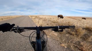
Mostly wide track with some double track. Mostly used as an access trail to get to the more interesting singletrack

Tags

Trail Supporters

  • BLM
    BLM
    Land Manager

Traditionally Indigenous Territory

Recent Activity on Trail

Past Week
  • 1 rides
  • 8 miles average
6 Months
  • 2 rides
  • 10 miles avg distance
All
  • 107 rides
  • Last: Oct 19, 2026
update trails status or condition

White Rock Loop Rd Trail Reports

statusdatedescription
Oct 16, 2026 @ 5:53pm (America/Boise)
Oct 16, 2026
Perfect hero dirt
May 16, 2026 @ 9:42am (America/Denver)
May 16, 2026
Mar 23, 2026 @ 11:28am (America/Denver)
Mar 23, 2026
Aug 10, 2024 @ 3:32pm
Aug 10, 2024
Very minimal bugs to be found. Perfectly rideable.
May 24, 2024 @ 10:51am
May 24, 2024
bugs are starting to get thicker but it was still rideable. Lost of grasshoppers
more »
Status:
on Oct 16, 2026
Ideal
Avg: 3.82 (6 votes)
Your vote: 0

view (438)
close
      Directions to white-rock-loop-rd trailhead (41.023820, -112.239730)

      Photos

      31 more »
      mtb
      98 |
      Jun 13, 2023 @ 11:24pm
      Jun 13, 2023
      mtb
      109 |
      Oct 24, 2021 @ 1:49pm
      Oct 24, 2021
      mtb
      99 |
      Oct 16, 2021 @ 8:35pm
      Oct 16, 2021
      mtb
      116 |
      Aug 8, 2021 @ 7:06am
      Aug 8, 2021

      Videos

      1 more »
      They’re Bison! Antelope Island Winter MTB...
      mtb
      33:50 | 251 | Jan 7, 2023 , Syracuse

      Routes with this trail

      ★ 3.7 • 16 miles • 1,804 ft • 11 •
      Antelope Island State Park
      11 miles • 1,124 ft • 7 •
      This is a nice loop from the Whiterocks parking lot, up the Whiterocks access trail, around White Rocks...
      16 miles • 1,806 ft • 11 • Race •
      SATURDAY 9/28/19 @ 9:00am WHITE ROCK BAY TRAILHEAd ANTELOPE ISLAND STATE PARK, UT Packet pickup day of...
      3.7 ★★★★★
      6 Ratings
      5 ★ 33%
      4 ★ 17%
      3 ★ 33%
      2 ★ 17%
      1 ★

      3 Reviews & Comments

      TedTwin
      Used it as the final connection piece for the clockwise loop. I was tired and that lasts switchback almost got me. Keep your legs and you’ll love it. Kind of Sandy decent with softball-to-basketball sized boulders in the double track.
      ArthurUtah ArthurUtah
      11/15/18 No bugs. Really nice. Bugs for like cold weather.
      NedBundy
      Bring the strongest bug spray you can find. Cloud of gnats so thick they cast a shadow. Windward side riding is fine but the leeward (east) was intolerable.

      We hope you've been enjoying Trailforks!

      Create a FREE account to view all trail reviews and much more.

      • By toddTF Pro Trailforks & contributors
      • #10995 - 4,321 views

      Frequently Asked Questions

      ▼ Where is White Rock Loop Rd located?
      White Rock Loop Rd is located in Antelope Island, Syracuse, Utah, United States. It is part of the Antelope Island trail network. The trailhead is located at coordinates 41.02382, -112.23973.
      ▼ How hard is White Rock Loop Rd?
      White Rock Loop Rd is rated as Green difficulty. The physical rating is Moderate. The average grade is 0.5%. The climb difficulty is rated Green.
      ▼ What is the elevation gain for White Rock Loop Rd?
      White Rock Loop Rd has 678 ft of elevation gain. The trail has 468 ft of elevation descent. The elevation ranges from 4,246 ft to 4,876 ft.
      ▼ Is White Rock Loop Rd a point to point trail?
      White Rock Loop Rd is not a point to point trail. The direction is Both Directions. The trail type is singletrack.
      ▼ How long is White Rock Loop Rd?
      White Rock Loop Rd is 7.4 miles long. The trail type is singletrack.
      ▼ Are dogs allowed on White Rock Loop Rd?
      There is no information about dogs being allowed on White Rock Loop Rd. Check with local trail managers or the trail page for the latest access rules.
      ▼ How do I access White Rock Loop Rd? Where is the closest parking trailhead?
      The closest parking and trailhead locations to White Rock Loop Rd are: View all parking locations in the area.
      ▼ How long does it take to ride White Rock Loop Rd?
      Based on recorded activities, it takes an average of 44 minutes to ride White Rock Loop Rd. The trail is 7.4 miles long. Actual times will vary based on fitness level, conditions, and pace. View recent activity logs for more details.
      ▼ How busy is White Rock Loop Rd?
      White Rock Loop Rd is a very popular trail. There have been 446 recorded activities on this trail. The trail has received 438 check-ins. View recent activity on this trail.

      Hit the Trail

      Open in App

      Get this trail on your phone instantly.

      open trail in app

      Download Trail

      Save to wishlist, Garmin & download.
      save the trail

      Find Related Routes

      Find routes and users activities that include this trail.
      find routes for this trail

      You must enter a description before submitting.