
more stats
3,543 ft
Distance
9 ft
Climb
-293 ft
Descent
00:07:48
Avg time
-283 ft
Altitude change
1,586 ft
Altitude min
1,879 ft
Altitude max
1,879 ft
Altitude start
1,594 ft
Altitude end
-8%
Grade
-48.9%
Grade max
6.4%
Grade min
295 ft
Distance climb
2,844 ft
Distance down
404 ft
Distance flat
00:07:48
Avg time

Windradtrail Details

  • Activities
    • Mountain Bike
    • E-Bike
    • Hike
    • Trail Running
  • Riding Area
    Jura Trails Neumarkt
    Neumarkt in der Oberpfalz
  • Difficulty Rating
  • Voted Difficulty
    Blue (4 votes)
  • Local Popularity
    100 in Mountain Biking [+]
    • 100 in E-Biking
    • 5 in Trail Running
    • 5 in Hiking
  • Global Ranking
    #23357 in Mountain Biking [+]
    • #2367 in E-Biking
    • #213634 in Trail Running
    • #204743 in Hiking
  • National Ranking
    #840 in Mountain Biking · Germany [+]
    • #67 in E-Biking
    • #1,596 in Trail Running
    • #2,002 in Hiking
  • Trail Type
    Singletrack
  • Bike Type
    AM, XC
  • Direction
    Downhill Only
    Popular Direction Shown
  • Trail Visibility
    Always easy to follow
  • eBike Allowed
  • TTFs on Trail
    Berm, Drop, Jump

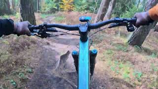
Naturbelassene Vollgasstrecke.
Am Anfang geht es mit einem kleinen Drop-Inn auf die Strecke.
Im oberen Teil recht flach und tretlastig, bis es dann wieder gepflegt bergab geht und du dein Bike ordentlich fliegen lassen kannst.

Tags
BermsDropsJumps

Local Trail Association

Recent Activity on Trail

Past Week
  • 0 rides
  •  
6 Months
  • 28 rides
  • 21 miles avg distance
All
  • 219 rides
  • Last: Oct 18, 2026
c1c2c3c4
January
February
March
April
May
June
July
August
September
October
November
December
Status:
on Jul 19, 2026
Dry
Avg: 4.19 (15 votes)
Your vote: 0

view (1,420)
close
      Directions to windradtrail trailhead (49.255490, 11.509140)

      Photos

      11 more »
      mtb
      75 |
      Jun 18, 2025 @ 10:28pm
      Jun 18, 2025
      mtb
      131 |
      Sep 22, 2024 @ 1:17am
      Sep 22, 2024
      mtb
      132 |
      May 13, 2024 @ 2:28am
      May 13, 2024
      mtb
      125 |
      Apr 1, 2024 @ 11:48pm
      Apr 1, 2024

      Videos

      1 more »
      Juratrails Neumarkt Windradtrail 11-2025
      mtb
      4:15 | 63 | Mar 8, 2026 , Neumarkt in der Oberpfalz
      4.3 ★★★★★
      15 Ratings
      5 ★ 40%
      4 ★ 47%
      3 ★ 13%
      2 ★
      1 ★

      8 Reviews & Comments

      larry81541 larry81541
      Lots of fun and really high quality build. Reminds me of the flowy trails in Finale Ligure. Thank you to the builders!
      Starkkkk
      Schön flowig für'n Feierabend.. worth it!
      Her-Berg Her-Berg
      Sc höner Trail, Einstufung in blau passt. Eine etwas schwierigere Passage, welche nach einer Rechtskurve steil runter führt. Im Herbst mit viel Laub schwer einzuschätzen, aber keine größeren Steine oder Wurzeln vorhanden und genügend Auslauf.

      We hope you've been enjoying Trailforks!

      Create a FREE account to view all trail reviews and much more.

      • By elreyrulesTF Pro ELREY & contributors
      • #66207 - 5,024 views

      Frequently Asked Questions

      ▼ Where is Windradtrail located?
      Windradtrail is located in Jura Trails Neumarkt, Neumarkt in der Oberpfalz, Germany. It is part of the Jura Trails Neumarkt trail network. The trailhead is located at coordinates 49.25549, 11.50914.
      ▼ How hard is Windradtrail?
      Windradtrail is rated as Blue difficulty. The average grade is 8%.
      ▼ What is the elevation gain for Windradtrail?
      Windradtrail has 9 ft of elevation gain. The trail has 293 ft of elevation descent. The elevation ranges from 1,586 ft to 1,879 ft.
      ▼ Is Windradtrail a point to point trail?
      Yes, Windradtrail is a point to point trail. The direction is Downhill Only. The trail type is singletrack.
      ▼ How long is Windradtrail?
      Windradtrail is 3,543 ft long. The trail type is singletrack.
      ▼ Are dogs allowed on Windradtrail?
      There is no information about dogs being allowed on Windradtrail. Check with local trail managers or the trail page for the latest access rules.
      ▼ How do I access Windradtrail? Where is the closest parking trailhead?
      The closest parking and trailhead locations to Windradtrail are: View all parking locations in the area.
      ▼ How long does it take to ride Windradtrail?
      Based on recorded activities, it takes an average of 8 minutes to ride Windradtrail. The trail is 3,543 ft long. Actual times will vary based on fitness level, conditions, and pace. View recent activity logs for more details.
      ▼ How busy is Windradtrail?
      Windradtrail is a very popular trail. There have been 1,000 recorded activities on this trail. The trail has received 1,420 check-ins. View recent activity on this trail.

      Hit the Trail

      Open in App

      Get this trail on your phone instantly.

      open trail in app

      Download Trail

      Save to wishlist, Garmin & download.
      save the trail

      Find Related Routes

      Find routes and users activities that include this trail.
      find routes for this trail

      You must enter a description before submitting.