X-LINE Details
-
Activities
- Mountain Bike
- E-Bike
-
Riding AreaBike-Circus - Saalbach Hinterglemm
Saalbach Hinterglemm -
Ref NumberSH74
-
Difficulty Rating
-
Voted DifficultyDouble Black Diamond (9 votes)
-
Trail TypeMachine Groomed
-
Bike TypeDH, AM
-
DirectionDownhill OnlyPopular direction shown
-
Alpine TrailYes
-
eBike AllowedYes up to Class 1
-
TTFs on TrailBerm, Bridge
-
Global Ranking
-
Local Popularity75 in Mountain Biking [+]
- 60 in E-Biking
-
Land Owner
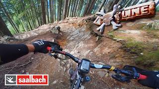
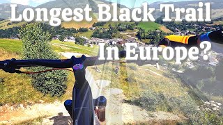
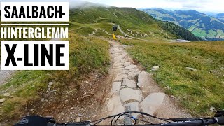
With a total length of more than 6 km and a vertical drop of 1025 m, the X-Line powered by CONTI winds its way down from the summit to the valley station of the Schattberg lift, making it one of the longest freeride trails in Europe. On this variety-packed singletrail with its downhill character, there are numerous passages with obstacles and roots. All bikers, from soulriders to downhill pros are sure to find what they are looking for.
Awaiting bikers in the upper section is a flowing singletrail with magnificent panoramic views. The stage from the mid station is somewhat more tricky and contains many Northshore elements and roots. Once you are almost at the bottom, you can take your pick between a leisurely ride to the valley station, a technically more difficult rooty option, or an adapted slope style run.
More Stats for X-LINE mountain bike trail trail
-
Altitude change-3,286 ft
-
Altitude min3,288 ft
-
Altitude max6,575 ft
-
Altitude start6,575 ft
-
Altitude end3,287 ft
-
Grade-15.5%
-
Grade max-75.5%
-
Grade min9.1%
-
Distance climb305 ft
-
Distance down4 miles
-
Distance flat36 ft
-
Avg time00:28:33
-
Avg reverse time01:29:33
- view trail stats
- Unknown
- Snow Groomed
- Snow Packed
- Snow Covered
- Snow Cover Partial
- Freeze/thaw Cycle
- Icy
- Prevalent Mud
- Wet
- Variable
- Ideal
- Dry
- Very Dry
The colour categories are based on what percentage of riders are riding a trail in its intended direction.
- > 96%
- > 90%
- > 80%
- > 70%
- > 50%
- < 50%
- bi-directional trail
- no data
- < 2 days
- < 1 week
- < 2 weeks
- < 1 month
- < 6 months
- > 6 months
- Downhill Only
- Downhill Primary
- Both Directions
- Uphill Primary
- Uphill Only
- One Direction
- Description
- Photos
- Description & Photos
- Videos
- most popular
- popular
- less popular
- not popular
- mountain biking recent
- mountain biking (>6 month)
- hiking (1 year)
- moto (1 year)
- Downhill Ski
- Backcountry Ski
- Nordic Ski
- Snowmobile
Save the current map location and zoom level as your default home location whenever this page is loaded.
SaveX-LINE Trail Reports
Recent Ridelog Activity on Trail
- 4 rides
- 60.1 km avg distance
- 29 rides
- 54.1 km avg distance
- 160 rides
- Last: Jul 18, 2025
Photos
4 Reviews & Comments
We hope you've been enjoying Trailforks!
Create a FREE account to view trail comments and much more.
Videos
Nearby Trails
- Pinzgauer Spaziergang Teil 1 112 ft
- Schattberg Sprinter 2,608 ft
- Fairy Line 3,507 ft
- Limberg 4er 4,741 ft
- Sheepy Hollow-line 1 mile
Bike-Circus - Saalbach Hinterglemm
- By brenthillier
NSMBA TRAILFORKS & contributors
- #5547 - 15,156 views
- follow/subscribe
- login to download gpx or kml files.
You must enter a description before submitting.