
Open in App
Get this trail on your phone instantly.

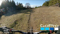
It is a fast flowy trail with a rocky needles with great traction. It has some drops for taking fun lines. The trail features are marked (such as places where you have to be a little more focused).
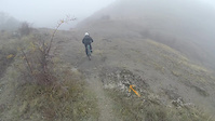
The uphill is shuttle-able to a certain point with even an ordinary vehicle as the road has good asphalt. Then there are two options - hike and bike to the trail from the uphill section, or to take the fire road to the ridge / start of the trail (last couple of km is a push / walk as it is very steep).
Due to the nature of the terrain (rocky needles), it is rideable almost all year round.
When you start descending, look for the entrance of the trail to your left, be careful not to continue on the west ridge as it is a motor bike trail which is not very bike downhill friendly (lots of up hills).
| c1 | c2 | c3 | c4 |
|---|---|---|---|
January | February | March | April |
May | June | July | August |
September | October | November | December |

Service Road Atlas is a free to use, community-driven service for viewing and creating reports on the numerous back-country service roads around B.C. and Alberta.
Save the current map location and zoom level as your default home location whenever this page is loaded.
Save
No reviews yet, be the first to write a review or ask a question.
Use trail reports to comment on trail conditions.
We hope you've been enjoying Trailforks!
Create a FREE account to view trail comments and much more.
You must enter a description before submitting.

