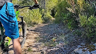
The Bigfoot Trail is a long distance hiking trail through the Klamath Mountains of northwest California and, briefly, southwest Oregon. The trail begins in the Yolla Bolly-Middle Eel Wilderness and ends near Redwood National and State Parks at the Pacific Ocean near Crescent City, CA. The establishment of this route will lead to a deeper understanding and awareness for this little known corner of California—in essence promoting greater future sustainability for this botanical wonderland. The major focus along the trail is conifer diversity, passing 32 species along the 360 miles. Also, en route, one traverses six wilderness areas, one National Park, and one State Park.
Of the 360 miles, approximately 100 miles (160 km) are along seldom used Forest Service roads while the remaining segments are backcountry trails, either in wilderness or on National Forest land. The Pacific Crest Trail briefly coincides with the Bigfoot Trail in the northern Marble Mountain Wilderness and north of Seiad Valley to the edge of the Red Buttes Wilderness. Due to the strenuous nature of the trail and the fact that some section have been un-maintained for many years it is not a trail that can be hiked quickly. Experience using map and compass as well as the ability to read the landscape are necessary for a successful thru-hike. The Bigfoot Trail was originally proposed by Michael Kauffmann in 2009 as a suggested route to navigate the Klamath Mountains from south to north as well as a long-trail to introduce nature lovers to the biodiversity of the Klamath Mountains region.
Of the 360 miles, approximately 100 miles (160 km) are along seldom used Forest Service roads while the remaining segments are backcountry trails, either in wilderness or on National Forest land. The Pacific Crest Trail briefly coincides with the Bigfoot Trail in the northern Marble Mountain Wilderness and north of Seiad Valley to the edge of the Red Buttes Wilderness. Due to the strenuous nature of the trail and the fact that some section have been un-maintained for many years it is not a trail that can be hiked quickly. Experience using map and compass as well as the ability to read the landscape are necessary for a successful thru-hike. The Bigfoot Trail was originally proposed by Michael Kauffmann in 2009 as a suggested route to navigate the Klamath Mountains from south to north as well as a long-trail to introduce nature lovers to the biodiversity of the Klamath Mountains region.
- Hike
Login to see your progress towards riding all the trails and routes in this list.
Trails
| title | riding area | rating | distance | completed | |||
|---|---|---|---|---|---|---|---|
| 1 | East Tule Creek | 6 miles | |||||
| 2 | South Fork Trinity River Trail | 17 miles | |||||
| 3 | Bear Creek | 7 miles | |||||
| 4 | Stuart Fork | 13 miles | |||||
| 5 | Caribou Lakes | 11 miles | |||||
| 6 | Trail Creek | 3 miles | |||||
| 7 | Seiad Valley Connection | 7 miles | |||||
| 8 | PCT - Marble Mountain (N) | 25 miles | |||||
| 9 | PCT - Devils Peak | 14 miles | |||||
| 10 | Little Bald Hills | 9 miles |
Displaying 10
Videos
0:18 |
597 |
Sep 12, 2019
Recent Trail Reports
| status | trail | date | condition | |
|---|---|---|---|---|
| Little Bald Hills | Oct 19, 2025 @ 8:29am (America/Los_Angeles) Oct 19, 2025 | view | ||
| South Fork Trinity River Trail | Oct 6, 2024 @ 9:46am Oct 6, 2024 | view | ||
| Caribou Lakes | Jul 23, 2022 @ 9:04pm Jul 23, 2022 | view | ||
| Stuart Fork | Apr 1, 2022 @ 12:25am Apr 1, 2022 | view |
Total Trails
10
Total Distance
111 miles
Total Descent
-21,818 ft
Total Climb
24,036 ft
close
-
Layers w
- Weather Layers
- Pro
- Pro
- Pro
- Pro
- Pro
- Pro
- More Layers
- Pro
- Pro
- Pro
- Pro
-
Upgrade to

3D
Trail Conditions
- Unknown
- Snow Groomed
- Snow Packed
- Snow Covered
- Snow Cover Partial
- Freeze/thaw Cycle
- Icy
- Prevalent Mud
- Wet
- Variable
- Ideal
- Dry
- Very Dry
Trail Flow (Ridden Direction)
Trailforks scans users ridelogs to determine the most popular direction each trail is ridden. A good flowing trail network will have most trails flowing in a single direction according to their intension.
The colour categories are based on what percentage of riders are riding a trail in its intended direction.
The colour categories are based on what percentage of riders are riding a trail in its intended direction.
- > 96%
- > 90%
- > 80%
- > 70%
- > 50%
- < 50%
- bi-directional trail
- no data
Trail Last Ridden
Trailforks scans ridelogs to determine the last time a trail was ridden.
- < 2 days
- < 1 week
- < 2 weeks
- < 1 month
- < 6 months
- > 6 months
Trail Ridden Direction
The intended direction a trail should be ridden.
- Downhill Only
- Downhill Primary
- Both Directions
- Uphill Primary
- Uphill Only
- One Direction
Contribute Details
Colors indicate trail is missing specified detail.
- Description
- Photos
- Description & Photos
- Videos
Trail Popularity ?
Trailforks scans ridelogs to determine which trails are ridden the most in the last 9 months.
Trails are compared with nearby trails in the same city region with a possible 25 colour shades.
Think of this as a heatmap, more rides = more kinetic energy = warmer colors.
- most popular
- popular
- less popular
- not popular
ATV/ORV/OHV Filter
Max Vehicle Width
inches
US Cell Coverage
Legend

Radar Time
Activity Recordings
Trailforks uses anonymized public activity data.
?
Activity Recordings
Trailforks uses anonymized public activity data.
?
Personal Heatmap
▶
Activity Types
all
/
none
▶
Options
2
Date range
month
–
Winter Trails
Warning
A routing network for winter maps does not exist. Selecting trails using the winter trails layer has been disabled.
Missing Trails
Most Popular
Least Popular
Trails are colored based on popularity. The more popular a trail is, the more red. Less popular trails trend towards green.
Jump Magnitude Heatmap
Heatmap of where riders jump on trails. Zoom in to see individual jumps, click circles to view jump details.
BC Backroad Status
![map legend]()
Service Road Atlas is a free to use, community-driven service for viewing and creating reports on the numerous back-country service roads around B.C. and Alberta.

Slope Aspect
Direction the slope faces
Trails Deemphasized
Trails are shown in grey.
Only show trails with no bike usage.
Suggested Layers
Based on selected activity type
Save the current map location and zoom level as your default home location whenever this page is loaded.
Save
Trail transparency
Average difficulty
Mountain Bike is not supported on all trail sections, see trails for more details.
Trails and Routes in List - Distance by Difficulty
Trails and Routes in List - Difficulty Totals
- By chuktA
 TRAILFORKS NFTA
 - #922 - 1,018 views