close
-
Layers w
- Weather Layers
- Pro
- Pro
- Pro
- Pro
- Pro
- Pro
- More Layers
- Pro
- Pro
- Pro
- Pro
-
Upgrade to

3D
Trail Conditions
- Unknown
- Snow Groomed
- Snow Packed
- Snow Covered
- Snow Cover Partial
- Freeze/thaw Cycle
- Icy
- Prevalent Mud
- Wet
- Variable
- Ideal
- Dry
- Very Dry
Trail Flow (Ridden Direction)
Trailforks scans users ridelogs to determine the most popular direction each trail is ridden. A good flowing trail network will have most trails flowing in a single direction according to their intension.
The colour categories are based on what percentage of riders are riding a trail in its intended direction.
The colour categories are based on what percentage of riders are riding a trail in its intended direction.
- > 96%
- > 90%
- > 80%
- > 70%
- > 50%
- < 50%
- bi-directional trail
- no data
Trail Last Ridden
Trailforks scans ridelogs to determine the last time a trail was ridden.
- < 2 days
- < 1 week
- < 2 weeks
- < 1 month
- < 6 months
- > 6 months
Trail Ridden Direction
The intended direction a trail should be ridden.
- Downhill Only
- Downhill Primary
- Both Directions
- Uphill Primary
- Uphill Only
- One Direction
Contribute Details
Colors indicate trail is missing specified detail.
- Description
- Photos
- Description & Photos
- Videos
Trail Popularity ?
Trailforks scans ridelogs to determine which trails are ridden the most in the last 9 months.
Trails are compared with nearby trails in the same city region with a possible 25 colour shades.
Think of this as a heatmap, more rides = more kinetic energy = warmer colors.
- most popular
- popular
- less popular
- not popular
ATV/ORV/OHV Filter
Max Vehicle Width
inches
US Cell Coverage
Legend

Radar Time
Activity Recordings
Trailforks uses anonymized public activity data.
?
Activity Recordings
Trailforks uses anonymized public activity data.
?
Personal Heatmap
▶
Activity Types
all
/
none
▶
Options
2
Date range
month
–
Winter Trails
Warning
A routing network for winter maps does not exist. Selecting trails using the winter trails layer has been disabled.
Missing Trails
Most Popular
Least Popular
Trails are colored based on popularity. The more popular a trail is, the more red. Less popular trails trend towards green.
Jump Magnitude Heatmap
Heatmap of where riders jump on trails. Zoom in to see individual jumps, click circles to view jump details.
BC Backroad Status
![map legend]()
Service Road Atlas is a free to use, community-driven service for viewing and creating reports on the numerous back-country service roads around B.C. and Alberta.

Slope Aspect
Direction the slope faces
Trails Deemphasized
Trails are shown in grey.
Only show trails with no bike usage.
Suggested Layers
Based on selected activity type
Save the current map location and zoom level as your default home location whenever this page is loaded.
Save
No description for Andover has been added yet!
Login or register to submit one.
Activities Click to view
- Mountain Bike
325 trails
- E-Bike
27 trails
- Gravel Bike
0 trails
- Adaptive Bike
0 trails
- Winter Fat Bike
0 trails
- Hike
342 trails
- Trail Running
341 trails
- Snowshoe
9 trails
- Nordic Ski
8 trails
Region Details
- 61
- 2
- 84
- 145
- 30
Region Status
Open as of Jun 11, 2026Stats
- Avg Trail Rating
- Trails (view details)
- 339
- Trails Mountain Bike
- 325
- Trails E-Bike
- 27
- Trails Horse
- 1
- Trails Hike
- 342
- Trails Trail Running
- 341
- Trails Snowshoe
- 9
- Trails Nordic Ski
- 8
- Total Distance
- 117 miles
- Total Descent
- 9,652 ft
- Total Vertical
- 368 ft
- Highest Trailhead
- 414 ft
- Reports
- 1,463
- Photos
- 259
- Ridden Counter
- 92,012
Sub Regions
-
Doyle Link
- 1
-
Harold Parker State Forest
- 2
- 12
- 102
- 26
-
Indian Ridge Reservation
- 8
- 1
-
Merrimack River Trail Network
- 7
- 7
- 2
-
Nat Smith Reservation
-
Purdon Reservation
- 1
-
South Street Trails
-
Stanley Reservation
-
Ward Reservation
- 42
- 22
- 2
Popular Andover Mountain Biking Trails
• 100 ★ 4.0 • 1,617 ft • 24 ft • 1,477 •
Popular blue difficulty singletrack. This multi-use trail can be used both directions and has a moderate overall physical rating with a 24 ft blue climb. Trail visibility is always easy to follow. On average it takes 3 minutes to complete this trail.
• 100 ★ 5.0 • 1,716 ft • 44 ft • 1,334 •
Popular blue difficulty singletrack. This multi-use trail can be used both directions and has a moderate overall physical rating with a 44 ft blue climb. Trail visibility is always easy to follow. On average it takes 3 minutes to complete this trail.
• 100 ★ 4.0 • 2,756 ft • 29 ft • 1,288 •
Technical trail that runs parallel to "Chowdah" aka "Yellow Diamond Trail". Lots of rocks and roots will challenge you from start to finish. A great technical ride that is the essence of HP riding.
• 100 ★ 4.0 • 869 ft • 9 ft • 1,223 •
Plenty of rock slabs to ride up or down depending which way you go.
• 100 ★ 0.0 • 1,278 ft • 14 ft • 1,220 •
Popular blue difficulty singletrack. This multi-use trail can be used both directions and has a moderate overall physical rating with a 14 ft blue climb. Trail visibility is always easy to follow. On average it takes 1 minutes to complete this trail.
• 100 ★ 0.0 • 747 ft • 25 ft • 1,167 •
Popular blue difficulty singletrack. This multi-use trail can be used both directions and has a moderate overall physical rating with a 25 ft blue climb. Trail visibility is always easy to follow. On average it takes 1 minutes to complete this trail.
• 100 ★ 5.0 • 2,103 ft • 46 ft • 1,144 •
This a very fun and flowy trail if you ride West to East, mainly towards the end. It's probably one of the flowiest trails in the park, and even has a tabletop at the end.
• 100 ★ 4.0 • 3,504 ft • 84 ft • 1,053 •
is a "must do" for the discerning Harold Parker explorer. Rock faces at the start, rock gardens at the end.
Andover Mountain Bike Routes
Yellow Diamond Route Featured
★ 4.4 • 3 miles • 245 ft • 6 • Point to Point •
This is a challenging intermediate route suitable for solid intermediate and advanced riders. The trails...
Bay Circuit Trail Featured
5 miles • 256 ft • 13 • Point to Point •
This is the Harold Parker Section only of the Bay Circuit Trail
Wicked Ride of the East Featured
★ 3.3 • 20 miles • 1,218 ft • 0 • Loop •
Wicked Ride of the East Course
★ 5.0 • 16 miles • 886 ft • 25 • Loop •
The 2021 Wicked Ride Hero Route will push your limits and serve up more technical riding than most folks...
★ 4.0 • 9 miles • 606 ft • 14 • Loop •
This is an extremely technical/advanced featuring almost all of the most fun+difficult trails at HP. If...
★ 5.0 • 31 miles • 1,916 ft • 41 • Loop •
Thirty mile route beginning at the Jenkins lot an touring most all of Harold Parker and Ward Reservation.
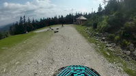
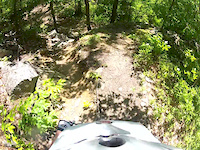
Photos of Andover Mountain Bike
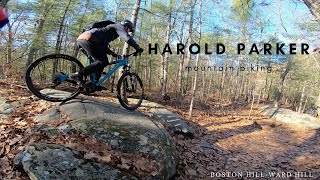
Videos of Andover Mountain Bike
trail: Trail #1
6:01 |
193 |
Sep 2, 2014
trail: Hemlock Trail
0:34 |
100 |
Jun 3, 2013
trail: Exit to Boston Hill CR
9:11 |
299 |
Nov 21, 2022 , Andover

trail: Deer Jump Trail (BCT)
8:10 |
715 |
May 15, 2020 , Andover

3:23 |
1519 |
Aug 28, 2018
Recent Trail Reports
| status | trail | date | condition | info | user |
|---|---|---|---|---|---|
| Twisted Pecker | Jun 11, 2026 @ 6:09pm (America/New_York) Jun 11, 2026 | Ideal | DeaDL0K | ||
| Delano Pond Connector West | Jun 11, 2026 @ 5:40pm (America/New_York) Jun 11, 2026 | Ideal | DeaDL0K | ||
| Walker Rd Connector | Jun 11, 2026 @ 5:05pm (America/New_York) Jun 11, 2026 | Ideal | DeaDL0K | ||
| A19 Spur | Jun 11, 2026 @ 5:02pm (America/New_York) Jun 11, 2026 | Ideal | DeaDL0K | ||
| A13-A12 | May 27, 2026 @ 12:26pm (America/New_York) May 27, 2026 | Ideal | TmtbHP | ||
| A14 Spur | May 19, 2026 @ 10:42am (America/New_York) May 19, 2026 | Dry | jogo59 | ||
| Bay Circuit Trail (BCT) | May 10, 2026 @ 10:47am (America/New_York) May 10, 2026 | Unknown | wvcjr | ||
| Rootball Extra | Mar 28, 2026 @ 8:35am (America/New_York) Mar 28, 2026 | Ideal | AndrewHally MRR | ||
| Rootball | Mar 28, 2026 @ 8:35am (America/New_York) Mar 28, 2026 | Ideal | AndrewHally MRR | ||
| Orange Trail 2 | Mar 28, 2026 @ 8:35am (America/New_York) Mar 28, 2026 | Ideal | AndrewHally MRR |
Activity Feed
| username | action | type | title | date |
|---|---|---|---|---|
| Raf28KaCQ | wishlist | region | activity #99380194 | Jul 17, 2026 @ 9:24am Jul 17, 2026 |
| jbrazda | ridden | trail | activity #99014084 | Jul 12, 2026 @ 6:37am Jul 12, 2026 |
| dzolotusky | wishlist | route | activity #99008524 | Jul 12, 2026 @ 5:07am Jul 12, 2026 |
| vanlarry | wishlist | route | activity #98987483 | Jul 11, 2026 @ 7:41pm Jul 11, 2026 |
| ChristianS4c7tw | wishlist | route | activity #98846464 | Jul 10, 2026 @ 4:44am Jul 10, 2026 |
Recent Comments
| username | type | title | comment | date |
|---|---|---|---|---|
| report | H Ooo O ok o | Aug 23, 2024 @ 9:29am Aug 23, 2024 | ||
| trail | This trail is a shallow pond for days after it... | Jun 2, 2024 @ 6:15am Jun 2, 2024 | ||
| trail | Trail doesn't have many features (mostly loose... | Sep 6, 2023 @ 10:16am Sep 6, 2023 | ||
| trail | Nothing too interesting for mountain bike... | Sep 6, 2023 @ 10:13am Sep 6, 2023 | ||
| trail | Short but sweet, challenging beginning... | Aug 12, 2023 @ 6:26am Aug 12, 2023 |
Local Badges
-

Completionist0 awarded -

Big Ride 30k2,427 awarded -

Epic Ride 50k797 awarded -

Top 10 Trails14 awarded -

Descent 100k Badge4 awarded -
Completionist0 awarded
Activity Type Stats
| activitytype | trails | distance | descent | descent distance | total vertical | rating | global rank | state rank | photos | reports | routes | ridelogs |
|---|---|---|---|---|---|---|---|---|---|---|---|---|
| Mountain Bike | 325 | 109 miles | 9,324 ft | 41 miles | 367 ft | #270 | #95 | 247 | 1,459 | 35 | 34,874 | |
| E-Bike | 27 | 5 miles | 456 ft | 2 miles | 200 ft | #7,055 | #2,123 | 5 | 1,123 | 1 | 304 | |
| Horse | 1 | 1,499 ft | 82 ft | 702 ft | 85 ft | 229 | 38 | |||||
| Hike | 342 | 111 miles | 9,347 ft | 40 miles | 367 ft | #1,068 | #489 | 1,451 | 6 | 2,004 | ||
| Trail Running | 341 | 110 miles | 9,327 ft | 40 miles | 367 ft | #831 | #316 | 1 | 1,451 | 5 | 2,583 | |
| Snowshoe | 9 | 2 miles | 66 ft | 2,799 ft | 82 ft | #611 | #242 | 7 | 7 | 128 | ||
| Nordic Ski | 8 | 1 mile | 43 ft | 2,182 ft | 82 ft | #1,575 | #782 | 7 | 69 |
Frequently Asked Questions About Andover
▼
What are the best places to ride in Andover?
Andover has 10 areas to explore for mountain biking. The top rated areas are:
▼
What are the highest rated mountain biking trails in Andover?
The highest rated mountain biking trails in Andover are:
- Crossroads East (4.3/5)
- School Days (4.3/5)
- Yellow Diamond Trail South (4.3/5)
- Exit to Boston Hill CR (4.2/5)
- Blue Loop (4.2/5)
▼
What is the best time of the year to ride in Andover?
Based on ride log data, the most popular months to ride in Andover are:
- May (605 activities)
- October (574 activities)
- June (565 activities)
▼
Where can I park to ride in Andover?
There are 17 parking locations listed in Andover. The most popular parking spots are: View all parking and trailhead locations on the map to plan your visit.
Activities
Trails
- By WillieJacobsz
 Trailforks SBP SWW & contributors
 - Admins: NS NEMBA, SiamDelightRules
- #4021 - 8,869 views
- andover activity log | embed map of Andover mountain bike trails | andover mountain biking points of interest polygons
Downloading of trail gps tracks in kml & gpx formats is enabled for Andover.
You must login to download files.