close
-
Layers w
- Weather Layers
- Pro
- Pro
- Pro
- Pro
- Pro
- Pro
- More Layers
- Pro
- Pro
- Pro
- Pro
-
Upgrade to

3D
Trail Conditions
- Unknown
- Snow Groomed
- Snow Packed
- Snow Covered
- Snow Cover Partial
- Freeze/thaw Cycle
- Icy
- Prevalent Mud
- Wet
- Variable
- Ideal
- Dry
- Very Dry
Trail Flow (Ridden Direction)
Trailforks scans users activity logs to determine the most popular direction each trail is ridden. A good flowing trail network will have most trails flowing in a single direction according to their intension.
The colour categories are based on what percentage of users are riding a trail in its intended direction.
The colour categories are based on what percentage of users are riding a trail in its intended direction.
- > 96%
- > 90%
- > 80%
- > 70%
- > 50%
- < 50%
- bi-directional trail
- no data
Trail Last Ridden
Trailforks scans activity logs to determine the last time a trail was ridden.
- < 2 days
- < 1 week
- < 2 weeks
- < 1 month
- < 6 months
- > 6 months
Trail Ridden Direction
The intended direction a trail should be ridden.
- Downhill Only
- Downhill Primary
- Both Directions
- Uphill Primary
- Uphill Only
- One Direction
Contribute Details
Colors indicate trail is missing specified detail.
- Description
- Photos
- Description & Photos
- Videos
Trail Popularity ?
Trailforks scans activity logs to determine which trails are ridden the most in the last 9 months.
Trails are compared with nearby trails in the same city region with a possible 25 colour shades.
Think of this as a heatmap, more activities = more kinetic energy = warmer colors.
- most popular
- popular
- less popular
- not popular
ATV/ORV/OHV Filter
Max Vehicle Width
inches
US Cell Coverage
Legend

Radar Time
Activity Recordings
Trailforks uses anonymized public activity data.
?
Activity Recordings
Trailforks uses anonymized public activity data.
?
Personal Heatmap
▶
Activity Types
all
/
none
▶
Options
2
Date range
month
–
Winter Trails
Warning
A routing network for winter maps does not exist. Selecting trails using the winter trails layer has been disabled.
Missing Trails
Most Popular
Least Popular
Trails are colored based on popularity. The more popular a trail is, the more red. Less popular trails trend towards green.
Jump Magnitude Heatmap
Heatmap of where users jump on trails. Zoom in to see individual jumps, click circles to view jump details.
BC Backroad Status
![map legend]()
Service Road Atlas is a free to use, community-driven service for viewing and creating reports on the numerous back-country service roads around B.C. and Alberta.

Slope Aspect
Direction the slope faces
Trails Deemphasized
Trails are shown in grey.
Only show trails with no bike usage.
Suggested Layers
Based on selected activity type
Save the current map location and zoom level as your default home location whenever this page is loaded.
Save
No description for APASOA has been added yet!
Login or register to submit one.
Primary Trail Type: Cross-Country
eBikes Allowed:
Yes
AKA: APASOA
Links
Activities Click to view
- Mountain Bike
29 trails
- E-Bike
24 trails
- Hike
29 trails
- Trail Running
29 trails
- Dirtbike/Moto
7 trails
- ATV/ORV/OHV
5 trails
- Snowshoe
18 trails
Region Details
- 2
- 9
- 3
- 2
Region Status
Open as of Jul 19, 2026Local Trail Association
Stats
- Avg Trail Rating
- Trails (view details)
- 16
- Trails Mountain Bike
- 29
- Trails E-Bike
- 24
- Trails Winter Fat Bike
- 5
- Trails Hike
- 29
- Trails Trail Running
- 29
- Trails Dirtbike/Moto
- 8
- Trails ATV/ORV/OHV
- 5
- Trails Snowshoe
- 18
- Total Distance
- 6 miles
- Total Descent
- 180 ft
- Total Vertical
- 67 ft
- Highest Trailhead
- 77 ft
- Reports
- 660
- Photos
- 113
- Completed Counter
- 551
Popular APASOA Mountain Biking Trails
• 100 ★ 5.0 • 1,293 ft • 8 ft • 79 •
Begins at the APASOA parking lot, continues in a freshly logged property and ends at the intersection of La Bénaise, La Main and La Dam trails. This trail leads to trails along the River. ** Débute au terrain de stationnement de...
• 70 ★ 5.0 • 2,484 ft • 12 ft • 62 •
Popular blue difficulty family friendly singletrack. This mountain bike primary trail. It features berm, drop, jump and rock garden. On average it takes 2 minutes to complete this trail.
• 100 ★ 5.0 • 1,877 ft • 25 ft • 55 •
Popular green difficulty family friendly singletrack. This mountain bike primary trail and has a easy overall physical rating. It features berm and ladder bridge. Trail visibility is always easy to follow. On average it takes 3 minutes to complete this trail.
• 80 ★ 5.0 • 2,520 ft • 22 ft • 55 •
Popular blue difficulty singletrack. This mountain bike primary trail. On average it takes 7 minutes to complete this trail.
• 65 ★ 5.0 • 1,535 ft • 25 ft • 42 •
Moderately popular black diamond difficulty family friendly doubletrack. This mountain bike primary trail and has a hard overall physical rating with a 25 ft black diamond climb. Winter use: Classic snow grooming. Trail visibility is always easy to follow. On average it takes 3 minutes to complete this trail.
• 60 ★ 5.0 • 4,039 ft • 50 ft • 34 •
Moderately popular blue difficulty family friendly singletrack. This mountain bike primary trail and has a moderate overall physical rating with a 50 ft blue climb. Winter use: Groomed Smooth snow grooming. Trail visibility is always easy to follow. On average it takes 9 minutes to complete this trail.
• 85 ★ 5.0 • 2,372 ft • 7 ft • 27 •
Popular blue difficulty singletrack. This mountain bike primary trail. On average it takes 5 minutes to complete this trail.
APASOA Mountain Bike Routes
★ 5.0 • 9 miles • 336 ft • 16 • Out & Back •
This route includes most APASOA trails
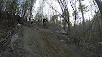
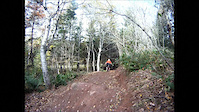
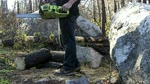
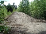
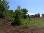
Photos of APASOA Mountain Bike
Videos of APASOA Mountain Bike
trail: Yellow Bucket
0:27 |
166 |
May 1, 2016
trail: Yellow Bucket
4:42 |
420 |
Oct 16, 2011
trail: Yellow Bucket
3:47 |
297 |
Sep 9, 2010
trail: Yellow Bucket
0:35 |
222 |
Aug 15, 2010
trail: Yellow Bucket
0:09 |
149 |
Jun 23, 2009
trail: Yellow Bucket
0:11 |
110 |
Mar 14, 2009
Current Trail Warnings
| status | trail | date | condition | user | info |
|---|---|---|---|---|---|
| Scoudouc | Jul 15, 2026 @ 7:24pm (America/Moncton) Jul 15, 2026 | Unknown | Sebastien685 | ||
| Boosté | Jul 10, 2026 @ 2:50pm (America/Moncton) Jul 10, 2026 | Wet | Sebastien685 | Currently being worked on. Temporarily closed |
Recent Trail Reports
| status | trail | date | condition | info | user |
|---|---|---|---|---|---|
| Malakoff to Irving Road | Jul 15, 2026 @ 7:24pm (America/Moncton) Jul 15, 2026 | Ideal | Sebastien685 | ||
| APASOA to ATV trails | Jul 15, 2026 @ 7:24pm (America/Moncton) Jul 15, 2026 | Ideal | Sebastien685 | ||
| Camp a Norm | Jul 15, 2026 @ 7:24pm (America/Moncton) Jul 15, 2026 | Ideal | Sebastien685 | ||
| Pellerin Road | Jul 15, 2026 @ 7:24pm (America/Moncton) Jul 15, 2026 | Ideal | Sebastien685 | ||
| Connector to Pellerin Road | Jul 12, 2026 @ 9:06am (America/Moncton) Jul 12, 2026 | Ideal | Sebastien685 | ||
| YOLO | Jul 10, 2026 @ 2:50pm (America/Moncton) Jul 10, 2026 | Ideal | Sebastien685 | ||
| La Yeti | Jul 10, 2026 @ 2:50pm (America/Moncton) Jul 10, 2026 | Ideal | Sebastien685 | ||
| Yellow Bucket | Jul 10, 2026 @ 2:50pm (America/Moncton) Jul 10, 2026 | Ideal | Sebastien685 | ||
| Frolic | Jul 10, 2026 @ 2:50pm (America/Moncton) Jul 10, 2026 | Ideal | Sebastien685 | ||
| La Canou | Jul 10, 2026 @ 2:50pm (America/Moncton) Jul 10, 2026 | Ideal | Sebastien685 |
Activity Feed
| username | action | type | title | date |
|---|---|---|---|---|
| Sebastien685 | add | report | activity #99565754 | Jul 19, 2026 @ 1:23pm Jul 19, 2026 |
| Sebastien685 | add | report | activity #99306979 and 4 more | Jul 16, 2026 @ 7:33am Jul 16, 2026 |
| Sebastien685 | add | report | activity #99037699 | Jul 12, 2026 @ 10:37am Jul 12, 2026 |
| Sebastien685 | add | report | activity #98935654 and 6 more | Jul 11, 2026 @ 8:20am Jul 11, 2026 |
| SPDFRK5 | difficultyvote | trail | activity #98173571 and 1 more | Jun 30, 2026 @ 7:19pm Jun 30, 2026 |
Recent Comments
| username | type | title | comment | date |
|---|---|---|---|---|
| report | Still muddy toward the end of the trail. | May 7, 2023 @ 3:45pm May 7, 2023 |
Nearby Areas
| name | distance | ||||
|---|---|---|---|---|---|
| Riverside | 2 | 0.1 km | |||
| Parc Plein Air Cap-Pelé | 10.5 km | ||||
| Irishtown Nature Park | 6 | 4 | 11.8 km | ||
| Humphrey Brook | 14 | 1 | 12.1 km | ||
| Dieppe Rotary Park | 18 | 14 | 3 | 12.4 km |
Local Badges
-

Completionist1 awarded
Activity Type Stats
| activitytype | trails | distance | descent | descent distance | total vertical | rating | global rank | state rank | photos | reports | routes | activity logs |
|---|---|---|---|---|---|---|---|---|---|---|---|---|
| Mountain Bike | 29 | 6 miles | 180 ft | 2 miles | 66 ft | #3,871 | #16 | 107 | 649 | 1 | 1,735 | |
| E-Bike | 24 | 5 miles | 121 ft | 1 mile | 66 ft | #6,930 | #13 | 646 | 1 | 62 | ||
| Winter Fat Bike | 5 | #5,148 | #24 | 1 | ||||||||
| Hike | 29 | 6 miles | 180 ft | 2 miles | 66 ft | #11,050 | #28 | 6 | 649 | 1 | 227 | |
| Trail Running | 29 | 6 miles | 180 ft | 2 miles | 66 ft | #10,524 | #26 | 649 | 1 | 74 | ||
| Dirtbike/Moto | 7 | 2 miles | 20 ft | 3,793 ft | 20 ft | #800 | #3 | 28 | ||||
| ATV/ORV/OHV | 5 | 2 miles | 20 ft | 3,793 ft | 20 ft | #582 | #3 | 25 | ||||
| Snowshoe | 18 | 4 miles | 128 ft | 4,836 ft | 52 ft | #1,010 | #10 | 13 | 1 | 20 |
Frequently Asked Questions About APASOA
▼
What are the highest rated mountain biking trails in APASOA?
The highest rated mountain biking trails in APASOA are:
- Yellow Bucket (4.2/5)
- La Batture (4.2/5)
- Boosté (4.2/5)
- YOLO (4.1/5)
- Scoudouc (4.1/5)
▼
What is the best time of the year to ride in APASOA?
Based on activity log data, the most popular months to ride in APASOA are:
- July (10 activities)
- June (8 activities)
- August (4 activities)
▼
Where can I park to ride in APASOA?
Check the APASOA trail map for trailhead and parking information. Community members regularly update access and parking details for trails in the area.
▼
What is the longest trail in APASOA?
The longest trail in APASOA is Norm Camp to Memramcook Irving at 36.3 km. View all trails sorted by distance.
Activities
Trails
- By bent6543
 TRAILFORKS & contributors
 - Admins: PARKSNB, ChrisNorfolk, themikekowalski, alexisberube
- #27176 - 10,924 views
- apasoa activity log | embed map of APASOA mountain bike trails | apasoa mountain biking points of interest
Downloading of trail gps tracks in kml & gpx formats is enabled for APASOA.
You must login to download files.