close
-
Layers w
- Weather Layers
- Pro
- Pro
- Pro
- Pro
- Pro
- Pro
- More Layers
- Pro
- Pro
- Pro
- Pro
-
Upgrade to

3D
Trail Conditions
- Unknown
- Snow Groomed
- Snow Packed
- Snow Covered
- Snow Cover Partial
- Freeze/thaw Cycle
- Icy
- Prevalent Mud
- Wet
- Variable
- Ideal
- Dry
- Very Dry
Trail Flow (Ridden Direction)
Trailforks scans users ridelogs to determine the most popular direction each trail is ridden. A good flowing trail network will have most trails flowing in a single direction according to their intension.
The colour categories are based on what percentage of riders are riding a trail in its intended direction.
The colour categories are based on what percentage of riders are riding a trail in its intended direction.
- > 96%
- > 90%
- > 80%
- > 70%
- > 50%
- < 50%
- bi-directional trail
- no data
Trail Last Ridden
Trailforks scans ridelogs to determine the last time a trail was ridden.
- < 2 days
- < 1 week
- < 2 weeks
- < 1 month
- < 6 months
- > 6 months
Trail Ridden Direction
The intended direction a trail should be ridden.
- Downhill Only
- Downhill Primary
- Both Directions
- Uphill Primary
- Uphill Only
- One Direction
Contribute Details
Colors indicate trail is missing specified detail.
- Description
- Photos
- Description & Photos
- Videos
Trail Popularity ?
Trailforks scans ridelogs to determine which trails are ridden the most in the last 9 months.
Trails are compared with nearby trails in the same city region with a possible 25 colour shades.
Think of this as a heatmap, more rides = more kinetic energy = warmer colors.
- most popular
- popular
- less popular
- not popular
ATV/ORV/OHV Filter
Max Vehicle Width
inches
US Cell Coverage
Legend

Radar Time
Activity Recordings
Trailforks uses anonymized public activity data.
?
Activity Recordings
Trailforks uses anonymized public activity data.
?
Personal Heatmap
▶
Activity Types
all
/
none
▶
Options
2
Date range
month
–
Winter Trails
Warning
A routing network for winter maps does not exist. Selecting trails using the winter trails layer has been disabled.
Missing Trails
Most Popular
Least Popular
Trails are colored based on popularity. The more popular a trail is, the more red. Less popular trails trend towards green.
Jump Magnitude Heatmap
Heatmap of where riders jump on trails. Zoom in to see individual jumps, click circles to view jump details.
BC Backroad Status
![map legend]()
Service Road Atlas is a free to use, community-driven service for viewing and creating reports on the numerous back-country service roads around B.C. and Alberta.

Slope Aspect
Direction the slope faces
Trails Deemphasized
Trails are shown in grey.
Only show trails with no bike usage.
Suggested Layers
Based on selected activity type
Save the current map location and zoom level as your default home location whenever this page is loaded.
Save
No description for Avon has been added yet!
Login or register to submit one.
Activities Click to view
- Mountain Bike
52 trails
- E-Bike
35 trails
- Gravel Bike
0 trails
- Adaptive Bike
0 trails
- Horse
10 trails
- Hike
59 trails
- Trail Running
59 trails
- Dirtbike/Moto
3 trails
- ATV/ORV/OHV
3 trails
- Snowshoe
6 trails
- Backcountry Ski
5 trails
- Nordic Ski
4 trails
Region Details
- 7
- 10
- 24
- 7
Region Status
Caution as of 2 daysStats
- Avg Trail Rating
- Trails (view details)
- 53
- Trails Mountain Bike
- 54
- Trails E-Bike
- 35
- Trails Horse
- 10
- Trails Hike
- 59
- Trails Trail Running
- 59
- Trails Dirtbike/Moto
- 3
- Trails ATV/ORV/OHV
- 3
- Trails Snowshoe
- 6
- Trails Downhill Ski
- 3
- Trails Backcountry Ski
- 5
- Trails Nordic Ski
- 4
- Total Distance
- 85 miles
- Total Descent
- 22,498 ft
- Total Vertical
- 3,908 ft
- Highest Trailhead
- 11,311 ft
- Reports
- 1,317
- Photos
- 269
- Ridden Counter
- 10,330
Sub Regions
-
Beaver Creek & Arrowhead
- 7
- 20
- 4
-
West Avon Preserve
- 2
- 7
- 1
Popular Avon Mountain Biking Trails
• 95 ★ 4.5 • 1 mile • 28 ft • 756 •
Lee’s Way is an amazing flow trail with beautiful big berms, well formed table tops, a proper gap jump, a step up and a small step down. This trail is fast and flowy allowing riders to really lean into the berms and build speed for...
• 100 ★ 4.2 • 1,437 ft • 0 ft • 735 •
is a shorter flow trail that starts with a series of bermed corners before a couple of tabletop jumps and then more berms and tabletops. It basically is the proper finish to with smaller features. It can be sessioned by riding back to...
• 95 ★ 3.3 • 889 ft • 50 ft • 723 •
Easy connector trail , PB&J, & Beaver Creek Point are seasonally closed to protect Elk/Deer habitat from December 15th - April 15th each year reopening on April 16th.[/I]
• 85 ★ 3.7 • 2 miles • 814 ft • 487 •
, PB&J, & Beaver Creek Point are seasonally closed to protect Elk/Deer habitat from December 15th - April 15th each year reopening on April 16th.[/I]
• 75 ★ 3.5 • 1 mile • 9 ft • 486 •
Used as a climbing trail and as a downhill so be aware. Super fast down and a mellow climb up, great trail. Used by many as a climbing trail late in the day in the summer because it receives more shade than . , PB&J, & Beaver...
• 90 ★ 4.0 • 3 miles • 1,165 ft • 440 •
Primarily a climbing route to access Beaver Creek and many loop options. Fast and fun downhill as well but suggest using to access Paulie's Plunge, A-10, etc.
• 100 ★ 4.0 • 3 miles • 45 ft • 383 •
is an approximately 2 mile blue singletrack trail located in the Arrowhead Ski Resort. This trail is a gorgeous alpine-style trail that makes creative use of the mountain and elevation. The trail begins on a fairly exposed knoll with a...
• 85 ★ 3.0 • 2 miles • 233 ft • 344 •
Traversing trail that offers some fun down mixed in with some short steep climbs.
Avon Mountain Bike Routes
★ 5.0 • 12 miles • 2,570 ft • 4 • Loop •
Best way to ride Paulie's Plunge while still getting your climb on. Plus, you get a downhill/traverse...
5 miles • 929 ft • 9 • Loop •
Start off at the small parking lot at the end of the road. Either park or ride from Avon town center....
8 miles • 373 ft • 10 • Point to Point •
This is one of the longest routes you can take from the top of the Centennial Express Lift (which is where...
Photos of Avon Mountain Bike
Videos of Avon Mountain Bike
trail: Lee's Way Down
4:07 |
90 |
Jul 24, 2020
trail: Eagle Vail
4:47 |
169 |
Dec 26, 2015
trail: Corkscrew
0:04 |
669 |
Feb 8, 2015
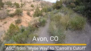
trail: Avon Singletree Connector
3:34 |
47 |
Aug 13, 2025 , Avon
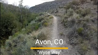
trail: Wyse Way
5:08 |
50 |
Aug 11, 2025 , Avon
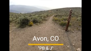
trail: PB & J
4:33 |
36 |
Aug 11, 2025 , Avon
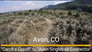
trail: Avon Singletree Connector
3:49 |
31 |
Aug 11, 2025 , Avon

trail: Carroll's Cutoff
3:49 |
41 |
Aug 11, 2025 , Avon
Current Trail Warnings
| status | trail | date | condition | user | info |
|---|---|---|---|---|---|
| Eastern Hillside | Jun 21, 2026 @ 12:03am (America/Los_Angeles) Jun 21, 2026 | Unknown | trailforks Trailforks |
Recent Trail Reports
| status | trail | date | condition | info | user |
|---|---|---|---|---|---|
| Village To Village (Middle) | Jul 1, 2026 @ 12:03am (America/Los_Angeles) 2 days | Unknown | trailforks Trailforks | ||
| Village To Village | Jul 1, 2026 @ 12:03am (America/Los_Angeles) 2 days | Unknown | trailforks Trailforks | ||
| Upper Moose | Jul 1, 2026 @ 12:03am (America/Los_Angeles) 2 days | Unknown | trailforks Trailforks | ||
| Rose Pedal | Jul 1, 2026 @ 12:03am (America/Los_Angeles) 2 days | Unknown | trailforks Trailforks | ||
| Rose Pedal | Jul 1, 2026 @ 12:03am (America/Los_Angeles) 2 days | Unknown | trailforks Trailforks | ||
| Primrose Road | Jul 1, 2026 @ 12:03am (America/Los_Angeles) 2 days | Unknown | trailforks Trailforks | ||
| Primrose Ridge | Jul 1, 2026 @ 12:03am (America/Los_Angeles) 2 days | Unknown | trailforks Trailforks | ||
| Primerose to Village | Jul 1, 2026 @ 12:03am (America/Los_Angeles) 2 days | Unknown | trailforks Trailforks | ||
| Mud Springs | Jul 1, 2026 @ 12:03am (America/Los_Angeles) 2 days | Unknown | trailforks Trailforks | ||
| Moose | Jul 1, 2026 @ 12:03am (America/Los_Angeles) 2 days | Unknown | trailforks Trailforks |
Activity Feed
| username | action | type | title | date |
|---|---|---|---|---|
| trailforks | add | report | activity #98182574 and 15 more | Jul 1, 2026 @ 12:03am 2 days |
| neb-nagrah | add | report | activity #98041764 | Jun 28, 2026 @ 7:53pm Jun 28, 2026 |
| DHonky | wishlist | trail | activity #97804349 | Jun 25, 2026 @ 5:29pm Jun 25, 2026 |
| KevMc | ridden | trail | activity #97620788 | Jun 23, 2026 @ 5:58am Jun 23, 2026 |
| Loulouq | wishlist | route | activity #97592087 | Jun 22, 2026 @ 4:45pm Jun 22, 2026 |
Recent Comments
| username | type | title | comment | date |
|---|---|---|---|---|
| trail | I use this as a climbing trail 3 times a week.... | Jun 7, 2026 @ 1:51pm Jun 7, 2026 | ||
| trail | Trail was cleared and redone a couple years... | Nov 3, 2025 @ 12:26pm Nov 3, 2025 | ||
| trail | Boring | Oct 30, 2025 @ 12:46am Oct 30, 2025 | ||
| trail | Sept 2025, horse only | Sep 28, 2025 @ 4:24pm Sep 28, 2025 | ||
| trail | needs a lot of things but signage aint one of em | Aug 21, 2025 @ 11:45am Aug 21, 2025 |
Local Badges
-

10 Blue Trails230 awarded -

Epic Ride Climb 2k65 awarded -

Climbing 10k Badge99 awarded -

Climbing 100k Badge6 awarded -

Epic Ride Descent 2k112 awarded -

Descent 10k Badge104 awarded
Local Trail Supporters
![Eagle Vail Metro District]()
![Axis Sports Medicine]()
![Walking Mountains Science Center]()
- Vail Spinners and Skinners & The Wolffe Tasting House
![Vail Mountain Employees]()
- Wyse Family
![Sonnenalp Club]()
![Form Attainment Studio]()
Activity Type Stats
| activitytype | trails | distance | descent | descent distance | total vertical | rating | global rank | state rank | photos | reports | routes | ridelogs |
|---|---|---|---|---|---|---|---|---|---|---|---|---|
| Mountain Bike | 52 | 77 miles | 21,532 ft | 41 miles | 3,205 ft | #1,699 | #632 | 155 | 1,302 | 2 | 16,042 | |
| E-Bike | 35 | 45 miles | 9,603 ft | 21 miles | 2,956 ft | #1,668 | #889 | 13 | 917 | 1 | 417 | |
| Horse | 10 | 14 miles | 2,608 ft | 4 miles | 3,698 ft | #2,002 | #1,118 | 488 | ||||
| Hike | 59 | 84 miles | 21,962 ft | 42 miles | 3,907 ft | #751 | #345 | 125 | 1,326 | 1 | 1,409 | |
| Trail Running | 59 | 84 miles | 21,962 ft | 42 miles | 3,907 ft | #2,312 | #709 | 1,326 | 1 | 1,211 | ||
| Dirtbike/Moto | 3 | 2 miles | 200 ft | 1 mile | 190 ft | #1,216 | #493 | 453 | 7 | |||
| ATV/ORV/OHV | 3 | 2 miles | 200 ft | 1 mile | 190 ft | #949 | #440 | 453 | ||||
| Snowshoe | 6 | 8 miles | 410 ft | 1 mile | 3,629 ft | #330 | #88 | 38 | 1 | 74 | ||
| Downhill Ski | 3 | 4,469 ft | 538 ft | 4,114 ft | 3,091 ft | 20 | 153 | |||||
| Backcountry Ski | 5 | 7 miles | 266 ft | 4,288 ft | 3,629 ft | #247 | #43 | 36 | 534 | |||
| Nordic Ski | 4 | 1 mile | 256 ft | 3,871 ft | 853 ft | #436 | #126 | 36 | 172 |
Frequently Asked Questions About Avon
▼
What are the best places to ride in Avon?
Avon has 2 areas to explore for mountain biking. The top rated areas are:
▼
What are the highest rated mountain biking trails in Avon?
The highest rated mountain biking trails in Avon are:
- Lee's Way Down (4.4/5)
- Beaver Lake Trail (4.3/5)
- Arrowhead Mountain to Mud Springs (4.2/5)
- PB & J (4.2/5)
- Paulies Plunge (4.2/5)
▼
What is the best time of the year to ride in Avon?
Based on ride log data, the most popular months to ride in Avon are:
- July (203 activities)
- August (122 activities)
- June (92 activities)
▼
Where can I park to ride in Avon?
There are 7 parking locations listed in Avon. The most popular parking spots are:
- West Avon Preserve Trailhead Parking
- June Creek Trailhead Parking
- Everkrisp / Stone Creek / Paulie's Plunge Parking
- Eastern Hillside Parking
- Arrowhead Trails Parking
Activities
Trails
Points of Interest
- By canadaka
 Trailforks & contributors
 - Admins: VVMTA
- #4955 - 9,753 views
- avon activity log | embed map of Avon mountain bike trails | avon mountain biking points of interest
Downloading of trail gps tracks in kml & gpx formats is enabled for Avon.
You must login to download files.