close
-
Layers w
- Weather Layers
- Pro
- Pro
- Pro
- Pro
- Pro
- Pro
- More Layers
- Pro
- Pro
- Pro
- Pro
-
Upgrade to

3D
Trail Conditions
- Unknown
- Snow Groomed
- Snow Packed
- Snow Covered
- Snow Cover Partial
- Freeze/thaw Cycle
- Icy
- Prevalent Mud
- Wet
- Variable
- Ideal
- Dry
- Very Dry
Trail Flow (Ridden Direction)
Trailforks scans users ridelogs to determine the most popular direction each trail is ridden. A good flowing trail network will have most trails flowing in a single direction according to their intension.
The colour categories are based on what percentage of riders are riding a trail in its intended direction.
The colour categories are based on what percentage of riders are riding a trail in its intended direction.
- > 96%
- > 90%
- > 80%
- > 70%
- > 50%
- < 50%
- bi-directional trail
- no data
Trail Last Ridden
Trailforks scans ridelogs to determine the last time a trail was ridden.
- < 2 days
- < 1 week
- < 2 weeks
- < 1 month
- < 6 months
- > 6 months
Trail Ridden Direction
The intended direction a trail should be ridden.
- Downhill Only
- Downhill Primary
- Both Directions
- Uphill Primary
- Uphill Only
- One Direction
Contribute Details
Colors indicate trail is missing specified detail.
- Description
- Photos
- Description & Photos
- Videos
Trail Popularity ?
Trailforks scans ridelogs to determine which trails are ridden the most in the last 9 months.
Trails are compared with nearby trails in the same city region with a possible 25 colour shades.
Think of this as a heatmap, more rides = more kinetic energy = warmer colors.
- most popular
- popular
- less popular
- not popular
ATV/ORV/OHV Filter
Max Vehicle Width
inches
US Cell Coverage
Legend

Radar Time
Activity Recordings
Trailforks uses anonymized public activity data.
?
Activity Recordings
Trailforks uses anonymized public activity data.
?
Personal Heatmap
▶
Activity Types
all
/
none
▶
Options
2
Date range
month
–
Winter Trails
Warning
A routing network for winter maps does not exist. Selecting trails using the winter trails layer has been disabled.
Missing Trails
Most Popular
Least Popular
Trails are colored based on popularity. The more popular a trail is, the more red. Less popular trails trend towards green.
Jump Magnitude Heatmap
Heatmap of where riders jump on trails. Zoom in to see individual jumps, click circles to view jump details.
BC Backroad Status
![map legend]()
Service Road Atlas is a free to use, community-driven service for viewing and creating reports on the numerous back-country service roads around B.C. and Alberta.

Slope Aspect
Direction the slope faces
Trails Deemphasized
Trails are shown in grey.
Only show trails with no bike usage.
Suggested Layers
Based on selected activity type
Save the current map location and zoom level as your default home location whenever this page is loaded.
SaveThe Codgers Mountain Bike Park is handily placed in the heart of Nelson and contains a wide range of mountain bike trails, from easy meandering single track for beginners and families to enjoy to full on double black downhill trails best left to the experts. The trails are based around three hills, with the summits rising to approximately 400m.
 google parking directions
 Access Info:
Brook st car park
Links
Activities Click to view
- Mountain Bike
28 trails
- E-Bike
11 trails
- Hike
22 trails
- Trail Running
22 trails
Region Details
- 7
- 1
- 4
- 1
Region Status
Open as of Jun 5, 2026Stats
- Avg Trail Rating
- Trails (view details)
- 19
- Trails Mountain Bike
- 30
- Trails E-Bike
- 11
- Trails Hike
- 22
- Trails Trail Running
- 22
- Total Distance
- 13 miles
- Total Descent
- 2,819 ft
- Total Vertical
- 1,058 ft
- Highest Trailhead
- 1,130 ft
- Reports
- 1,487
- Photos
- 121
- Ridden Counter
- 22,700
Popular Codgers Mountain Biking Trails
• 100 ★ 3.4 • 2,388 ft • 307 ft • 1,537 •
Trail Grade updated 2021. Primarily a climbing trail that gives access to the start of the descending routes in the area. These include , , , Top Dog, , Hot Box etc. Chur Jack.
• 100 ★ 3.5 • 1,324 ft • 27 ft • 1,516 •
Short easy link Trail to return to Andrews Field or Brook Street/Dun Trail entrance. New trail grade in 2021.
• 100 ★ 4.4 • 1,421 ft • 115 ft • 1,386 •
Climbing trail from the Dun Mountain Trail to Jacks Hub. Leading to , Jacks Track, then onto , and the Maitai Trails
• 95 ★ 4.3 • 2 miles • 39 ft • 1,343 •
Iconic and arguably Nelsons most popular trail for good reason. New trail grade in 2021.
• 100 ★ 4.0 • 2,480 ft • 3 ft • 1,340 •
A short flowing family grade 4 - rollers, berms, table tops. Starts at 'Jack's Hub' at the top of s, crosses the Dun Trail and finishes at the start of . New trail grade in 2021
• 85 ★ 4.2 • 1 mile • 65 ft • 958 •
Rebuilt in March 2018 this flowing singletrack is part flow trail and part old school. Some fun little jumps and berms, with some more mellow sections. . New trail grade in 2021
• 100 ★ 1.5 • 778 ft • 60 ft • 860 •
Popular blue difficulty dirt/gravel road. This multi-use trail can be used both directions. On average it takes 1 minutes to complete this trail.
Codgers Mountain Bike Routes
Pick & Mix Featured
20 miles • 4,603 ft • 45 • Loop •
Approx Ride Time: 3-4.5 Hours including stops. Permits: Permits are required, see...
Ollie's Choice Featured
15 miles • 3,974 ft • 22 •
Head skywards to Fringe then duck, dive and dodge down Black Diamond, Sunrise and Peaking. Bonus climb to...
17 miles • 4,176 ft • 8 •
Head skywards to Fringe then duck, dive and dodge down Black Diamond, Sunrise and Peaking. Bonus climb to...
19 miles • 5,260 ft • 12 • Loop •
Good way to ride both codgers and sharlands while getting in some of better value trails
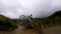
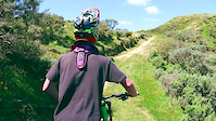
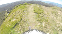
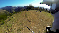
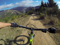
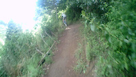
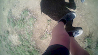
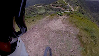
Photos of Codgers Mountain Bike
Videos of Codgers Mountain Bike
trail: Crazy Horse
0:59 |
994 |
Jul 31, 2017
trail: Gully
0:29 |
2169 |
Oct 26, 2014
trail: Gully
2:57 |
278 |
Oct 8, 2014
trail: Firball
4:06 |
698 |
Sep 30, 2014
trail: Firball
3:48 |
528 |
Jun 9, 2014
trail: Firball
0:49 |
171 |
Jan 16, 2014
trail: Firball
5:00 |
173 |
Jan 16, 2014
trail: Gully
3:14 |
371 |
Dec 9, 2013
Recent Trail Reports
| status | trail | date | condition | info | user |
|---|---|---|---|---|---|
| Firball Drop Out | Jun 2, 2026 @ 8:15pm (Pacific/Auckland) Jun 2, 2026 | Ideal | NMTBC NMTBC | ||
| Firball | Jun 2, 2026 @ 8:15pm (Pacific/Auckland) Jun 2, 2026 | Ideal | NMTBC NMTBC | ||
| Te Tirohanga Whetū o Koata (Koata Whetū) | May 22, 2026 @ 9:29am (Pacific/Auckland) May 21, 2026 | Ideal | NMTBC NMTBC | ||
| Young Codgers | May 6, 2026 @ 4:15pm (Pacific/Auckland) May 5, 2026 | Ideal | Love4riding WGTV | ||
| Crazy Horse | May 6, 2026 @ 4:15pm (Pacific/Auckland) May 5, 2026 | Ideal | Love4riding WGTV | ||
| Codgers Hub Link | Apr 4, 2026 @ 10:29am (Pacific/Auckland) Apr 3, 2026 | Ideal | Love4riding WGTV | ||
| Container Skid | Mar 23, 2026 @ 5:36pm (Pacific/Auckland) Mar 22, 2026 | Ideal | Love4riding WGTV | ||
| Pipeline | Mar 23, 2026 @ 5:36pm (Pacific/Auckland) Mar 22, 2026 | Ideal | Love4riding WGTV | ||
| Jacks Track (lower) | Mar 23, 2026 @ 5:36pm (Pacific/Auckland) Mar 22, 2026 | Ideal | Love4riding WGTV | ||
| Tantragee Road | Mar 17, 2026 @ 4:44pm (Pacific/Auckland) Mar 16, 2026 | Dry | Karahee |
Activity Feed
| username | action | type | title | date |
|---|---|---|---|---|
| OllieMTBSILVANMCGAZZA | add | photo | activity #96787205 | Jun 11, 2026 @ 11:44pm 21 hours |
| NMTBC | add | report | activity #96068087 and 1 more | Jun 2, 2026 @ 1:15am Jun 2, 2026 |
| NMTBC | add | report | activity #96040922 and 1 more | Jun 1, 2026 @ 2:27pm Jun 1, 2026 |
| NMTBC | add | report | activity #95200806 | May 21, 2026 @ 2:29pm May 21, 2026 |
| NMTBC | add | report | activity #94996028 | May 18, 2026 @ 1:08pm May 18, 2026 |
Recent Comments
| username | type | title | comment | date |
|---|---|---|---|---|
| trail | Just hit the track with my mate. The table is... | Oct 6, 2025 @ 11:44pm Oct 6, 2025 | ||
| trail | Rebuilt 2025. Weird flow trail with berms that... | Oct 5, 2025 @ 11:17pm Oct 5, 2025 | ||
| trail | Fun flowy trail, heaps of jumps / rollers... | Aug 26, 2025 @ 10:06pm Aug 26, 2025 | ||
| trail | Really fun flow trail. No idea why it’s a G4... | Mar 27, 2025 @ 4:18pm Mar 27, 2025 | ||
| trail | Grade 4, what a joke, it's an easy grade 3 at... | Feb 22, 2025 @ 7:07pm Feb 22, 2025 |
Nearby Areas
| name | distance | ||||
|---|---|---|---|---|---|
| Koata Park (formerly Maitai-Codgers) | 3 | 7 | 3 | 0.4 km | |
| The Grampians | 1 | 3 | 1.4 km | ||
| Fringed Hill Nelson | 4 | 9 | 2 km | ||
| Coppermine | 2 | 2.2 km | |||
| Waitarake/Sharlands | 2 | 7 | 4 | 2.5 km |
Local Badges
-

Completionist0 awarded
Activity Type Stats
| activitytype | trails | distance | descent | descent distance | total vertical | rating | global rank | state rank | photos | reports | routes | ridelogs |
|---|---|---|---|---|---|---|---|---|---|---|---|---|
| Mountain Bike | 28 | 13 miles | 2,818 ft | 6 miles | 1,060 ft | #551 | #21 | 122 | 1,491 | 10 | 25,949 | |
| E-Bike | 11 | 6 miles | 1,772 ft | 3 miles | 981 ft | #1,536 | #47 | 1,282 | 4 | 2,616 | ||
| Hike | 22 | 10 miles | 1,089 ft | 3 miles | 856 ft | #3,266 | #53 | 1,383 | 127 | |||
| Trail Running | 22 | 10 miles | 1,089 ft | 3 miles | 856 ft | #2,296 | #34 | 1,383 | 1,287 |
Frequently Asked Questions About Codgers
▼
What are the highest rated mountain biking trails in Codgers?
The highest rated mountain biking trails in Codgers are:
- Firball (4.2/5)
- Tasman Journeys (4.2/5)
- P51 (4.1/5)
- Te Tirohanga Whetū o Koata (Koata Whetū) (4/5)
- Whanake (4/5)
▼
What is the best time of the year to ride in Codgers?
Based on ride log data, the most popular months to ride in Codgers are:
- December (94 activities)
- January (94 activities)
- November (85 activities)
▼
Where can I park to ride in Codgers?
There are 3 parking locations listed in Codgers. The most popular parking spots are: View all parking and trailhead locations on the map to plan your visit.
▼
What is the longest trail in Codgers?
The longest trail in Codgers is Maitai Walkway at 3.9 km. View all trails sorted by distance.
Activities
- By bradical9 & contributors
- Admins: Aorere-Enduro, NelsonCouncil, NMTBC, tamallama
- #6653 - 46,120 views
- codgers activity log | embed map of Codgers mountain bike trails | codgers mountain biking points of interest polygons
Downloading of trail gps tracks in kml & gpx formats is enabled for Codgers.
You must login to download files.