close
-
Layers w
- Weather Layers
- Pro
- Pro
- Pro
- Pro
- Pro
- Pro
- More Layers
- Pro
- Pro
- Pro
- Pro
-
Upgrade to

3D
Trail Conditions
- Unknown
- Snow Groomed
- Snow Packed
- Snow Covered
- Snow Cover Partial
- Freeze/thaw Cycle
- Icy
- Prevalent Mud
- Wet
- Variable
- Ideal
- Dry
- Very Dry
Trail Flow (Ridden Direction)
Trailforks scans users ridelogs to determine the most popular direction each trail is ridden. A good flowing trail network will have most trails flowing in a single direction according to their intension.
The colour categories are based on what percentage of riders are riding a trail in its intended direction.
The colour categories are based on what percentage of riders are riding a trail in its intended direction.
- > 96%
- > 90%
- > 80%
- > 70%
- > 50%
- < 50%
- bi-directional trail
- no data
Trail Last Ridden
Trailforks scans ridelogs to determine the last time a trail was ridden.
- < 2 days
- < 1 week
- < 2 weeks
- < 1 month
- < 6 months
- > 6 months
Trail Ridden Direction
The intended direction a trail should be ridden.
- Downhill Only
- Downhill Primary
- Both Directions
- Uphill Primary
- Uphill Only
- One Direction
Contribute Details
Colors indicate trail is missing specified detail.
- Description
- Photos
- Description & Photos
- Videos
Trail Popularity ?
Trailforks scans ridelogs to determine which trails are ridden the most in the last 9 months.
Trails are compared with nearby trails in the same city region with a possible 25 colour shades.
Think of this as a heatmap, more rides = more kinetic energy = warmer colors.
- most popular
- popular
- less popular
- not popular
ATV/ORV/OHV Filter
Max Vehicle Width
inches
US Cell Coverage
Legend

Radar Time
Activity Recordings
Trailforks uses anonymized public activity data.
?
Activity Recordings
Trailforks uses anonymized public activity data.
?
Personal Heatmap
▶
Activity Types
all
/
none
▶
Options
2
Date range
month
–
Winter Trails
Warning
A routing network for winter maps does not exist. Selecting trails using the winter trails layer has been disabled.
Missing Trails
Most Popular
Least Popular
Trails are colored based on popularity. The more popular a trail is, the more red. Less popular trails trend towards green.
Jump Magnitude Heatmap
Heatmap of where riders jump on trails. Zoom in to see individual jumps, click circles to view jump details.
BC Backroad Status
![map legend]()
Service Road Atlas is a free to use, community-driven service for viewing and creating reports on the numerous back-country service roads around B.C. and Alberta.

Slope Aspect
Direction the slope faces
Trails Deemphasized
Trails are shown in grey.
Only show trails with no bike usage.
Suggested Layers
Based on selected activity type
Save the current map location and zoom level as your default home location whenever this page is loaded.
SaveThis area has a high density of trails for all ability levels and serves as the unofficial hub of mountain bike activity in the South Shore. Out here you will find the most legal features including log rides, jumps and rock rolls in South Tahoe including the new jumps, berms, rollers and hips TAMBA and SBTS built in 2014. The trails all run parallel to the Fountain Place paved road so they can be shuttled by car. Or with only moderate climbing involved these trails can keep almost anyone interested for hours. You can find everyone out here having fun from people in body armor and downhill bikes to families testing their kids limits to xc racer types riding intervals.
Primary Trail Type: All-Mountain & Downhill
Shuttleable: YES
Land Status: National Forest
 google parking directions
 Activities Click to view
- Mountain Bike
16 trails
- E-Bike
12 trails
- Horse
13 trails
- Hike
15 trails
- Trail Running
15 trails
- Dirtbike/Moto
9 trails
- ATV/ORV/OHV
8 trails
Region Details
- 4
- 4
- 6
- 2
Region Status
Open as of May 22, 2026Stats
- Avg Trail Rating
- Trails (view details)
- 16
- Trails Mountain Bike
- 16
- Trails E-Bike
- 12
- Trails Horse
- 13
- Trails Hike
- 15
- Trails Trail Running
- 15
- Trails Dirtbike/Moto
- 9
- Trails Observed Trials
- 3
- Trails ATV/ORV/OHV
- 8
- Total Distance
- 17 miles
- Total Descent
- 2,812 ft
- Total Vertical
- 1,399 ft
- Highest Trailhead
- 7,681 ft
- Reports
- 694
- Photos
- 204
- Ridden Counter
- 20,287
Popular Corral Mountain Biking Trails
• 100 ★ 4.9 • 1 mile • 15 ft • 2,963 •
With a slew of berms, rollers, hips, and table top jumps, has been a signature project built by TAMBA in partnership with the Forest Service since 2014. The first build was in 2014 with subsequent builds in 2015 and 2017. Out here you...
• 100 ★ 4.9 • 3,563 ft • 0 ft • 2,488 •
is a rough rocky trail with tight banked turns and many optional jumps and drops.
• 100 ★ 4.9 • 2 miles • 0 ft • 2,306 •
is a challenging and fast trail with epic vistas. This trail has three distinct sections. The upper section is largely flat in dense trees with tight turns and several optional log rides. The middle section is rocky, fast, often sandy,...
• 100 ★ 4.6 • 1 mile • 16 ft • 1,545 •
Sidewinder is well named and features dozens of moderately banked turns which double back on each other creating a ride that feels like something from an amusement park. Bike handling skills will be tested because of the density of...
• 100 ★ 4.3 • 2 miles • 44 ft • 1,204 •
traverses a comstock-era railroad grade adjacent to Trout Creek and is an essentially flat, straight trail. It provides excellent access into the Corral network of trails, but is also an excellent trail for beginner single track riders....
• 100 ★ 4.7 • 2 miles • 82 ft • 1,005 •
The easiest trail in the Corral system, Incense Cedar winds gently alongside Lower Corral Trail featuring some berms and optional rock rolls. If you are looking to climb singletrack rather than paved road, this trail is a great option...
• 95 ★ 5.0 • 3,301 ft • 23 ft • 676 •
Popular green difficulty singletrack. This mountain bike primary trail can be used both directions. On average it takes 2 minutes to complete this trail.
• 95 ★ 5.0 • 2,505 ft • 36 ft • 496 •
Popular green difficulty singletrack. This mountain bike primary trail can be used both directions and has a easy overall physical rating. On average it takes 2 minutes to complete this trail.
Corral Mountain Bike Routes
★ 5.0 • 5 miles • 755 ft • 2 • Loop •
Climb up to the top of Upper Corral. This descends Upper and Lower Corral. Easier option is to descend...
★ 4.5 • 26 miles • 4,490 ft • 13 • Loop •
26-mile ride with almost 100% singletrack, two summits and amazing descents. Lots of tecnical singletrack...
★ 4.0 • 20 miles • 3,223 ft • 26 •
For 2019, the Tahoe Triple Crown Ride has transformed into a butterfly. TAMBA & USFS have been monitoring...
33 miles • 4,569 ft • 11 • Loop •
A more challenging technical approach to Heavenly TRT. Ride up the scenic Van Sickle trail, into Heavenly....
★ 2.5 • 10 miles • 1,263 ft • 9 • Loop •
This loop circumnavigates Waterhouse Peak. Most of the riding is moderate but there are a few technical...
7 miles • 666 ft • 4 • Loop •
Lake Tahoe has tons of great trails for all levels. If you’re not quite ready for the Tahoe Triple...
Photos of Corral Mountain Bike
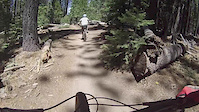
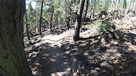
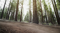
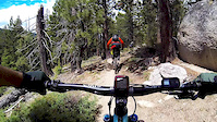
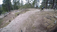
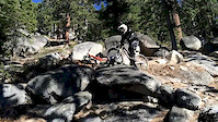
Videos of Corral Mountain Bike
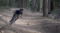
trail: Corral Trail (Lower)
0:20 |
473 |
Aug 15, 2017
trail: Corral Trail (Lower)
2:00 |
256 |
Aug 3, 2016
trail: Armstrong Connector Trail
4:35 |
82 |
Jul 13, 2016
trail: Corral Trail (Upper)
0:15 |
313 |
Apr 22, 2016
trail: Armstrong Connector Trail
2:03 |
428 |
Jul 13, 2015
trail: Corral Trail (Lower)
8:20 |
277 |
Apr 8, 2015
trail: Corral Trail (Lower)
0:02 |
454 |
Oct 20, 2014
youtuber
![Corral (post-Caldor Fire) / South Lake Tahoe /...]()
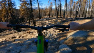
trail: Corral Trail (Upper)
6:02 |
55 |
Nov 27, 2021 , South Lake Tahoe
Recent Trail Reports
Activity Feed
| username | action | type | title | date |
|---|---|---|---|---|
| ConnoriEVQhL | ridden | trail | activity #96991207 | Jun 14, 2026 @ 11:42am Jun 14, 2026 |
| nturin | wishlist | route | activity #96970331 | Jun 14, 2026 @ 8:12am Jun 14, 2026 |
| akonthetrails | wishlist | route | activity #96818466 | Jun 12, 2026 @ 11:35am Jun 12, 2026 |
| spanky123 | wishlist | route | activity #96769722 | Jun 11, 2026 @ 4:53pm Jun 11, 2026 |
| b1tghost | wishlist | trail | activity #96716560 | Jun 10, 2026 @ 8:46pm Jun 10, 2026 |
Recent Comments
| username | type | title | comment | date |
|---|---|---|---|---|
| trail | This is NOT an uphill route. Take the road or... | Jun 1, 2026 @ 1:43pm Jun 1, 2026 | ||
| trail | This is NOT an uphill route. Take the road. | Jun 1, 2026 @ 1:34pm Jun 1, 2026 | ||
| trail | This is NOT an uphill route. Take the road. | Jun 1, 2026 @ 1:34pm Jun 1, 2026 | ||
| trail | Amazing | Aug 4, 2025 @ 7:04pm Aug 4, 2025 | ||
| report | Will do | Jul 23, 2025 @ 9:45pm Jul 23, 2025 |
Nearby Areas
| name | distance | ||||
|---|---|---|---|---|---|
| SLT Urban Trails | 22 | 1 | 1.9 km | ||
| Powerline | 5 | 3 | 1 | 2.2 km | |
| Freel High Country | 5 | 5 | 2.7 km | ||
| Meyers Urban Trails | 28 | 10 | 3.1 km | ||
| Hartoonian Trails | 27 | 3.1 km |
Activity Type Stats
| activitytype | trails | distance | descent | descent distance | total vertical | rating | global rank | state rank | photos | reports | routes | ridelogs |
|---|---|---|---|---|---|---|---|---|---|---|---|---|
| Mountain Bike | 16 | 17 miles | 2,812 ft | 9 miles | 1,401 ft | #958 | #353 | 204 | 691 | 12 | 15,203 | |
| E-Bike | 12 | 13 miles | 1,985 ft | 6 miles | 1,365 ft | #3,843 | #1,092 | 1 | 622 | 5 | 1,766 | |
| Horse | 13 | 16 miles | 2,690 ft | 8 miles | 1,401 ft | #1,785 | #940 | 393 | 1 | |||
| Hike | 15 | 17 miles | 2,812 ft | 9 miles | 1,401 ft | #8,419 | #3,159 | 690 | 148 | |||
| Trail Running | 15 | 17 miles | 2,812 ft | 9 miles | 1,401 ft | #7,649 | #2,583 | 690 | 135 | |||
| Dirtbike/Moto | 9 | 13 miles | 1,985 ft | 6 miles | 1,365 ft | #847 | #350 | 336 | 2 | 9 | ||
| Observed Trials | 3 | 4 miles | 974 ft | 3 miles | 650 ft | 60 | ||||||
| ATV/ORV/OHV | 8 | 12 miles | 1,585 ft | 5 miles | 1,365 ft | #589 | #257 | 293 | 2 |
Frequently Asked Questions About Corral
▼
What are the highest rated mountain biking trails in Corral?
The highest rated mountain biking trails in Corral are:
- Corral Trail (Lower) (4.8/5)
- Corral Trail (Upper) (4.8/5)
- Armstrong Connector Trail (4.7/5)
- Incense Cedar Trail (4.5/5)
- Sierra Sidewinder Trail (4.5/5)
▼
What is the best time of the year to ride in Corral?
Based on ride log data, the most popular months to ride in Corral are:
- July (349 activities)
- June (276 activities)
- May (240 activities)
▼
Where can I park to ride in Corral?
There are 1 parking locations listed in Corral. The most popular parking spots are:
▼
What is the longest trail in Corral?
The longest trail in Corral is Armstrong Connector Trail at 1.8 miles. View all trails sorted by distance.
Activities
- By pedrodelmonte
 & contributors
 - Admins: TAMBA, TRTA, TAMBA
- #20238 - 9,961 views
- corral activity log | embed map of Corral mountain bike trails | corral mountain biking points of interest
Downloading of trail gps tracks in kml & gpx formats is enabled for Corral.
You must login to download files.