close
-
Layers w
- Weather Layers
- Pro
- Pro
- Pro
- Pro
- Pro
- Pro
- More Layers
- Pro
- Pro
- Pro
- Pro
-
Upgrade to

3D
Trail Conditions
- Unknown
- Snow Groomed
- Snow Packed
- Snow Covered
- Snow Cover Partial
- Freeze/thaw Cycle
- Icy
- Prevalent Mud
- Wet
- Variable
- Ideal
- Dry
- Very Dry
Trail Flow (Ridden Direction)
Trailforks scans users ridelogs to determine the most popular direction each trail is ridden. A good flowing trail network will have most trails flowing in a single direction according to their intension.
The colour categories are based on what percentage of riders are riding a trail in its intended direction.
The colour categories are based on what percentage of riders are riding a trail in its intended direction.
- > 96%
- > 90%
- > 80%
- > 70%
- > 50%
- < 50%
- bi-directional trail
- no data
Trail Last Ridden
Trailforks scans ridelogs to determine the last time a trail was ridden.
- < 2 days
- < 1 week
- < 2 weeks
- < 1 month
- < 6 months
- > 6 months
Trail Ridden Direction
The intended direction a trail should be ridden.
- Downhill Only
- Downhill Primary
- Both Directions
- Uphill Primary
- Uphill Only
- One Direction
Contribute Details
Colors indicate trail is missing specified detail.
- Description
- Photos
- Description & Photos
- Videos
Trail Popularity ?
Trailforks scans ridelogs to determine which trails are ridden the most in the last 9 months.
Trails are compared with nearby trails in the same city region with a possible 25 colour shades.
Think of this as a heatmap, more rides = more kinetic energy = warmer colors.
- most popular
- popular
- less popular
- not popular
ATV/ORV/OHV Filter
Max Vehicle Width
inches
US Cell Coverage
Legend

Radar Time
Activity Recordings
Trailforks uses anonymized public activity data.
?
Activity Recordings
Trailforks uses anonymized public activity data.
?
Personal Heatmap
▶
Activity Types
all
/
none
▶
Options
2
Date range
month
–
Winter Trails
Warning
A routing network for winter maps does not exist. Selecting trails using the winter trails layer has been disabled.
Missing Trails
Most Popular
Least Popular
Trails are colored based on popularity. The more popular a trail is, the more red. Less popular trails trend towards green.
Jump Magnitude Heatmap
Heatmap of where riders jump on trails. Zoom in to see individual jumps, click circles to view jump details.
BC Backroad Status
![map legend]()
Service Road Atlas is a free to use, community-driven service for viewing and creating reports on the numerous back-country service roads around B.C. and Alberta.

Slope Aspect
Direction the slope faces
Trails Deemphasized
Trails are shown in grey.
Only show trails with no bike usage.
Suggested Layers
Based on selected activity type
Save the current map location and zoom level as your default home location whenever this page is loaded.
Save
No description for Cuenca has been added yet!
Login or register to submit one.
This region uses the Uk/Euro style trail grading system.
Activities Click to view
- Mountain Bike
836 trails
- E-Bike
833 trails
- Gravel Bike
1 trails
- Adaptive Bike
0 trails
- Horse
13 trails
- Hike
841 trails
- Trail Running
838 trails
- Dirtbike/Moto
4 trails
Region Details
- 555
- 36
- 205
- 38
- 2
Region Status
Caution as of Oct 5, 2025Dirtbike/Moto Stats
- Global Ranking
- #739
- State Ranking
- #38
- Trails (view details)
- 4
- Trails Mountain Bike
- 836
- Trails E-Bike
- 833
- Trails Gravel Bike
- 1
- Trails Horse
- 13
- Trails Hike
- 841
- Trails Trail Running
- 838
- Trails Dirtbike/Moto
- 4
- Trails ATV/ORV/OHV
- 3
- Total Distance
- 5 miles
- Total Descent Distance
- 2 miles
- Total Descent
- 259 ft
- Total Vertical
- 338 ft
- Reports
- 28
Popular Cuenca Dirtbiking Trails
Recent Ride Log Activity in Region
Today
- 0 dirtbike rides
Yesterday
- 0 dirtbike rides
Past Week
- 0 dirtbike rides
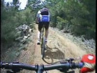
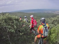
Photos of Cuenca
Videos of Cuenca

46:26 |
68 |
Dec 22, 2024 , Cuenca

trail: La Losa
46:26 |
81 |
Dec 22, 2024 , Cuenca

trail: Los Hocinos
46:26 |
60 |
Dec 22, 2024 , Cuenca
3:14 |
90 |
May 27, 2023

3:58 |
116 |
May 27, 2023
trail: Del B12
3:15 |
91 |
May 27, 2023 , Cuenca

trail: Grederos
3:53 |
95 |
May 27, 2023 , Cuenca

trail: Mira Baja
3:53 |
97 |
May 27, 2023 , Cuenca
Recent Trail Reports
no previous reports, add one now!
Activity Feed
| username | action | type | title | date |
|---|---|---|---|---|
| dmeier6233 | add | karma | activity #89411952 | Feb 23, 2026 @ 7:01am Feb 23, 2026 |
| trailforks | add | report | activity #49465482 and 7 more | Feb 24, 2024 @ 12:04am Feb 24, 2024 |
| montonm | add | report | activity #49063230 and 9 more | Feb 11, 2024 @ 4:10am Feb 11, 2024 |
| montonm | add | report | activity #49035477 and 14 more | Feb 10, 2024 @ 8:33am Feb 10, 2024 |
| montonm | update | trail | activity #39926132 and 18 more | May 13, 2023 @ 9:12am May 13, 2023 |
Activity Type Stats
| activitytype | trails | distance | descent | descent distance | total vertical | rating | global rank | state rank | photos | reports | routes | ridelogs |
|---|---|---|---|---|---|---|---|---|---|---|---|---|
| Mountain Bike | 836 | 782 miles | 130,253 ft | 410 miles | 2,828 ft | #198 | #27 | 87 | 406 | 9 | 3,082 | |
| E-Bike | 833 | 780 miles | 130,108 ft | 410 miles | 2,828 ft | #25 | #22 | 403 | 6 | 346 | ||
| Gravel Bike | 1 | #388 | #79 | 27 | 1 | 10 | ||||||
| Horse | 13 | 23 miles | 3,543 ft | 11 miles | 1,247 ft | #1,359 | #101 | 28 | ||||
| Hike | 841 | 784 miles | 131,181 ft | 411 miles | 2,828 ft | #69 | #22 | 406 | 114 | 235 | ||
| Trail Running | 838 | 784 miles | 131,181 ft | 411 miles | 2,828 ft | #46 | #19 | 406 | 545 | |||
| Dirtbike/Moto | 4 | 5 miles | 259 ft | 2 miles | 338 ft | #739 | #38 | 28 | ||||
| ATV/ORV/OHV | 3 | 5 miles | 259 ft | 2 miles | 338 ft | 28 |
Frequently Asked Questions About Cuenca
▼
What are the best places to ride in Cuenca?
Cuenca has 12 areas to explore for dirtbiking.
▼
What are the highest rated dirtbiking trails in Cuenca?
The highest rated dirtbiking trails in Cuenca are:
- Motocross (0/5)
▼
Where can I park to ride in Cuenca?
There are 1 parking locations listed in Cuenca.
▼
What is the longest trail in Cuenca?
The longest trail in Cuenca is Motocross at 2,034 ft. View all trails sorted by distance.
Activities
Trails
- By sbrarturo & contributors
- Admins: AMG, Kalamarrrrrdo, not-really, montonm
- #8706 - 3,711 views
- cuenca activity log | embed map of Cuenca mountain bike trails | cuenca mountain biking points of interest
Downloading of trail gps tracks in kml & gpx formats is enabled for Cuenca.
You must login to download files.