close
-
Layers w
- Weather Layers
- Pro
- Pro
- Pro
- Pro
- Pro
- Pro
- More Layers
- Pro
- Pro
- Pro
- Pro
-
Upgrade to

3D
Trail Conditions
- Unknown
- Snow Groomed
- Snow Packed
- Snow Covered
- Snow Cover Partial
- Freeze/thaw Cycle
- Icy
- Prevalent Mud
- Wet
- Variable
- Ideal
- Dry
- Very Dry
Trail Flow (Ridden Direction)
Trailforks scans users ridelogs to determine the most popular direction each trail is ridden. A good flowing trail network will have most trails flowing in a single direction according to their intension.
The colour categories are based on what percentage of riders are riding a trail in its intended direction.
The colour categories are based on what percentage of riders are riding a trail in its intended direction.
- > 96%
- > 90%
- > 80%
- > 70%
- > 50%
- < 50%
- bi-directional trail
- no data
Trail Last Ridden
Trailforks scans ridelogs to determine the last time a trail was ridden.
- < 2 days
- < 1 week
- < 2 weeks
- < 1 month
- < 6 months
- > 6 months
Trail Ridden Direction
The intended direction a trail should be ridden.
- Downhill Only
- Downhill Primary
- Both Directions
- Uphill Primary
- Uphill Only
- One Direction
Contribute Details
Colors indicate trail is missing specified detail.
- Description
- Photos
- Description & Photos
- Videos
Trail Popularity ?
Trailforks scans ridelogs to determine which trails are ridden the most in the last 9 months.
Trails are compared with nearby trails in the same city region with a possible 25 colour shades.
Think of this as a heatmap, more rides = more kinetic energy = warmer colors.
- most popular
- popular
- less popular
- not popular
ATV/ORV/OHV Filter
Max Vehicle Width
inches
US Cell Coverage
Legend

Radar Time
Activity Recordings
Trailforks uses anonymized public activity data.
?
Activity Recordings
Trailforks uses anonymized public activity data.
?
Personal Heatmap
▶
Activity Types
all
/
none
▶
Options
2
Date range
month
–
Winter Trails
Warning
A routing network for winter maps does not exist. Selecting trails using the winter trails layer has been disabled.
Missing Trails
Most Popular
Least Popular
Trails are colored based on popularity. The more popular a trail is, the more red. Less popular trails trend towards green.
Jump Magnitude Heatmap
Heatmap of where riders jump on trails. Zoom in to see individual jumps, click circles to view jump details.
BC Backroad Status
![map legend]()
Service Road Atlas is a free to use, community-driven service for viewing and creating reports on the numerous back-country service roads around B.C. and Alberta.

Slope Aspect
Direction the slope faces
Trails Deemphasized
Trails are shown in grey.
Only show trails with no bike usage.
Suggested Layers
Based on selected activity type
Save the current map location and zoom level as your default home location whenever this page is loaded.
Save
No description for Enumclaw has been added yet!
Login or register to submit one.
Activities Click to view
- Mountain Bike
9 trails
- Gravel Bike
0 trails
- Adaptive Bike
0 trails
- Winter Fat Bike
0 trails
- Hike
18 trails
- Trail Running
18 trails
Region Details
- 2
- 2
- 5
Region Status
Caution as of Feb 22, 2026Local Trail Association
Hike Stats
- Global Ranking
- #5,796
- State Ranking
- #2,038
- Trails (view details)
- 18
- Trails Mountain Bike
- 10
- Trails Hike
- 18
- Trails Trail Running
- 18
- Total Distance
- 32 miles
- Total Descent Distance
- 10 miles
- Total Descent
- 4,042 ft
- Total Vertical
- 2,749 ft
- Reports
- 45
- Photos
- 3
- Ridden Counter
- 339
Sub Regions
-
Green River Gorge
-
Mud Mountain
- 2
- 2
-
Nolte State Park
-
Pinnacle Peak Park
Popular Enumclaw Hiking Trails
• 100 ★ 0.0 • 3,812 ft • 823 ft • 88 • • hike
Blue difficulty singletrack. This hike primary trail can be used both directions.
• 95 ★ 0.0 • 2 miles • 1,058 ft • 83 • • hike
Blue difficulty singletrack. This hike primary trail can be used both directions. On average it takes 57 minutes to complete this trail.
• 80 ★ 0.0 • 1,404 ft • 115 ft • 45 • • hike
Green difficulty singletrack. This hike primary trail can be used both directions. On average it takes 6 minutes to complete this trail.
• 90 ★ 0.0 • 509 ft • 2 ft • 39 • • hike
Green difficulty singletrack. This hike primary trail can be used both directions.
• 75 ★ 0.0 • 1,535 ft • 204 ft • 32 • • hike
Blue difficulty singletrack. This hike primary trail can be used both directions. On average it takes 4 minutes to complete this trail.
• 85 ★ 0.0 • 3,143 ft • 821 ft • 24 • • hike
Blue difficulty singletrack. This hike primary trail can be used both directions. On average it takes 23 minutes to complete this trail.
• 70 ★ 0.0 • 1 mile • 61 ft • 11 • • hike
Blue difficulty singletrack. This hike primary trail can be used both directions.
• 65 ★ 1.0 • 3,596 ft • 0 ft • 7 • • hike
Steep downhill from the road, trail width varies from sidewalk down to single track and there are many logs to hop over / dodge under.
Enumclaw Routes
3 miles • 1,056 ft • 2 • Loop •
• 2 miles • 1,110 ft • 2 •
• 2 miles • 1,372 ft • 2 •
• 1 mile • 1,089 ft • 1 •
• 3 miles • 240 ft • 3 •
• 2 miles • 1,006 ft • 4 •
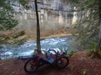
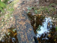
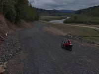
Photos of Enumclaw
Videos of Enumclaw
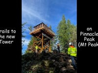
trail: Pinnacle Peak Trail
6:01 |
106 |
Dec 6, 2023 , Enumclaw
trail: Rim Trail
5:55 |
153 |
Feb 28, 2024 , Enumclaw
trail: access road
4:13 |
90 |
Dec 3, 2023 , Enumclaw
trail: access road
3:23 |
227 |
Dec 3, 2023 , Enumclaw
trail: Hanging Garden Trails
3:53 |
439 |
Dec 3, 2023 , Enumclaw
trail: Rim Trail
5:07 |
191 |
Dec 2, 2023 , Enumclaw
trail: River Trail
3:18 |
147 |
Dec 2, 2023 , Enumclaw
Recent Trail Reports
| status | trail | date | condition | info | user |
|---|---|---|---|---|---|
| Cal Magnusson Trail | Feb 22, 2026 @ 12:29pm (America/Los_Angeles) Feb 22, 2026 | Ideal | marebearrr | ||
| South Side | Feb 22, 2026 @ 12:29pm (America/Los_Angeles) Feb 22, 2026 | Ideal | marebearrr | ||
| Pinnacle Peak Trail | Feb 22, 2026 @ 12:29pm (America/Los_Angeles) Feb 22, 2026 | Ideal | marebearrr | ||
| River Trail | Dec 1, 2025 @ 10:49am (America/Los_Angeles) Dec 1, 2025 | Ideal | marebearrr | ||
| Bog Trail | Dec 1, 2025 @ 10:49am (America/Los_Angeles) Dec 1, 2025 | Ideal | marebearrr | ||
| Rim Trail | Nov 22, 2025 @ 1:25pm (America/Los_Angeles) Nov 22, 2025 | Ideal | marebearrr | ||
| Goat Trail Alt. | Sep 29, 2025 @ 12:29pm (America/Los_Angeles) Sep 29, 2025 | Ideal | marebearrr | ||
| Goat Trail | Sep 29, 2025 @ 12:29pm (America/Los_Angeles) Sep 29, 2025 | Ideal | marebearrr | ||
| Rim Trail | Apr 20, 2025 @ 3:46pm Apr 20, 2025 | Ideal | marebearrr | ||
| Nolte State Park Trail | Jan 7, 2023 @ 10:23am Jan 7, 2023 | Unknown | allaroundjoe |
Activity Feed
| username | action | type | title | date |
|---|---|---|---|---|
| marebearrr | add | report | activity #89384520 and 2 more | Feb 22, 2026 @ 2:33pm Feb 22, 2026 |
| marebearrr | add | report | activity #85027960 and 1 more | Dec 1, 2025 @ 1:23pm Dec 1, 2025 |
| marebearrr | add | report | activity #84572754 and 1 more | Nov 22, 2025 @ 5:01pm Nov 22, 2025 |
| Mrchris42 | comment | trail | activity #82463987 | Oct 16, 2025 @ 1:00pm Oct 16, 2025 |
| dread98230 | wishlist | trail | activity #82277599 | Oct 13, 2025 @ 9:36am Oct 13, 2025 |
Recent Comments
| username | type | title | comment | date |
|---|---|---|---|---|
| trail | This trail no longer exists, at least from the... | Oct 16, 2025 @ 1:00pm Oct 16, 2025 | ||
| report | It does stop at river trail. There’s no... | Apr 20, 2025 @ 3:48pm Apr 20, 2025 | ||
| trail | Two hiking only trails intersect part way up... | Dec 6, 2023 @ 7:03am Dec 6, 2023 | ||
| report | And the second half is completely gone | Aug 7, 2021 @ 9:51am Aug 7, 2021 |
Local Badges
-

Epic Hike Climb 2k2 awarded -

Climbing 10k Badge1 awarded -

Hiking 100k Badge0 awarded -

Big Hike 10k29 awarded -

Epic Hike 50k1 awarded -

10 Blue Trails1 awarded
Activity Type Stats
| activitytype | trails | distance | descent | descent distance | total vertical | rating | global rank | state rank | photos | reports | routes | ridelogs |
|---|---|---|---|---|---|---|---|---|---|---|---|---|
| Mountain Bike | 9 | 27 miles | 3,930 ft | 10 miles | 2,749 ft | #9,492 | #2,974 | 34 | 43 | 1,840 | ||
| Hike | 18 | 32 miles | 4,042 ft | 10 miles | 2,749 ft | #5,796 | #2,038 | 3 | 45 | 1 | 1,134 | |
| Trail Running | 18 | 32 miles | 4,042 ft | 10 miles | 2,749 ft | #5,723 | #1,823 | 45 | 567 |
Frequently Asked Questions About Enumclaw
▼
What are the best places to hike in Enumclaw?
Enumclaw has 4 areas to explore for hiking. The top rated areas are:
▼
What are the highest rated hiking trails in Enumclaw?
The highest rated hiking trails in Enumclaw are:
- Cal Magnusson Trail (0/5)
- Pinnacle Peak Trail (0/5)
- Goat Trail Alt. (0/5)
- Goat Trail (0/5)
- South Side (0/5)
▼
What is the best time of the year to hike in Enumclaw?
Based on ride log data, the most popular months to hike in Enumclaw are:
- January (5 activities)
- September (4 activities)
- June (2 activities)
▼
Where can I park to hike in Enumclaw?
There are 7 parking locations listed in Enumclaw. The most popular parking spots are: View all parking and trailhead locations on the map to plan your visit.
Trails
- By palzer
 & contributors
 - Admins: EBTC, EMBA-C2S, EMBA-C2S
- #5947 - 6,611 views
- enumclaw activity log | embed map of Enumclaw mountain bike trails | enumclaw mountain biking points of interest
Downloading of trail gps tracks in kml & gpx formats is enabled for Enumclaw.
You must login to download files.