close
-
Layers w
- Weather Layers
- Pro
- Pro
- Pro
- Pro
- Pro
- Pro
- More Layers
- Pro
- Pro
- Pro
- Pro
-
Upgrade to

3D
Trail Conditions
- Unknown
- Snow Groomed
- Snow Packed
- Snow Covered
- Snow Cover Partial
- Freeze/thaw Cycle
- Icy
- Prevalent Mud
- Wet
- Variable
- Ideal
- Dry
- Very Dry
Trail Flow (Ridden Direction)
Trailforks scans users ridelogs to determine the most popular direction each trail is ridden. A good flowing trail network will have most trails flowing in a single direction according to their intension.
The colour categories are based on what percentage of riders are riding a trail in its intended direction.
The colour categories are based on what percentage of riders are riding a trail in its intended direction.
- > 96%
- > 90%
- > 80%
- > 70%
- > 50%
- < 50%
- bi-directional trail
- no data
Trail Last Ridden
Trailforks scans ridelogs to determine the last time a trail was ridden.
- < 2 days
- < 1 week
- < 2 weeks
- < 1 month
- < 6 months
- > 6 months
Trail Ridden Direction
The intended direction a trail should be ridden.
- Downhill Only
- Downhill Primary
- Both Directions
- Uphill Primary
- Uphill Only
- One Direction
Contribute Details
Colors indicate trail is missing specified detail.
- Description
- Photos
- Description & Photos
- Videos
Trail Popularity ?
Trailforks scans ridelogs to determine which trails are ridden the most in the last 9 months.
Trails are compared with nearby trails in the same city region with a possible 25 colour shades.
Think of this as a heatmap, more rides = more kinetic energy = warmer colors.
- most popular
- popular
- less popular
- not popular
ATV/ORV/OHV Filter
Max Vehicle Width
inches
US Cell Coverage
Legend

Radar Time
Activity Recordings
Trailforks uses anonymized public activity data.
?
Activity Recordings
Trailforks uses anonymized public activity data.
?
Personal Heatmap
▶
Activity Types
all
/
none
▶
Options
2
Date range
month
–
Winter Trails
Warning
A routing network for winter maps does not exist. Selecting trails using the winter trails layer has been disabled.
Missing Trails
Most Popular
Least Popular
Trails are colored based on popularity. The more popular a trail is, the more red. Less popular trails trend towards green.
Jump Magnitude Heatmap
Heatmap of where riders jump on trails. Zoom in to see individual jumps, click circles to view jump details.
BC Backroad Status
![map legend]()
Service Road Atlas is a free to use, community-driven service for viewing and creating reports on the numerous back-country service roads around B.C. and Alberta.

Slope Aspect
Direction the slope faces
Trails Deemphasized
Trails are shown in grey.
Only show trails with no bike usage.
Suggested Layers
Based on selected activity type
Save the current map location and zoom level as your default home location whenever this page is loaded.
Save
No description for Glenwild has been added yet!
Login or register to submit one.
 google parking directions

google parking directions
IMBA Ride Center
Park City
Activities Click to view
- Mountain Bike
30 trails
- Hike
28 trails
- Trail Running
28 trails
Region Details
- 5
- 1
- 1
- 21
- 2
Region Status
Open as of Jun 14, 2026Stats
- Avg Trail Rating
- Trails (view details)
- 32
- Trails Mountain Bike
- 31
- Trails E-Bike
- 3
- Trails Hike
- 28
- Trails Trail Running
- 28
- Total Distance
- 51 miles
- Total Descent
- 7,023 ft
- Total Vertical
- 1,956 ft
- Highest Trailhead
- 7,766 ft
- Reports
- 1,802
- Photos
- 233
- Ridden Counter
- 47,912
Popular Glenwild Mountain Biking Trails
• 100 ★ 3.2 • 4,783 ft • 252 ft • 3,690 •
Not uphill only but plenty of other down only trails in the area means this is only ever ridden in the uphill direction. Heavily used. Winds through low brush. Some climbing turns and easy rock gardens.
• 100 ★ 3.9 • 1 mile • 196 ft • 3,672 •
This trail connects Bob’s basin to the loop. It has high desert riding like Mucha Bob basin, but with some Fast flowing good dirt, fun babyhead rocks, gamble-oak, and a single aspen section.
• 95 ★ 4.6 • 4 miles • 269 ft • 3,663 •
is a great Park City trail that's off the typical Park City beaten path. Fun and challenging singletrack with great views. is typically done counterclockwise.
• 100 ★ 4.4 • 4,633 ft • 0 ft • 2,889 •
This trail has been completely redone over the summer of 2019. It now has much larger berms, more jumps, larger gap-able roller doubles, and small drops.
• 60 ★ 3.9 • 6 miles • 824 ft • 2,789 •
Can get pretty rocky in some sections. Not much shade. Don't ride this trail around midday unless you want to get sunburnt.
• 85 ★ 3.4 • 2 miles • 179 ft • 2,451 •
Popular blue difficulty singletrack. This multi-use trail can be used both directions. Adaptive MTB rating: amtb blue. On average it takes 13 minutes to complete this trail.
• 95 ★ 3.1 • 3,474 ft • 0 ft • 2,396 •
Short trail to and from Creekside lot to access trails. Beautiful to return at sunset with the winding creek below.
• 80 ★ 4.0 • 2 miles • 0 ft • 2,362 •
This is a really stiff climb. It winds through the trees and has several steep switchbacks that can get to be a bit loose. This is mostly used as a climb because of the fast flowing fun down to the Beaver Dam. But make sure you are...
Glenwild Mountain Bike Routes
★ 5.0 • 14 miles • 1,889 ft • 5 •
Short loop, skipping the section and adding in a Bob's Basin DH trail.
★ 4.0 • 8 miles • 1,246 ft • 3 • Loop •
A short version of that starting in the neighborhood.
13 miles • 1,762 ft • 4 • Loop •
The Best Day Ride Series, brought to you by Park City Bike Racing and sponsored by Best Day Brewing, is...
14 miles • 1,915 ft • 7 • Loop •
Lollypop route from TH. Up Fink, , anti-clockwise on , back to , over to Dropout and down.
4 miles • 573 ft • 2 •
A quick after work or early season loop. Great to get back into the things again or to go with a new rider...
Photos of Glenwild Mountain Bike
Videos of Glenwild Mountain Bike

trail: Flying Dog
0:13 |
377 |
Oct 18, 2020

trail: Team Cutthroat DH
0:14 |
863 |
Apr 4, 2012
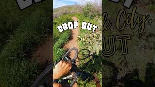
trail: The Drop Out
0:41 |
67 |
Jul 3, 2025 , Park City

trail: Ant Farm
0:41 |
117 |
Jul 1, 2025 , Park City
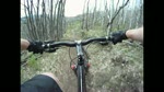
trail: Flying Dog
5:44 |
575 |
May 31, 2010
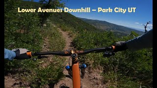
trail: The Avenue
4:34 |
254 |
Jul 31, 2022 , Park City

trail: Bad Apple
2:25 |
347 |
Jul 14, 2022 , Park City

trail: 24-7
10:52 |
397 |
Jul 12, 2022 , Park City
Current Trail Warnings
| status | trail | date | condition | user | info |
|---|---|---|---|---|---|
| Flying Dog | Jun 15, 2026 @ 10:50am (America/Denver) Jun 15, 2026 | Dry | lucaspie | Ruined from twisted fork trails festival.... | |
| 24-7 Access | May 28, 2026 @ 1:43pm (America/Denver) May 28, 2026 | Freeze/thaw Cycle | brushfire |
Recent Trail Reports
| status | trail | date | condition | info | user |
|---|---|---|---|---|---|
| Sunrise Drive | Jun 14, 2026 @ 9:02am (America/Denver) Jun 14, 2026 | Dry | Ammopuke | ||
| Stealth | Jun 8, 2026 @ 7:28pm (America/Denver) Jun 8, 2026 | Dry | falcon013 | ||
| 24-7 | May 24, 2026 @ 10:20am (America/Boise) May 24, 2026 | Ideal | chilewings | ||
| Flying Dog | May 24, 2026 @ 10:20am (America/Boise) May 24, 2026 | Ideal | chilewings | ||
| Cobblestone Loop | May 24, 2026 @ 10:20am (America/Boise) May 24, 2026 | Unknown | chilewings | ||
| Cobblestone | May 24, 2026 @ 10:20am (America/Boise) May 24, 2026 | Ideal | chilewings | ||
| 24-7 | May 24, 2026 @ 10:20am (America/Boise) May 24, 2026 | Ideal | chilewings | ||
| Fink Again | May 24, 2026 @ 10:20am (America/Boise) May 24, 2026 | Ideal | chilewings | ||
| The Drop Out | May 20, 2026 @ 7:56am (America/Denver) May 20, 2026 | Ideal | utmtbrider | ||
| Team Cutthroat DH | May 20, 2026 @ 7:55am (America/Denver) May 20, 2026 | Ideal | utmtbrider |
Activity Feed
| username | action | type | title | date |
|---|---|---|---|---|
| IraB | wishlist | route | activity #97666268 | Jun 23, 2026 @ 6:22pm 19 hours |
| Ammopuke | add | report | activity #97156903 | Jun 16, 2026 @ 7:27pm Jun 16, 2026 |
| lucaspie | add | report | activity #97048402 | Jun 15, 2026 @ 9:50am Jun 15, 2026 |
| lucaspie | comment | trail | activity #97048209 | Jun 15, 2026 @ 9:47am Jun 15, 2026 |
| Helipirate86 | add | report | activity #97017079 | Jun 14, 2026 @ 6:17pm Jun 14, 2026 |
Recent Comments
| username | type | title | comment | date |
|---|---|---|---|---|
| trail | This trail is RUINED. Death rattles like... | Jun 15, 2026 @ 9:47am Jun 15, 2026 | ||
| trail | Big thanks to the race director that didnt... | Jun 3, 2026 @ 3:39pm Jun 3, 2026 | ||
| trail | Trail is 99% dry but there’s lots of... | Mar 19, 2026 @ 11:15am Mar 19, 2026 | ||
| trail | Climb up via Glenwild & Cobblestone was... | Mar 19, 2026 @ 11:14am Mar 19, 2026 | ||
| trail | All dry in good shape overall | Mar 19, 2026 @ 11:12am Mar 19, 2026 |
Nearby Areas
| name | distance | ||||
|---|---|---|---|---|---|
| Jeremy Ranch | 1.8 km | ||||
| Woodward Park City | 5 | 3 | 1 | 1 | 2.3 km |
| Utah Olympic Park | 7 | 16 | 3 | 2.4 km | |
| Trailside Park | 18 | 10 | 3 | 3.1 km | |
| Willow Creek Trails | 3 | 3.2 km |
Local Badges
-

Completionist1 awarded
Bike & Skill Parks
| name | type | city | rating |
|---|---|---|---|
| East Canyon Pumptrack | skill park | Park City |
Upcoming Local Events
Local Products
Local Products
Activity Type Stats
| activitytype | trails | distance | descent | descent distance | total vertical | rating | global rank | state rank | photos | reports | routes | ridelogs |
|---|---|---|---|---|---|---|---|---|---|---|---|---|
| Mountain Bike | 30 | 49 miles | 6,722 ft | 24 miles | 1,955 ft | #410 | #158 | 233 | 1,798 | 13 | 32,028 | |
| E-Bike | 3 | 5 miles | 92 ft | 1 mile | 128 ft | 1,309 | 622 | |||||
| Hike | 28 | 49 miles | 6,083 ft | 22 miles | 1,955 ft | #4,035 | #1,431 | 1,729 | 2 | 1,192 | ||
| Trail Running | 28 | 49 miles | 6,083 ft | 22 miles | 1,955 ft | #3,107 | #820 | 1,730 | 2 | 1,634 |
Frequently Asked Questions About Glenwild
▼
What are the highest rated mountain biking trails in Glenwild?
The highest rated mountain biking trails in Glenwild are:
- Flying Dog (4.5/5)
- The Drop Out (4.3/5)
- Ant Farm (4.1/5)
- Cobblestone Loop (4.1/5)
- Upper Avenues (4/5)
▼
What is the best time of the year to ride in Glenwild?
Based on ride log data, the most popular months to ride in Glenwild are:
- July (561 activities)
- June (492 activities)
- May (461 activities)
▼
Where can I park to ride in Glenwild?
There are 1 parking locations listed in Glenwild. The most popular parking spots are:
▼
What is the longest trail in Glenwild?
The longest trail in Glenwild is Glenwild at 5.8 miles. View all trails sorted by distance.
- By todd
 Trailforks & contributors
 - Admins: MTF, NAC, todd
- #4808 - 18,374 views
- glenwild activity log | embed map of Glenwild mountain bike trails | glenwild mountain biking points of interest
Downloading of trail gps tracks in kml & gpx formats is enabled for Glenwild.
You must login to download files.