close
-
Layers w
- Weather Layers
- Pro
- Pro
- Pro
- Pro
- Pro
- Pro
- More Layers
- Pro
- Pro
- Pro
- Pro
-
Upgrade to

3D
Trail Conditions
- Unknown
- Snow Groomed
- Snow Packed
- Snow Covered
- Snow Cover Partial
- Freeze/thaw Cycle
- Icy
- Prevalent Mud
- Wet
- Variable
- Ideal
- Dry
- Very Dry
Trail Flow (Ridden Direction)
Trailforks scans users ridelogs to determine the most popular direction each trail is ridden. A good flowing trail network will have most trails flowing in a single direction according to their intension.
The colour categories are based on what percentage of riders are riding a trail in its intended direction.
The colour categories are based on what percentage of riders are riding a trail in its intended direction.
- > 96%
- > 90%
- > 80%
- > 70%
- > 50%
- < 50%
- bi-directional trail
- no data
Trail Last Ridden
Trailforks scans ridelogs to determine the last time a trail was ridden.
- < 2 days
- < 1 week
- < 2 weeks
- < 1 month
- < 6 months
- > 6 months
Trail Ridden Direction
The intended direction a trail should be ridden.
- Downhill Only
- Downhill Primary
- Both Directions
- Uphill Primary
- Uphill Only
- One Direction
Contribute Details
Colors indicate trail is missing specified detail.
- Description
- Photos
- Description & Photos
- Videos
Trail Popularity ?
Trailforks scans ridelogs to determine which trails are ridden the most in the last 9 months.
Trails are compared with nearby trails in the same city region with a possible 25 colour shades.
Think of this as a heatmap, more rides = more kinetic energy = warmer colors.
- most popular
- popular
- less popular
- not popular
ATV/ORV/OHV Filter
Max Vehicle Width
inches
US Cell Coverage
Legend

Radar Time
Activity Recordings
Trailforks uses anonymized public activity data.
?
Activity Recordings
Trailforks uses anonymized public activity data.
?
Personal Heatmap
▶
Activity Types
all
/
none
▶
Options
2
Date range
month
–
Winter Trails
Warning
A routing network for winter maps does not exist. Selecting trails using the winter trails layer has been disabled.
Missing Trails
Most Popular
Least Popular
Trails are colored based on popularity. The more popular a trail is, the more red. Less popular trails trend towards green.
Jump Magnitude Heatmap
Heatmap of where riders jump on trails. Zoom in to see individual jumps, click circles to view jump details.
BC Backroad Status
![map legend]()
Service Road Atlas is a free to use, community-driven service for viewing and creating reports on the numerous back-country service roads around B.C. and Alberta.

Slope Aspect
Direction the slope faces
Trails Deemphasized
Trails are shown in grey.
Only show trails with no bike usage.
Suggested Layers
Based on selected activity type
Save the current map location and zoom level as your default home location whenever this page is loaded.
Save
No description for Granada has been added yet!
Login or register to submit one.
This region uses the Uk/Euro style trail grading system.
Activities Click to view
- Mountain Bike
524 trails
- E-Bike
528 trails
- Horse
16 trails
- Hike
540 trails
- Trail Running
537 trails
- Dirtbike/Moto
2 trails
- ATV/ORV/OHV
0 trails
- Downhill Ski
125 trails
Region Details
- 224
- 1
- 16
- 192
- 81
- 8
Stats
- Avg Trail Rating
- Trails (view details)
- 674
- Trails Mountain Bike
- 524
- Trails E-Bike
- 528
- Trails Gravel Bike
- 205
- Trails Adaptive Bike
- 18
- Trails Horse
- 16
- Trails Hike
- 540
- Trails Trail Running
- 537
- Trails Dirtbike/Moto
- 2
- Trails Downhill Ski
- 125
- Total Distance
- 723 miles
- Total Descent
- 235,832 ft
- Total Vertical
- 11,017 ft
- Highest Trailhead
- 11,366 ft
- Reports
- 302
- Photos
- 128
- Ridden Counter
- 13,718
Articles
Video: The Final 8 Head to Granada in YT Mob World Tour Episode 7
Nov 28, 2019 from pinkbike.com
The 8 Golden Ticket riders head to the Mob HQ for a final shakedown.
Sub Regions
- Almuñécar (1)
- Baza (30)
- Desierto de Gorafe (5)
- P.N Sierra de Baza (23)
- Granada (230)
- Alpujarra (63)
- Dehesa del Generalife (26)
- Dílar (13)
- La Zubia (3)
- Sierra de Huetor (35)
- Sierra Elvira (16)
- Sierra Nevada (15)
- Huéscar (2)
- Motril (133)
- Bullarenga (63)
- El Conjuro (24)
- Velez de Benaudalla (41)
- Centro BTT Nevada (33)
- Güéjar Sierra (50)
- Velez de Benaudalla (2)
Popular Granada Mountain Biking Trails
• 100 ★ 4.5 • 2,595 ft • 0 ft • 119 •
Sin ciclar pero con rastros de calor y track de otras plataformas...se agradece comentario si la ciclas, Gracias
• 100 ★ 4.0 • 709 ft • 0 ft • 118 •
Sin ciclar pero con rastros de calor y track de otras plataformas...se agradece comentario si la ciclas, Gracias
• 100 ★ 4.0 • 1,850 ft • 0 ft • 117 •
Sin ciclar pero con rastros de calor y track de otras plataformas...se agradece comentario si la ciclas, Gracias
• 100 ★ 4.0 • 1 mile • 7 ft • 116 •
Popular blue difficulty singletrack. This multi-use trail can be used downhill only. It features berm, drop, rock face and rock garden. On average it takes 14 minutes to complete this trail.
• 100 ★ 4.5 • 2 miles • 9 ft • 107 •
Popular blue difficulty singletrack. This multi-use trail can be used downhill primary. On average it takes 12 minutes to complete this trail.
• 90 ★ 4.5 • 2 miles • 10 ft • 102 •
Some rocky technical sections, exposed sections and loose terrain, be careful.
• 100 ★ 5.0 • 3,904 ft • 0 ft • 100 •
Popular blue difficulty singletrack. This multi-use trail can be used downhill only. It features berm, rock garden and roller coaster. Trail visibility is always easy to follow. On average it takes 5 minutes to complete this trail.
Granada Mountain Bike Routes
6 miles • 1,762 ft • 3 • Loop •
Preciosa ruta , con una primera parte de subida por asfalto y toda la bajada por una trialera que quita el...
19 miles • 5,320 ft • 10 • Loop •
Ruta aprovechando parte de las bajadas de la zona, intentando maximizar el trazado dentro de la distancia...
25 miles • 5,846 ft • 12 • Loop •
Ruta endurera por las Alpujarras. Es una ruta que puede dejarte la batería seca si tienes 625 W/h si no...
16 miles • 3,526 ft • 9 • Loop •
Segunda variante en la Sierra de Huétor, donde se realiza una trazada intentando no repetir las bajadas...
21 miles • 4,171 ft • 9 • Loop •
Ruta muy completa en la sierra de Huétor, donde se prioriza el trazado en la dirección de las bajadas...
10 miles • 3,544 ft • 6 • Loop •
Variante realizada dejando el coche en el llano junto a la presa y bajando por la carretera un tramo hasta...
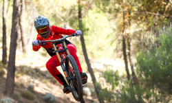
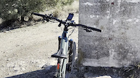
Photos of Granada Mountain Bike
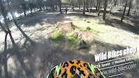
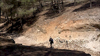
Videos of Granada Mountain Bike
trail: Vertice Cerro Gordo
2:34 |
|
Jan 29, 2023

trail: Conjuro-Garnatilla
3:40 |
152 |
Aug 1, 2021
trail: Panduro
3:19 |
386 |
Mar 12, 2019

trail: Panduro
0:40 |
6291 |
Aug 21, 2018
trail: Panduro
0:06 |
307 |
Apr 24, 2018
trail: Canal
0:16 |
105 |
Dec 30, 2017
trail: Panduro
0:40 |
2096 |
Feb 12, 2017
3:20 |
66607 |
Jul 12, 2016
Recent Trail Reports
| status | trail | date | condition | info | user |
|---|---|---|---|---|---|
| Acceso La Gitana Güéjar Sierra | Jun 21, 2026 @ 6:10pm (Europe/Madrid) Jun 21, 2026 | Unknown | FranciscoEAHnkJ | ||
| La Molineta Granada | May 14, 2026 @ 7:12am (Europe/Gibraltar) May 13, 2026 | Ideal | manexbal | ||
| Entre Sierras Granada | May 14, 2026 @ 7:12am (Europe/Gibraltar) May 13, 2026 | Ideal | manexbal | ||
| El Poyeton Motril | Apr 10, 2026 @ 11:04am (Europe/Madrid) Apr 10, 2026 | Unknown | AnderIXXX4H | ||
| 48 Curvas Velez de Benaudalla | Apr 5, 2026 @ 10:33am (Europe/Gibraltar) Apr 5, 2026 | Very Dry | TRUSTwfZQWW | ||
| Barranco de los Castillejos Alpujarra | Apr 5, 2026 @ 9:59am (Europe/Gibraltar) Apr 5, 2026 | Dry | TRUSTwfZQWW | ||
| King 2 Bullarenga | Feb 24, 2026 @ 2:23pm (Europe/Madrid) Feb 24, 2026 | Wet | Benjadh3 | ||
| Moby Dick Velez de Benaudalla | Feb 23, 2026 @ 8:52am (Europe/Madrid) Feb 22, 2026 | Ideal | MalagaRider | ||
| Superskung XL Velez de Benaudalla | Feb 20, 2026 @ 8:57pm (Europe/Madrid) Feb 20, 2026 | Ideal | josillescas | ||
| Barranco de Malacabí La Zubia | Feb 16, 2026 @ 2:35pm (Europe/Madrid) Feb 16, 2026 | Unknown | thormikel |
Activity Feed
| username | action | type | title | date |
|---|---|---|---|---|
| AMG | update | region | activity #97769381 | Jun 25, 2026 @ 8:11am Jun 25, 2026 |
| AMG | add | trail | activity #97769370 and 4 more | Jun 25, 2026 @ 8:10am Jun 25, 2026 |
| AMG | add | trail | activity #97754918 and 2 more | Jun 25, 2026 @ 2:03am Jun 25, 2026 |
| AMG | add | region | activity #97754786 | Jun 25, 2026 @ 1:58am Jun 25, 2026 |
| AMG | add | trail | activity #97754058 and 11 more | Jun 25, 2026 @ 1:27am Jun 25, 2026 |
Recent Comments
| username | type | title | comment | date |
|---|---|---|---|---|
| trail | One of the moste enjoyable trails around ,... | May 29, 2026 @ 12:18am May 29, 2026 | ||
| trail | Last part of Secret Garden, aka Keep it... | May 29, 2026 @ 12:16am May 29, 2026 | ||
| trail | One of the most flowy trails around the area,... | May 29, 2026 @ 12:14am May 29, 2026 | ||
| trail | Lo hice sólo hasta el giro cerrado de 180º... | Apr 5, 2026 @ 1:12am Apr 5, 2026 | ||
| trail | Sendero 100% ciclable pero con mucho sube-baja... | Mar 31, 2026 @ 3:43am Mar 31, 2026 |
Local Badges
-

Epic Ride Descent 2k304 awarded -

Big Ride 30k1,033 awarded -

Descent 100k Badge5 awarded -

Descent 10k Badge52 awarded -

Epic Ride 50k539 awarded -

Mountain Biking 100k Badge5 awarded
Bike & Skill Parks
| name | type | city | rating |
|---|---|---|---|
| Baza motocross | skill park | Baza | |
| Salobreña motocross | skill park | Motril | |
| Cuevas del campo motocross | skill park | Baza |
Activity Type Stats
| activitytype | trails | distance | descent | descent distance | total vertical | rating | global rank | state rank | photos | reports | routes | ridelogs |
|---|---|---|---|---|---|---|---|---|---|---|---|---|
| Mountain Bike | 524 | 607 miles | 174,882 ft | 342 miles | 10,722 ft | 117 | 302 | 36 | 23,689 | |||
| E-Bike | 528 | 608 miles | 177,323 ft | 344 miles | 10,722 ft | 2 | 246 | 33 | 3,885 | |||
| Gravel Bike | 205 | 327 miles | 43,484 ft | 143 miles | 8,924 ft | 8 | 1 | 137 | ||||
| Adaptive Bike | 18 | 19 miles | 1,578 ft | 7 miles | 4,997 ft | |||||||
| Horse | 16 | 21 miles | 1,480 ft | 9 miles | 2,352 ft | 41 | ||||||
| Hike | 540 | 643 miles | 185,640 ft | 357 miles | 11,017 ft | 7 | 298 | 92 | 2,129 | |||
| Trail Running | 537 | 640 miles | 185,784 ft | 356 miles | 11,017 ft | 298 | 37 | 470 | ||||
| Dirtbike/Moto | 2 | 6 miles | 1,302 ft | 3 miles | 2,815 ft | 34 | 6 | |||||
| Downhill Ski | 125 | 65 miles | 47,680 ft | 57 miles | 3,822 ft | 554 |
Frequently Asked Questions About Granada
▼
What are the best places to ride in Granada?
Granada has 15 areas to explore for mountain biking. The top rated areas are:
▼
What are the highest rated mountain biking trails in Granada?
The highest rated mountain biking trails in Granada are:
- Conjuro-Garnatilla (4.4/5)
- Las Viñas (4.4/5)
- Toro (4.3/5)
- Conjuro 2 (4.3/5)
- La Llanada (4.3/5)
▼
What is the best time of the year to ride in Granada?
Based on ride log data, the most popular months to ride in Granada are:
- October (96 activities)
- April (51 activities)
- January (46 activities)
▼
What is the longest trail in Granada?
The longest trail in Granada is Acequia del Fardes at 4.3 miles. View all trails sorted by distance.
Activities
Trails
Points of Interest
- By brenthillier
 NSMBA TRAILFORKS & contributors
 - Admins: mul0w, elyari, AMG, juanx, Angelreing, AMG, juanx
- #8835 - 7,939 views
- granada activity log | embed map of Granada mountain bike trails | granada mountain biking points of interest
Downloading of trail gps tracks in kml & gpx formats is enabled for Granada.
You must login to download files.