close
-
Layers w
- Weather Layers
- Pro
- Pro
- Pro
- Pro
- Pro
- Pro
- More Layers
- Pro
- Pro
- Pro
- Pro
-
Upgrade to

3D
Trail Conditions
- Unknown
- Snow Groomed
- Snow Packed
- Snow Covered
- Snow Cover Partial
- Freeze/thaw Cycle
- Icy
- Prevalent Mud
- Wet
- Variable
- Ideal
- Dry
- Very Dry
Trail Flow (Ridden Direction)
Trailforks scans users ridelogs to determine the most popular direction each trail is ridden. A good flowing trail network will have most trails flowing in a single direction according to their intension.
The colour categories are based on what percentage of riders are riding a trail in its intended direction.
The colour categories are based on what percentage of riders are riding a trail in its intended direction.
- > 96%
- > 90%
- > 80%
- > 70%
- > 50%
- < 50%
- bi-directional trail
- no data
Trail Last Ridden
Trailforks scans ridelogs to determine the last time a trail was ridden.
- < 2 days
- < 1 week
- < 2 weeks
- < 1 month
- < 6 months
- > 6 months
Trail Ridden Direction
The intended direction a trail should be ridden.
- Downhill Only
- Downhill Primary
- Both Directions
- Uphill Primary
- Uphill Only
- One Direction
Contribute Details
Colors indicate trail is missing specified detail.
- Description
- Photos
- Description & Photos
- Videos
Trail Popularity ?
Trailforks scans ridelogs to determine which trails are ridden the most in the last 9 months.
Trails are compared with nearby trails in the same city region with a possible 25 colour shades.
Think of this as a heatmap, more rides = more kinetic energy = warmer colors.
- most popular
- popular
- less popular
- not popular
ATV/ORV/OHV Filter
Max Vehicle Width
inches
US Cell Coverage
Legend

Radar Time
Activity Recordings
Trailforks uses anonymized public activity data.
?
Activity Recordings
Trailforks uses anonymized public activity data.
?
Personal Heatmap
▶
Activity Types
all
/
none
▶
Options
2
Date range
month
–
Winter Trails
Warning
A routing network for winter maps does not exist. Selecting trails using the winter trails layer has been disabled.
Missing Trails
Most Popular
Least Popular
Trails are colored based on popularity. The more popular a trail is, the more red. Less popular trails trend towards green.
Jump Magnitude Heatmap
Heatmap of where riders jump on trails. Zoom in to see individual jumps, click circles to view jump details.
BC Backroad Status
![map legend]()
Service Road Atlas is a free to use, community-driven service for viewing and creating reports on the numerous back-country service roads around B.C. and Alberta.

Slope Aspect
Direction the slope faces
Trails Deemphasized
Trails are shown in grey.
Only show trails with no bike usage.
Suggested Layers
Based on selected activity type
Save the current map location and zoom level as your default home location whenever this page is loaded.
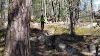
SaveProtected nature preservation area in Stockholm.
Primary Trail Type: Cross-Country
AKA: Grimsta
Land Status: Conservation Reserve
 google parking directions
This region uses the Uk/Euro style trail grading system.
Activities Click to view
- Mountain Bike
98 trails
- Hike
97 trails
- Trail Running
97 trails
Region Details
- 19
- 7
- 57
- 11
- 4
Region Status
Open as of Jul 4, 2026Stats
- Avg Trail Rating
- Trails (view details)
- 99
- Trails Mountain Bike
- 98
- Trails Horse
- 2
- Trails Hike
- 97
- Trails Trail Running
- 97
- Total Distance
- 22 miles
- Total Descent Distance
- 9 miles
- Total Descent
- 1,442 ft
- Total Vertical
- 127 ft
- Highest Trailhead
- 165 ft
- Reports
- 241
- Photos
- 19
- Ridden Counter
- 4,955
Popular Grimstaskogen Mountain Biking Trails
• 95 ★ 4.3 • 5 miles • 397 ft • 206 •
Technical and not so fast trail with a lot of roots and rocks.
• 95 ★ 5.0 • 791 ft • 0 ft • 96 •
Popular green difficulty singletrack. This multi-use trail can be used both directions and has a moderate overall physical rating with a 0 ft blue climb. Trail visibility is sometimes hard to follow. On average it takes minutes to complete this trail.
• 95 ★ 4.0 • 535 ft • 11 ft • 96 •
Popular blue difficulty singletrack. This multi-use trail can be used both directions and has a moderate overall physical rating with a 11 ft blue climb. Trail visibility is sometimes hard to follow. On average it takes minutes to complete this trail.
• 85 ★ 4.0 • 545 ft • 6 ft • 88 •
Popular blue difficulty singletrack. This mountain bike primary trail can be used both directions and has a moderate overall physical rating with a 6 ft blue climb. Trail visibility is sometimes hard to follow. On average it takes 2 minutes to complete this trail.
• 85 ★ 5.0 • 810 ft • 13 ft • 65 •
Popular blue difficulty singletrack. This multi-use trail can be used both directions and has a hard overall physical rating with a 13 ft black diamond climb. Trail visibility is sometimes hard to follow. On average it takes 5 minutes to complete this trail.
• 85 ★ 5.0 • 482 ft • 0 ft • 59 •
Popular blue difficulty singletrack. This multi-use trail can be used both directions and has a moderate overall physical rating with a 0 ft blue climb. Trail visibility is sometimes hard to follow. On average it takes 1 minutes to complete this trail.
• 90 ★ 5.0 • 482 ft • 0 ft • 59 •
Popular blue difficulty singletrack. This multi-use trail can be used both directions and has a moderate overall physical rating with a 0 ft black diamond climb. Trail visibility is sometimes hard to follow. On average it takes minutes to complete this trail.
• 85 ★ 5.0 • 978 ft • 57 ft • 54 •
A connection between "Stugängsvägen" and the " " Trail.
Photos of Grimstaskogen Mountain Bike
Videos of Grimstaskogen Mountain Bike
trail: Grimsta Access 1
0:05 |
184 |
May 16, 2020
Recent Trail Reports
| status | trail | date | condition | info | user |
|---|---|---|---|---|---|
| Över Ängen | Jul 4, 2026 @ 11:11am (Europe/Stockholm) Jul 4, 2026 | Variable | OrjanX TRAILFORKS | ||
| Över Stenarna | Jul 4, 2026 @ 11:11am (Europe/Stockholm) Jul 4, 2026 | Variable | OrjanX TRAILFORKS | ||
| Över Berget Till Stigen | Jul 4, 2026 @ 11:11am (Europe/Stockholm) Jul 4, 2026 | Variable | OrjanX TRAILFORKS | ||
| Vänstra Sidan | Jul 4, 2026 @ 11:11am (Europe/Stockholm) Jul 4, 2026 | Variable | OrjanX TRAILFORKS | ||
| Vänster Höger | Jul 4, 2026 @ 11:11am (Europe/Stockholm) Jul 4, 2026 | Variable | OrjanX TRAILFORKS | ||
| Vildmarksspåret | Jul 4, 2026 @ 11:11am (Europe/Stockholm) Jul 4, 2026 | Variable | OrjanX TRAILFORKS | ||
| Vid Sjön | Jul 4, 2026 @ 11:11am (Europe/Stockholm) Jul 4, 2026 | Variable | OrjanX TRAILFORKS | ||
| Vid Sidan Av Klippan | Jul 4, 2026 @ 11:11am (Europe/Stockholm) Jul 4, 2026 | Variable | OrjanX TRAILFORKS | ||
| Utkanten | Jul 4, 2026 @ 11:11am (Europe/Stockholm) Jul 4, 2026 | Variable | OrjanX TRAILFORKS | ||
| Utegymmet Grimsta | Jul 4, 2026 @ 11:11am (Europe/Stockholm) Jul 4, 2026 | Variable | OrjanX TRAILFORKS |
Activity Feed
| username | action | type | title | date |
|---|---|---|---|---|
| OrjanX | add | report | activity #98394769 and 111 more | Jul 4, 2026 @ 2:10am Jul 4, 2026 |
| mark_e | ridden | trail | activity #98134973 | Jun 30, 2026 @ 9:03am Jun 30, 2026 |
| mark_e | wishlist | trail | activity #98133375 | Jun 30, 2026 @ 8:40am Jun 30, 2026 |
| mark_e | add | report | activity #98133245 | Jun 30, 2026 @ 8:38am Jun 30, 2026 |
| mark_e | ridden | trail | activity #97978233 | Jun 28, 2026 @ 4:57am Jun 28, 2026 |
Recent Comments
| username | type | title | comment | date |
|---|---|---|---|---|
| trail | Helt fel gradering. Grönt eller blått | Oct 19, 2025 @ 5:00am Oct 19, 2025 | ||
| trail | Blött men inte så mycket lera. | Sep 2, 2020 @ 3:18am Sep 2, 2020 | ||
| trail | Fattade inte vart hoppet är, får försöka... | Jul 12, 2020 @ 10:04am Jul 12, 2020 | ||
| trail | Några roliga sträckor, men mest rotigt och... | Jul 9, 2017 @ 4:57pm Jul 9, 2017 |
Nearby Areas
| name | distance | ||||
|---|---|---|---|---|---|
| Södra Ängby - Blackeberg | 7 | 16 | 1.3 km | ||
| Norra Ängby | 1.7 km | ||||
| Lovön | 14 | 43 | 1.8 km | ||
| Judarskogen | 9 | 30 | 2 km | ||
| Kärsön | 2 | 3 | 2.7 km |
Local Badges
-

Completionist0 awarded
Activity Type Stats
| activitytype | trails | distance | descent | descent distance | total vertical | rating | global rank | state rank | photos | reports | routes | ridelogs |
|---|---|---|---|---|---|---|---|---|---|---|---|---|
| Mountain Bike | 98 | 22 miles | 1,417 ft | 9 miles | 128 ft | #2,227 | #69 | 19 | 241 | 8,908 | ||
| Horse | 2 | 3,520 ft | 49 ft | 1,503 ft | 66 ft | 25 | ||||||
| Hike | 97 | 22 miles | 1,434 ft | 9 miles | 128 ft | #4,696 | #185 | 241 | 78 | |||
| Trail Running | 97 | 22 miles | 1,434 ft | 9 miles | 128 ft | #3,055 | 241 | 1,654 |
Frequently Asked Questions About Grimstaskogen
▼
What are the highest rated mountain biking trails in Grimstaskogen?
The highest rated mountain biking trails in Grimstaskogen are:
- Vildmarksspåret (4.2/5)
- Branten (4.1/5)
- Klyftan (4.1/5)
- Ner Till Parkeringen (4.1/5)
- Grimsta Short Downhill (4.1/5)
▼
What is the best time of the year to ride in Grimstaskogen?
Based on ride log data, the most popular months to ride in Grimstaskogen are:
- August (55 activities)
- May (38 activities)
- July (38 activities)
▼
Where can I park to ride in Grimstaskogen?
There are 1 parking locations listed in Grimstaskogen. The most popular parking spots are:
▼
What is the longest trail in Grimstaskogen?
The longest trail in Grimstaskogen is Vildmarksspåret at 8.0 km. View all trails sorted by distance.
Activities
Trails
Points of Interest
- By monocles & contributors
- Admins: casparlarsson, ollesvenskonthetrail, OrjanX, Hulken, jnasslander, Fluffracka
- #9135 - 6,178 views
- grimstaskogen activity log | embed map of Grimstaskogen mountain bike trails | grimstaskogen mountain biking points of interest
Downloading of trail gps tracks in kml & gpx formats is enabled for Grimstaskogen.
You must login to download files.