close
-
Layers w
- Map Content
- More Layers
- Pro
- Pro
- Pro
- Pro
- Pro
- Pro
- Pro
- Pro
-
Upgrade to

3D
Trail Conditions
- Unknown
- Snow Groomed
- Snow Packed
- Snow Covered
- Snow Cover Partial
- Freeze/thaw Cycle
- Icy
- Prevalent Mud
- Wet
- Variable
- Ideal
- Dry
- Very Dry
Trail Flow (Ridden Direction)
Trailforks scans users ridelogs to determine the most popular direction each trail is ridden. A good flowing trail network will have most trails flowing in a single direction according to their intension.
The colour categories are based on what percentage of riders are riding a trail in its intended direction.
The colour categories are based on what percentage of riders are riding a trail in its intended direction.
- > 96%
- > 90%
- > 80%
- > 70%
- > 50%
- < 50%
- bi-directional trail
- no data
Trail Last Ridden
Trailforks scans ridelogs to determine the last time a trail was ridden.
- < 2 days
- < 1 week
- < 2 weeks
- < 1 month
- < 6 months
- > 6 months
Trail Ridden Direction
The intended direction a trail should be ridden.
- Downhill Only
- Downhill Primary
- Both Directions
- Uphill Primary
- Uphill Only
- One Direction
Contribute Details
Colors indicate trail is missing specified detail.
- Description
- Photos
- Description & Photos
- Videos
Trail Popularity ?
Trailforks scans ridelogs to determine which trails are ridden the most in the last 9 months.
Trails are compared with nearby trails in the same city region with a possible 25 colour shades.
Think of this as a heatmap, more rides = more kinetic energy = warmer colors.
- most popular
- popular
- less popular
- not popular
ATV/ORV/OHV Filter
Max Vehicle Width
inches
US Cell Coverage
Legend

Radar Time
x
Activity Recordings
Trailforks users anonymized public ridelogs from the past 6 months.
- mountain biking recent
- mountain biking (>6 month)
- hiking (1 year)
- moto (1 year)
Activity Recordings
Trailforks users anonymized public skilogs from the past 12 months.
- Downhill Ski
- Backcountry Ski
- Nordic Ski
- Snowmobile
Winter Trails
Warning
A routing network for winter maps does not exist. Selecting trails using the winter trails layer has been disabled.
x
Missing Trails
Most Popular
Least Popular
Trails are colored based on popularity. The more popular a trail is, the more red. Less popular trails trend towards green.
Jump Magnitude Heatmap
Heatmap of where riders jump on trails. Zoom in to see individual jumps, click circles to view jump details.
Trails Deemphasized
Trails are shown in grey.
Only show trails with NO bikes.
Save the current map location and zoom level as your default home location whenever this page is loaded.
Save
No description for Gustafs has been added yet!
Login or register to submit one.
This region uses the Uk/Euro style trail grading system.
Activities Click to view
- Mountain Bike
375 trails
- Horse
6 trails
- Hike
374 trails
- Trail Running
374 trails
- Backcountry Ski
16 trails
Region Details
- 136
- 197
- 29
- 12
- 1
Region Status
Open as of Jul 26, 2023Stats
- Avg Trail Rating
- Trails (view details)
- 375
- Trails Mountain Bike
- 375
- Trails Horse
- 6
- Trails Hike
- 374
- Trails Trail Running
- 374
- Trails Backcountry Ski
- 16
- Trails Nordic Ski
- 12
- Total Distance
- 173 miles
- Total Descent
- 10,221 ft
- Total Vertical
- 821 ft
- Highest Trailhead
- 1,175 ft
- Reports
- 32
- Photos
- 2
- Ridden Counter
- 3,884
Popular Gustafs Mountain Biking Trails
Gustafs Mountain Bike Routes
| title | rating | distance |
|---|---|---|
| Långa Gustafsvarvet | 12 miles | |
| Gustafsvarvet | 7 miles |
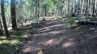
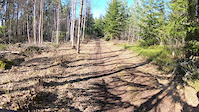
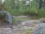
Photos of Gustafs Mountain Bike
trail: Lövtäktsvägen
88 |
May 19, 2020 @ 2:38pm
May 19, 2020
trail: Lövtäktsvägen
98 |
Jan 18, 2020 @ 2:01pm
Jan 18, 2020Videos of Gustafs Mountain Bike
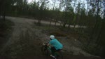
trail: Acktjärn Norr Sommar
2:58 |
48 |
Apr 7, 2020
trail: Acktjärn Norr Sommar
1:49 |
20 |
Apr 7, 2020
trail: Gropen
2:13 |
738 |
Jul 27, 2010
trail: Stenigt
0:31 |
538 |
Jun 21, 2008
Recent Trail Reports
| status | trail | date | condition | info | user |
|---|---|---|---|---|---|
| Skoterleden | Jul 26, 2023 @ 4:40am Jul 26, 2023 | Wet | xcilez | ||
| Stök Och Bök | Jul 26, 2023 @ 4:09am Jul 26, 2023 | Wet | xcilez | ||
| Skoterled Elledning | Jul 17, 2022 @ 3:35am Jul 17, 2022 | Variable | xcilez | ||
| Enduro 2 | Jul 17, 2022 @ 3:18am Jul 17, 2022 | Ideal | xcilez | ||
| Rönnmyra Ravin | Jul 17, 2022 @ 2:53am Jul 17, 2022 | Ideal | xcilez | ||
| Liststigen | Aug 3, 2021 @ 4:28am Aug 3, 2021 | Dry | Granitapan | ||
| Insticket | Aug 3, 2021 @ 4:28am Aug 3, 2021 | Dry | Granitapan | ||
| Riskan | Aug 3, 2021 @ 4:28am Aug 3, 2021 | Dry | Granitapan | ||
| Bumpastigen | Aug 3, 2021 @ 4:28am Aug 3, 2021 | Dry | Granitapan | ||
| Milspåret 4 | Aug 3, 2021 @ 4:28am Aug 3, 2021 | Dry | Granitapan |
Activity Feed
| username | action | type | title | date |
|---|---|---|---|---|
| OrjanX | update | trail | activity #42256831 | Jul 27, 2023 @ 7:56am Jul 27, 2023 |
| xcilez | add | report | activity #42211262 and 1 more | Jul 26, 2023 @ 4:09am Jul 26, 2023 |
| xcilez | vote | trail | activity #42211175 and 1 more | Jul 26, 2023 @ 4:06am Jul 26, 2023 |
| Mrdo | wishlist | route | activity #41215855 | Jun 24, 2023 @ 2:55am Jun 24, 2023 |
| niclasfohlin | wishlist | region | activity #41051178 | Jun 18, 2023 @ 11:13am Jun 18, 2023 |
Nearby Areas
| name | distance | ||||
|---|---|---|---|---|---|
| Romme | 36 | 23 | 4.4 km | ||
| Rösåsen | 34 | 37 | 5 km | ||
| Säter | 97 | 49 | 5.7 km | ||
| Uvberget | 6 | 15 | 6.7 km | ||
| Flatåsen | 6 | 13 | 7.2 km |
Local Badges
-

Completionist0 awarded
Activity Type Stats
| activitytype | trails | distance | descent | descent distance | total vertical | rating | global rank | state rank | photos | reports | routes | ridelogs |
|---|---|---|---|---|---|---|---|---|---|---|---|---|
| Mountain Bike | 375 | 173 miles | 10,223 ft | 67 miles | 820 ft | #6,122 | #208 | 2 | 32 | 2 | 1,054 | |
| Horse | 6 | 1 mile | 30 ft | 1,066 ft | 213 ft | #89 | 1 | |||||
| Hike | 374 | 172 miles | 10,125 ft | 66 miles | 820 ft | #5,173 | #168 | 32 | 9 | |||
| Trail Running | 374 | 172 miles | 10,125 ft | 66 miles | 820 ft | #5,193 | #170 | 32 | 1 | 47 | ||
| Backcountry Ski | 16 | 7 miles | 466 ft | 3 miles | 213 ft | #120 | #6 | |||||
| Nordic Ski | 12 | 6 miles | 440 ft | 3 miles | 190 ft | 2 |
- By Cykelsadel
 & contributors
 - Admins: svenakela, Tote, MagnusThornberg, Cykelsadel
- #29605 - 2,581 views
- gustafs activity log | embed map of Gustafs mountain bike trails | gustafs mountain biking points of interest
Downloading of trail gps tracks in kml & gpx formats is enabled for Gustafs.
You must login to download files.