close
-
Layers w
- Weather Layers
- Pro
- Pro
- Pro
- Pro
- Pro
- Pro
- More Layers
- Pro
- Pro
- Pro
- Pro
-
Upgrade to

3D
Trail Conditions
- Unknown
- Snow Groomed
- Snow Packed
- Snow Covered
- Snow Cover Partial
- Freeze/thaw Cycle
- Icy
- Prevalent Mud
- Wet
- Variable
- Ideal
- Dry
- Very Dry
Trail Flow (Ridden Direction)
Trailforks scans users ridelogs to determine the most popular direction each trail is ridden. A good flowing trail network will have most trails flowing in a single direction according to their intension.
The colour categories are based on what percentage of riders are riding a trail in its intended direction.
The colour categories are based on what percentage of riders are riding a trail in its intended direction.
- > 96%
- > 90%
- > 80%
- > 70%
- > 50%
- < 50%
- bi-directional trail
- no data
Trail Last Ridden
Trailforks scans ridelogs to determine the last time a trail was ridden.
- < 2 days
- < 1 week
- < 2 weeks
- < 1 month
- < 6 months
- > 6 months
Trail Ridden Direction
The intended direction a trail should be ridden.
- Downhill Only
- Downhill Primary
- Both Directions
- Uphill Primary
- Uphill Only
- One Direction
Contribute Details
Colors indicate trail is missing specified detail.
- Description
- Photos
- Description & Photos
- Videos
Trail Popularity ?
Trailforks scans ridelogs to determine which trails are ridden the most in the last 9 months.
Trails are compared with nearby trails in the same city region with a possible 25 colour shades.
Think of this as a heatmap, more rides = more kinetic energy = warmer colors.
- most popular
- popular
- less popular
- not popular
ATV/ORV/OHV Filter
Max Vehicle Width
inches
US Cell Coverage
Legend

Radar Time
Activity Recordings
Trailforks uses anonymized public activity data.
?
Activity Recordings
Trailforks uses anonymized public activity data.
?
Personal Heatmap
▶
Activity Types
all
/
none
▶
Options
2
Date range
month
–
Winter Trails
Warning
A routing network for winter maps does not exist. Selecting trails using the winter trails layer has been disabled.
Missing Trails
Most Popular
Least Popular
Trails are colored based on popularity. The more popular a trail is, the more red. Less popular trails trend towards green.
Jump Magnitude Heatmap
Heatmap of where riders jump on trails. Zoom in to see individual jumps, click circles to view jump details.
BC Backroad Status
![map legend]()
Service Road Atlas is a free to use, community-driven service for viewing and creating reports on the numerous back-country service roads around B.C. and Alberta.

Slope Aspect
Direction the slope faces
Trails Deemphasized
Trails are shown in grey.
Only show trails with no bike usage.
Suggested Layers
Based on selected activity type
Save the current map location and zoom level as your default home location whenever this page is loaded.
Save
No description for Kassel has been added yet!
Login or register to submit one.
This region uses the Uk/Euro style trail grading system.
Activities Click to view
- Mountain Bike
23 trails
- E-Bike
23 trails
- Adaptive Bike
0 trails
- Winter Fat Bike
0 trails
- Hike
11 trails
- Trail Running
11 trails
Region Details
- 9
- 11
- 3
Region Status
Caution as of Sep 18, 2025Stats
- Avg Trail Rating
- Trails (view details)
- 23
- Trails Mountain Bike
- 23
- Trails E-Bike
- 23
- Trails Hike
- 11
- Trails Trail Running
- 11
- Total Distance
- 11 miles
- Total Descent
- 5,806 ft
- Total Vertical
- 1,196 ft
- Highest Trailhead
- 2,061 ft
- Reports
- 26
- Photos
- 14
- Ridden Counter
- 539
Sub Regions
-
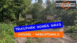
TrailPark Hohes Gras
- 4
- 2
- 1
Popular Kassel Mountain Biking Trails
• 100 ★ 0.0 • 2,205 ft • 0 ft • 48 •
Start: Bergstation Streckenlänge: 0,9 km max. Schwierigkeit: sehr leicht (grün) Dieser Trail endet am unteren Kreuzungsbereich „Mittelstation“. Hier befindet sich der Einstieg zu vier weiteren Trails.
• 95 ★ 0.0 • 837 ft • 0 ft • 43 •
Start: Mittelstation Streckenlänge: 0,3 km max. Schwierigkeit: mittelschwer (orange) Hinweis: Dieser Trail mündet auf den Flowtrail und führt weiter Richtung Ziegenkopf. Um zum Parkplatz Roter Stollen, der Bergstation am Hohen Gras...
• 100 ★ 0.0 • 932 ft • 2 ft • 40 •
Start: Mittelstation Streckenlänge: 0,4 km max. Schwierigkeit: mittelschwer (orange) Auf der Jumpline erwarten Dich diverse Tables und Sprungelemente, die aber auch alle überrollt werden können. Dieser Trail mündet auf der und...
• 80 ★ 0.0 • 2,651 ft • 0 ft • 38 •
Start: Mittelstation Streckenlänge: 0,9 km max. Schwierigkeit: sehr leicht (grün) Hinweis: Dieser Trail führt Richtung Ziegenkopf. Um zum Parkplatz Roter Stollen, der Bergstation am Hohen Gras oder zur Mittelstation zurückzukehren,...
• 90 ★ 0.0 • 1,837 ft • 18 ft • 36 •
Start: Mittelstation Streckenlänge: 0,6 km max. Schwierigkeit: sehr leicht (grün) Dieser Trail führt über die Rinderweide zur Talstation des Liftes. Von hier aus gelangst Du mit dem Lift (abhängig von dessen Öffnung) zur...
• 85 ★ 0.0 • 1,886 ft • 0 ft • 27 •
Start: Bergstation Streckenlänge: 0,6 km max. Schwierigkeit: leicht (gelb) Dieser Trail mündet auf den Flowtrail „ “. Nach ca. 200 m erreichst Du den unteren Kreuzungsbereich „Mittelstation“. Hier befindet sich der Einstieg zu...
• 55 ★ 0.0 • 1 mile • 2 ft • 20 •
Moderately popular blue difficulty singletrack. This multi-use trail can be used downhill primary. On average it takes 8 minutes to complete this trail.
• 65 ★ 5.0 • 2,251 ft • 0 ft • 18 •
Moderately popular blue difficulty singletrack. This mountain bike primary trail can be used downhill primary. It features jump, gap jump and rock garden. On average it takes 3 minutes to complete this trail.
Kassel Mountain Bike Routes
10 miles • 1,165 ft • 0 • Loop •
Von zwei Startpunkten aus kann man die ca. 16 km lange Strecke beginnen. Die Strecke führt teilweise...
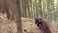
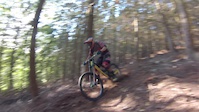
Photos of Kassel Mountain Bike
Videos of Kassel Mountain Bike

trail: Speed
6:03 |
143 |
Apr 25, 2017
trail: Speed
2:19 |
858 |
May 4, 2016
trail: Speed
0:19 |
293 |
Aug 25, 2015

trail: Speed
0:15 |
59 |
Jul 30, 2015

trail: Hawk-Line
9:53 |
97 |
Nov 5, 2024 , Kassel

trail: Goathead-Trail
9:53 |
77 |
Nov 5, 2024 , Kassel

trail: Forest-Jump
9:53 |
93 |
Nov 5, 2024 , Kassel
youtuber
![EMTB - Bikepark Habichtswald bei Kassel -...]()
trail: Racoon-Line
9:53 |
89 |
Nov 5, 2024 , Kassel
Recent Trail Reports
| status | trail | date | condition | info | user |
|---|---|---|---|---|---|
| Bröffel-Trail | Sep 18, 2025 @ 4:29pm (Europe/Berlin) Sep 18, 2025 | Unknown | jackesses | ||
| Racoon-Line | Jul 12, 2025 @ 4:19pm Jul 12, 2025 | Ideal | alexschrodt | ||
| Hawk-Line | Jul 12, 2025 @ 4:19pm Jul 12, 2025 | Ideal | alexschrodt | ||
| Raven-Trail | Jul 12, 2025 @ 4:19pm Jul 12, 2025 | Ideal | alexschrodt | ||
| DH Speed Line | Aug 12, 2023 @ 6:55am Aug 12, 2023 | Variable | Mattes79 | ||
| Elfbuchen Speed DH | May 29, 2023 @ 5:28am May 29, 2023 | Dry | Wilja | ||
| Schweiz | Dec 10, 2022 @ 9:06pm Dec 10, 2022 | Snow Groomed | DonPromilloKS | ||
| Herkules -> Asch | Dec 11, 2022 @ 5:06am Dec 11, 2022 | Snow Packed | DonPromilloKS | ||
| Hohes Gras DH | Jun 13, 2022 @ 4:41am Jun 13, 2022 | Dry | DonPromilloKS | ||
| Ahne-Trail | Oct 8, 2021 @ 4:15pm Oct 8, 2021 | Wet | alexschrodt |
Activity Feed
| username | action | type | title | date |
|---|---|---|---|---|
| c3ZnQN | wishlist | trail | activity #92205614 | Apr 8, 2026 @ 12:54pm Apr 8, 2026 |
| DvCt9qr | add | trail | activity #91187682 | Mar 24, 2026 @ 12:27am Mar 24, 2026 |
| DvCt9qr | vote | trail | activity #91008001 | Mar 21, 2026 @ 11:13am Mar 21, 2026 |
| DvCt9qr | ridden | trail | activity #91007129 | Mar 21, 2026 @ 11:04am Mar 21, 2026 |
| DvCt9qr | ridden | trail | activity #90176469 | Mar 8, 2026 @ 12:53am Mar 8, 2026 |
Recent Comments
| username | type | title | comment | date |
|---|---|---|---|---|
| trail | Sehr schöner Trail. Gut mecht, ein paar... | Aug 23, 2023 @ 9:27am Aug 23, 2023 | ||
| trail | Gerade sehr zugewachsen und in der Mitte... | Aug 23, 2023 @ 5:32am Aug 23, 2023 | ||
| trail | Einstieg komplett überwachsen | Oct 10, 2022 @ 4:08am Oct 10, 2022 | ||
| trail | Einstieg komplett überwachsen | Oct 10, 2022 @ 4:07am Oct 10, 2022 | ||
| trail | Neuer Sturmschaden: Baum liegt im mittlerem... | May 17, 2022 @ 9:03am May 17, 2022 |
Local Badges
-

Epic Mountain Bike Climb 2k9 awarded -

Climbing 10k Badge8 awarded -

Mountain Biking 100k Badge0 awarded -

Epic Ride Descent 2k9 awarded -

Descent 10k Badge8 awarded -

Descent 100k Badge0 awarded
Activity Type Stats
| activitytype | trails | distance | descent | descent distance | total vertical | rating | global rank | state rank | photos | reports | routes | ridelogs |
|---|---|---|---|---|---|---|---|---|---|---|---|---|
| Mountain Bike | 23 | 11 miles | 5,807 ft | 10 miles | 1,198 ft | #5,084 | #113 | 13 | 26 | 1 | 4,078 | |
| E-Bike | 23 | 11 miles | 5,807 ft | 10 miles | 1,198 ft | #4,316 | #123 | 1 | 22 | 1 | 747 | |
| Hike | 11 | 6 miles | 3,360 ft | 6 miles | 1,198 ft | #7,971 | #138 | 24 | 83 | |||
| Trail Running | 11 | 6 miles | 3,360 ft | 6 miles | 1,198 ft | #7,434 | #132 | 24 | 28 |
Frequently Asked Questions About Kassel
▼
What are the best places to ride in Kassel?
Kassel has 1 areas to explore for mountain biking. The top rated areas are:
▼
What are the highest rated mountain biking trails in Kassel?
The highest rated mountain biking trails in Kassel are:
- DH Speed Line (4.1/5)
- Milan (4/5)
- Speed (4/5)
- Neu Holland Trail (4/5)
- Milky Way (Reifenkiller) (3.5/5)
▼
What is the best time of the year to ride in Kassel?
Based on ride log data, the most popular months to ride in Kassel are:
- July (26 activities)
- June (22 activities)
- October (20 activities)
▼
Where can I park to ride in Kassel?
Check the Kassel trail map for trailhead and parking information. Community members regularly update access and parking details for trails in the area.
Activities
Trails
Points of Interest
- By nilsdoenduro & contributors
- Admins: HDRiders, sp00n82
- #28718 - 5,756 views
- kassel activity log | embed map of Kassel mountain bike trails |
Downloading of trail gps tracks in kml & gpx formats is enabled for Kassel.
You must login to download files.