close
-
Layers w
- Weather Layers
- Pro
- Pro
- Pro
- Pro
- Pro
- Pro
- More Layers
- Pro
- Pro
- Pro
- Pro
-
Upgrade to

3D
Trail Conditions
- Unknown
- Snow Groomed
- Snow Packed
- Snow Covered
- Snow Cover Partial
- Freeze/thaw Cycle
- Icy
- Prevalent Mud
- Wet
- Variable
- Ideal
- Dry
- Very Dry
Trail Flow (Ridden Direction)
Trailforks scans users activity logs to determine the most popular direction each trail is ridden. A good flowing trail network will have most trails flowing in a single direction according to their intension.
The colour categories are based on what percentage of users are riding a trail in its intended direction.
The colour categories are based on what percentage of users are riding a trail in its intended direction.
- > 96%
- > 90%
- > 80%
- > 70%
- > 50%
- < 50%
- bi-directional trail
- no data
Trail Last Ridden
Trailforks scans activity logs to determine the last time a trail was ridden.
- < 2 days
- < 1 week
- < 2 weeks
- < 1 month
- < 6 months
- > 6 months
Trail Ridden Direction
The intended direction a trail should be ridden.
- Downhill Only
- Downhill Primary
- Both Directions
- Uphill Primary
- Uphill Only
- One Direction
Contribute Details
Colors indicate trail is missing specified detail.
- Description
- Photos
- Description & Photos
- Videos
Trail Popularity ?
Trailforks scans activity logs to determine which trails are ridden the most in the last 9 months.
Trails are compared with nearby trails in the same city region with a possible 25 colour shades.
Think of this as a heatmap, more activities = more kinetic energy = warmer colors.
- most popular
- popular
- less popular
- not popular
ATV/ORV/OHV Filter
Max Vehicle Width
inches
US Cell Coverage
Legend

Radar Time
Activity Recordings
Trailforks uses anonymized public activity data.
?
Activity Recordings
Trailforks uses anonymized public activity data.
?
Personal Heatmap
▶
Activity Types
all
/
none
▶
Options
2
Date range
month
–
Winter Trails
Warning
A routing network for winter maps does not exist. Selecting trails using the winter trails layer has been disabled.
Missing Trails
Most Popular
Least Popular
Trails are colored based on popularity. The more popular a trail is, the more red. Less popular trails trend towards green.
Jump Magnitude Heatmap
Heatmap of where users jump on trails. Zoom in to see individual jumps, click circles to view jump details.
BC Backroad Status
![map legend]()
Service Road Atlas is a free to use, community-driven service for viewing and creating reports on the numerous back-country service roads around B.C. and Alberta.

Slope Aspect
Direction the slope faces
Trails Deemphasized
Trails are shown in grey.
Only show trails with no bike usage.
Suggested Layers
Based on selected activity type
Save the current map location and zoom level as your default home location whenever this page is loaded.
SavePopular Trail Networks
view all areas »
No description for Kenya has been added yet!
Login or register to submit one.
Region Details
- 187
- 7
- 144
- 133
- 48
- 2
Stats
- Avg Trail Rating
- Trails (view details)
- 523
- Trails Mountain Bike
- 553
- Trails E-Bike
- 546
- Trails Horse
- 25
- Trails Hike
- 556
- Trails Trail Running
- 550
- Trails Dirtbike/Moto
- 5
- Total Distance
- 825 miles
- Total Descent
- 137,687 ft
- Total Vertical
- 16,169 ft
- Highest Trailhead
- 16,189 ft
- Reports
- 246
- Photos
- 295
- Completed Counter
- 3,566
Articles
Video: Rob Warner & Matt Jones Tackle Mount Kenya
Nov 13, 2019 from pinkbike.com
Dodging wildlife and meeting the locals in east Africa
Sub Regions
- Baringo County (3)
- Kabarnet (3)
- Elgeyo Marakwet County (23)
- Iten (23)
- Cherengani Hills (6)
- Iten Trails (17)
- Iten (23)
- Kajiado County (0)
- Kiambu County (109)
- Kijabe (105)
- Kijabe Trails (102)
- Kimende (4)
- Kijabe (105)
- Kilifi County (182)
- Kilifi (177)
- Mwangea (8)
- Vipingo Trails (169)
- Watamu (2)
- Kilifi (177)
- Laikipia County (2)
- Nanyuki (2)
- Borana Trails (2)
- Nanyuki (2)
- Machakos County (0)
- Makueni County (19)
- Wote (19)
- Ulu Conservancy (19)
- Wote (19)
- Migori County (0)
- Mombasa County (3)
- Mombasa (3)
- Haller Park (0)
- Nguuni Trails (3)
- Mombasa (3)
- Murang'a County (17)
- Sagana (17)
- Sagana Trails (17)
- Sagana (17)
- Nairobi County (92)
- Nairobi (92)
- Karura Forest (74)
- Ngong Hills (16)
- Ngong Road Forest (1)
- Two Rivers Sports District (1)
- Nairobi (92)
- Nakuru County (1)
- Gilgil (1)
- Nakuru (1)
- Londiani Trails (1)
- Gilgil (1)
- Narok County (0)
- Nyandarua County (0)
- Nyeri County (5)
- Karatina (1)
- Karatina Trails (1)
- Nyeri (5)
- Aberdares (2)
- Karatina (1)
- Taita Taveta County (106)
- Wundanyi (106)
- Taita Hills (92)
- Wundanyi (106)
Popular Kenya Mountain Biking Trails
• 95 ★ 0.0 • 902 ft • 23 ft • 33 •
Popular blue difficulty singletrack. This multi-use trail can be used both directions and has a moderate overall physical rating with a 23 ft blue climb. Trail visibility is always easy to follow. On average it takes 1 minutes to complete this trail.
• 90 ★ 0.0 • 4,003 ft • 49 ft • 30 •
Popular green difficulty singletrack. This multi-use trail can be used both directions and has a easy overall physical rating with a 49 ft green climb. Trail visibility is always easy to follow. On average it takes 3 minutes to complete this trail.
• 95 ★ 5.0 • 1,608 ft • 0 ft • 28 •
Fun, flowy downhill through the beautiful Kijabe forest reserve.
• 100 ★ 4.7 • 4,173 ft • 0 ft • 28 •
Wild forest, some features being added continually.
• 65 ★ 0.0 • 2 miles • 77 ft • 27 •
is a good start trail at the main Karura location. Some rocky obstacles. Trail ends at a fence, take any of the off-shoots heading to the left (North). Don't turn right.
• 100 ★ 4.5 • 1,736 ft • 0 ft • 26 •
Popular blue difficulty singletrack. This mountain bike primary trail can be used downhill primary. On average it takes 3 minutes to complete this trail.
• 65 ★ 0.0 • 728 ft • 0 ft • 24 •
Moderately popular green difficulty singletrack. This multi-use trail can be used both directions and has a easy overall physical rating with a 0 ft green climb. Trail visibility is always easy to follow. On average it takes minutes to complete this trail.
• 70 ★ 0.0 • 2,402 ft • 29 ft • 23 •
Popular blue difficulty singletrack. This multi-use trail can be used both directions and has a moderate overall physical rating with a 29 ft green climb. Trail visibility is always easy to follow. On average it takes 2 minutes to complete this trail.
Kenya Mountain Bike Routes
★ 5.0 • 5 miles • 61 ft • 5 • Shuttled •
The superb and finishing off with . can be skipped by taking the tarmac road down to the shuttle.
★ 5.0 • 7 miles • 222 ft • 3 • Shuttled •
Two great trails down the hill from Wundanyi to Mwatate, with a bonus little trail at the start. can be...
★ 5.0 • 4 miles • 262 ft • 6 • Shuttled •
Probably the best combo on this part of the hill starting with the excellent Stone Mine. Arrange your...
★ 5.0 • 5 miles • 324 ft • 3 • Loop •
A beautiful scenic route around the Chodari dam in the Vipingo Ridge wildlife sanctuary. A few medium...
★ 5.0 • 3 miles • 141 ft • 1 • Loop •
A route around the eucalyptus forest with views over the motocross track, an area often favoured by the...
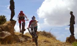
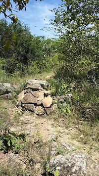
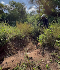
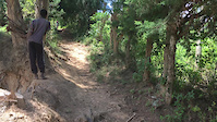
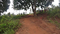
Photos of Kenya Mountain Bike
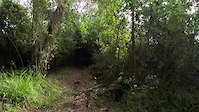
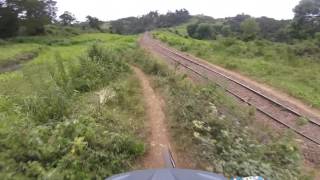
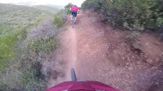
Videos of Kenya Mountain Bike
trail: Rock Lobster
0:26 |
13 |
May 6, 2025
trail: Toby's
0:07 |
30 |
Jun 18, 2024
trail: Midnight Train
0:24 |
28 |
Oct 28, 2023
trail: Wundanyi Ridge
0:07 |
71 |
May 24, 2021
trail: Down Dog
0:06 |
93 |
Aug 12, 2020

trail: Under The "S" / Adamsbridge
3:24 |
302 |
Dec 13, 2021 , Kijabe
trail: Brickyard
4:41 |
543 |
Dec 13, 2021 , Kijabe
trail: Dead Drop
4:56 |
337 |
Dec 13, 2021 , Kijabe
Recent Comments
| username | type | title | comment | date |
|---|---|---|---|---|
| trail | Completely overgrown and washed away I even... | May 24, 2026 @ 1:11am May 24, 2026 | ||
| trail | Out of order right now, not passable | Apr 5, 2026 @ 11:44am Apr 5, 2026 | ||
| trail | Thanks for adding this! Yes, it’s super hard... | Mar 31, 2026 @ 11:15am Mar 31, 2026 | ||
| trail | Nice hiking trail | May 31, 2025 @ 9:36am May 31, 2025 | ||
| trail | Lots of walking | May 31, 2025 @ 9:35am May 31, 2025 |
Bike & Skill Parks
| name | type | city | rating |
|---|---|---|---|
| Twiga Place | skill park | Nairobi |
Activity Type Stats
| activitytype | trails | distance | descent | descent distance | total vertical | rating | global rank | state rank | photos | reports | routes | activity logs |
|---|---|---|---|---|---|---|---|---|---|---|---|---|
| Mountain Bike | 548 | 823 miles | 136,063 ft | 395 miles | 16,168 ft | #43 | 290 | 246 | 67 | 15,565 | ||
| E-Bike | 546 | 808 miles | 131,562 ft | 388 miles | 16,168 ft | #38 | 236 | 43 | 160 | |||
| Horse | 25 | 24 miles | 4,882 ft | 14 miles | 8,474 ft | #57 | 21 | |||||
| Hike | 555 | 819 miles | 135,679 ft | 394 miles | 16,168 ft | #42 | 1 | 242 | 16 | 2,716 | ||
| Trail Running | 549 | 789 miles | 132,297 ft | 383 miles | 16,168 ft | #41 | 9 | 242 | 18 | 706 | ||
| Dirtbike/Moto | 5 | 5 miles | 351 ft | 2 miles | 8,100 ft | #65 | 21 | 3 |
Activities
Trails
- By canadaka
 Trailforks & contributors
 - Admins: Kenya
- #15001 - 16,767 views
- kenya activity log | embed map of Kenya mountain bike trails | kenya mountain biking points of interest
Downloading of trail gps tracks in kml & gpx formats is enabled for Kenya.
You must login to download files.