close
-
Layers w
- Weather Layers
- Pro
- Pro
- Pro
- Pro
- Pro
- Pro
- More Layers
- Pro
- Pro
- Pro
- Pro
-
Upgrade to

3D
Trail Conditions
- Unknown
- Snow Groomed
- Snow Packed
- Snow Covered
- Snow Cover Partial
- Freeze/thaw Cycle
- Icy
- Prevalent Mud
- Wet
- Variable
- Ideal
- Dry
- Very Dry
Trail Flow (Ridden Direction)
Trailforks scans users ridelogs to determine the most popular direction each trail is ridden. A good flowing trail network will have most trails flowing in a single direction according to their intension.
The colour categories are based on what percentage of riders are riding a trail in its intended direction.
The colour categories are based on what percentage of riders are riding a trail in its intended direction.
- > 96%
- > 90%
- > 80%
- > 70%
- > 50%
- < 50%
- bi-directional trail
- no data
Trail Last Ridden
Trailforks scans ridelogs to determine the last time a trail was ridden.
- < 2 days
- < 1 week
- < 2 weeks
- < 1 month
- < 6 months
- > 6 months
Trail Ridden Direction
The intended direction a trail should be ridden.
- Downhill Only
- Downhill Primary
- Both Directions
- Uphill Primary
- Uphill Only
- One Direction
Contribute Details
Colors indicate trail is missing specified detail.
- Description
- Photos
- Description & Photos
- Videos
Trail Popularity ?
Trailforks scans ridelogs to determine which trails are ridden the most in the last 9 months.
Trails are compared with nearby trails in the same city region with a possible 25 colour shades.
Think of this as a heatmap, more rides = more kinetic energy = warmer colors.
- most popular
- popular
- less popular
- not popular
ATV/ORV/OHV Filter
Max Vehicle Width
inches
US Cell Coverage
Legend

Radar Time
Activity Recordings
Trailforks uses anonymized public activity data.
?
Activity Recordings
Trailforks uses anonymized public activity data.
?
Personal Heatmap
▶
Activity Types
all
/
none
▶
Options
2
Date range
month
–
Winter Trails
Warning
A routing network for winter maps does not exist. Selecting trails using the winter trails layer has been disabled.
Missing Trails
Most Popular
Least Popular
Trails are colored based on popularity. The more popular a trail is, the more red. Less popular trails trend towards green.
Jump Magnitude Heatmap
Heatmap of where riders jump on trails. Zoom in to see individual jumps, click circles to view jump details.
BC Backroad Status
![map legend]()
Service Road Atlas is a free to use, community-driven service for viewing and creating reports on the numerous back-country service roads around B.C. and Alberta.

Slope Aspect
Direction the slope faces
Trails Deemphasized
Trails are shown in grey.
Only show trails with no bike usage.
Suggested Layers
Based on selected activity type
Save the current map location and zoom level as your default home location whenever this page is loaded.
Save
No description for Leadville has been added yet!
Login or register to submit one.
Activities Click to view
- Mountain Bike
113 trails
- E-Bike
41 trails
- Gravel Bike
7 trails
- Adaptive Bike
0 trails
- Winter Fat Bike
0 trails
- Horse
100 trails
- Hike
202 trails
- Trail Running
203 trails
- Dirtbike/Moto
10 trails
- ATV/ORV/OHV
5 trails
- Snowshoe
14 trails
- Downhill Ski
63 trails
- Backcountry Ski
20 trails
- Nordic Ski
29 trails
Region Details
- 25
- 1
- 23
- 47
- 16
Region Status
Caution as of May 31, 2026Local Trail Association
Stats
- Avg Trail Rating
- Trails (view details)
- 267
- Trails Mountain Bike
- 113
- Trails E-Bike
- 41
- Trails Gravel Bike
- 7
- Trails Horse
- 100
- Trails Hike
- 203
- Trails Trail Running
- 203
- Trails Dirtbike/Moto
- 10
- Trails ATV/ORV/OHV
- 5
- Trails Snowmobile
- 3
- Trails Snowshoe
- 14
- Trails Downhill Ski
- 63
- Trails Backcountry Ski
- 20
- Trails Nordic Ski
- 29
- Total Distance
- 509 miles
- Total Descent
- 91,237 ft
- Total Vertical
- 5,680 ft
- Highest Trailhead
- 14,420 ft
- Reports
- 1,681
- Photos
- 280
- Ridden Counter
- 25,494
Sub Regions
-
Collegiate Peaks Wilderness
- 2
- 3
-
Evergreen Lakes Nature Trails
-
PNF - Leadville Ranger District
- 1
-
Ski Cooper
- 1
-
Timberline Trails
- 12
- 13
- 2
-
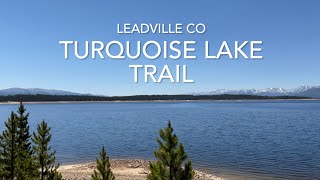
Turquoise Lake Trails
- 2
-
Twin Lakes
- 1
- 2
- 12
- 10
Popular Leadville Mountain Biking Trails
• 100 ★ 0.0 • 1 mile • 2 ft • 876 •
Easy singletrack trail that is used as part of the Leadville 100
• 100 ★ 4.0 • 1,657 ft • 16 ft • 458 •
Popular blue difficulty singletrack. This mountain bike primary trail can be used both directions. On average it takes 2 minutes to complete this trail.
• 95 ★ 3.4 • 3,199 ft • 89 ft • 447 •
Nice climbing trail to get you up to the trails that are fun to flow down
• 95 ★ 4.2 • 1 mile • 40 ft • 438 •
Ride the rollers through the trees. Recommended to enjoy in the clockwise direction.
• 95 ★ 4.0 • 3,875 ft • 22 ft • 431 •
Speed through the trees on this mellow stretch of single track. Great route for kids and beginners.
• 100 ★ 4.0 • 666 ft • 0 ft • 395 •
Popular blue difficulty singletrack. This mountain bike primary trail can be used both directions. On average it takes minutes to complete this trail.
• 80 ★ 3.8 • 1 mile • 57 ft • 387 •
Popular blue difficulty singletrack. This multi-use trail can be used both directions and has a moderate overall physical rating with a 57 ft blue climb. On average it takes 10 minutes to complete this trail.
• 90 ★ 4.4 • 1 mile • 20 ft • 366 •
Great flowy trail that takes you winding through the aspen trees. The trail is ridden almost exclusively down from the top of .
Leadville Mountain Bike Routes
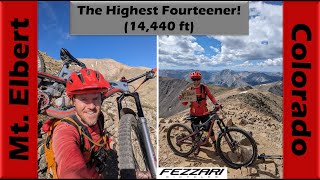
Mt. Elbert - Shuttle Featured
★ 5.0 • 17 miles • 5,086 ft • 5 • Shuttled •
Who doesn't want to ride off the highest peak in the Rocky Mountains! This route takes a shuttle approach...
9 miles • 152 ft • 2 •
A ride from Tennessee Pass down to Camp Hale. Be sure to ride in control and know that you will see plenty...
16 miles • 1,359 ft • 4 •
This is a 16 mile loop around the largest glacial lakes in Colorado. This ride includes the Twin Lakes Cut...
8 miles • 667 ft • 8 •
Annual Pedal for the Park Fundraiser Adult Lap
17 miles • 1,134 ft • 9 •
Route- Dutch Henry around the to Boulders-Elk Run-Upper Deck-Wheelers Way- Golddigger-Cold Feet-Wheelers...
4 miles • 243 ft • 2 • Out & Back •
This short out-and-back on Colorado Trail segment 11 travels along Twin Lakes to the historic Inter-Laken...
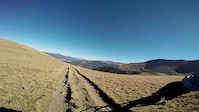
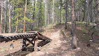
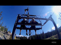
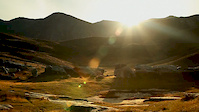
Photos of Leadville Mountain Bike
Videos of Leadville Mountain Bike

trail: Mount Elbert
0:00 |
74 |
Jul 12, 2021
trail: CDT CT - Twin Lakes North
3:28 |
108 |
Jan 29, 2017
trail: Boonedoggle
0:13 |
233 |
Apr 23, 2016
trail: Mt. Elbert Cutoff
3:18 |
694 |
Sep 18, 2012
trail: Mt. Elbert Cutoff
6:05 |
15042 |
Apr 16, 2012
trail: Turquoise Lake
8:24 |
281 |
May 22, 2024 , Leadville
youtuber
![Mt. Elbert - Epic Mountain Biking on...]()
trail: South Mount Elbert
36:05 |
307 |
Sep 5, 2023 , Leadville

trail: CDT CT - Twin Lakes South
0:17 |
239 |
Aug 29, 2023 , Leadville
Recent Trail Reports
| status | trail | date | condition | info | user |
|---|---|---|---|---|---|
| CT Lodgepole Connector | May 31, 2026 @ 10:09am (America/Denver) May 31, 2026 | Ideal | leadvegas CCW | ||
| Pakkas | May 19, 2026 @ 5:54pm (America/Denver) May 19, 2026 | Dry | leadvegas CCW | ||
| Old Chub | May 19, 2026 @ 5:54pm (America/Denver) May 19, 2026 | Dry | leadvegas CCW | ||
| Cold Feet | May 19, 2026 @ 5:54pm (America/Denver) May 19, 2026 | Dry | leadvegas CCW | ||
| Golddigger | May 19, 2026 @ 5:54pm (America/Denver) May 19, 2026 | Dry | leadvegas CCW | ||
| Wedgie | May 19, 2026 @ 5:54pm (America/Denver) May 19, 2026 | Dry | leadvegas CCW | ||
| Elk Run (Connect) | May 19, 2026 @ 5:54pm (America/Denver) May 19, 2026 | Dry | leadvegas CCW | ||
| And Again | May 19, 2026 @ 5:54pm (America/Denver) May 19, 2026 | Dry | leadvegas CCW | ||
| Colorado Trail Connector | May 11, 2026 @ 6:39pm (America/Los_Angeles) May 11, 2026 | Ideal | leadvegas CCW | ||
| CT Connector | May 11, 2026 @ 6:39pm (America/Los_Angeles) May 11, 2026 | Ideal | leadvegas CCW |
National Scenic Trails & Official Routes
-
Colorado Trail (Bike)
- Mountain Bike
-
Continental Divide Trail
- Mountain Bike
- Hike
- Trail Running

Activity Feed
| username | action | type | title | date |
|---|---|---|---|---|
| Docstar88 | rsvp | event | activity #96373151 and 1 more | Jun 6, 2026 @ 8:20am 20 hours |
| dfritton | add | photo | activity #96338357 | Jun 5, 2026 @ 7:33pm 1 day |
| dfritton | add | photo | activity #96338349 | Jun 5, 2026 @ 7:33pm 1 day |
| RDangerous | add | photo | activity #96032133 and 2 more | Jun 1, 2026 @ 11:51am Jun 1, 2026 |
| leadvegas | add | report | activity #95966781 | May 31, 2026 @ 12:15pm May 31, 2026 |
Recent Comments
| username | type | title | comment | date |
|---|---|---|---|---|
| trail | Usually tons of trees down. Trail sees very... | Apr 3, 2026 @ 12:30pm Apr 3, 2026 | ||
| trail | Out and back from the Clear Creek side is one... | Apr 3, 2026 @ 12:30pm Apr 3, 2026 | ||
| trail | Out and back to the ridgeline is solid. Do... | Apr 3, 2026 @ 12:28pm Apr 3, 2026 | ||
| trail | Thanks for the stairs 14er Initiative | Apr 3, 2026 @ 12:26pm Apr 3, 2026 | ||
| trail | Another victim of trail sanitization Do not... | Apr 3, 2026 @ 12:25pm Apr 3, 2026 |
Local Badges
-

Completionist3 awarded -

Big Ride 30k3,311 awarded -

Epic Ride 50k1,946 awarded -

Top 10 Trails0 awarded -

Descent 100k Badge4 awarded -

10 Green Trails102 awarded
Bike & Skill Parks
| name | type | city | rating |
|---|---|---|---|
| Ski Cooper | bike park | Leadville | |
| Leadville Motocross Park | skill park | Leadville | |
| Lake County Bike Park | skill park | Leadville |
Upcoming Local Events
Activity Type Stats
| activitytype | trails | distance | descent | descent distance | total vertical | rating | global rank | state rank | photos | reports | routes | ridelogs |
|---|---|---|---|---|---|---|---|---|---|---|---|---|
| Mountain Bike | 113 | 263 miles | 30,876 ft | 104 miles | 5,597 ft | #632 | #236 | 242 | 1,655 | 35 | 17,300 | |
| E-Bike | 41 | 125 miles | 14,327 ft | 53 miles | 3,714 ft | #1,168 | #825 | 1 | 1,389 | 6 | 323 | |
| Gravel Bike | 7 | 21 miles | 3,094 ft | 10 miles | 2,762 ft | #323 | #949 | 1 | 343 | 1 | 41 | |
| Horse | 100 | 324 miles | 52,083 ft | 118 miles | 5,574 ft | #57 | #340 | 545 | 7 | 2 | ||
| Hike | 202 | 482 miles | 71,257 ft | 181 miles | 5,679 ft | #106 | #61 | 30 | 1,627 | 35 | 4,575 | |
| Trail Running | 203 | 476 miles | 69,551 ft | 176 miles | 5,679 ft | #190 | #85 | 7 | 1,629 | 36 | 1,133 | |
| Dirtbike/Moto | 10 | 41 miles | 5,154 ft | 12 miles | 3,278 ft | #603 | #205 | 1 | 774 | 7 | ||
| ATV/ORV/OHV | 5 | 27 miles | 3,058 ft | 7 miles | 3,278 ft | #495 | #169 | 773 | 2 | |||
| Snowmobile | 3 | 22 miles | 1,693 ft | 8 miles | 1,883 ft | 23 | 2 | 4 | ||||
| Snowshoe | 14 | 44 miles | 3,097 ft | 16 miles | 4,055 ft | #394 | #119 | 44 | 26 | 67 | ||
| Downhill Ski | 63 | 43 miles | 21,056 ft | 30 miles | 1,969 ft | #292 | #117 | 22 | 314 | |||
| Backcountry Ski | 20 | 26 miles | 4,478 ft | 12 miles | 2,152 ft | #342 | #65 | 35 | 3 | 969 | ||
| Nordic Ski | 29 | 49 miles | 4,183 ft | 21 miles | 1,004 ft | #377 | #99 | 43 | 8 | 626 |
Frequently Asked Questions About Leadville
▼
What are the best places to ride in Leadville?
Leadville has 9 areas to explore for mountain biking. The top rated areas are:
▼
What are the highest rated mountain biking trails in Leadville?
The highest rated mountain biking trails in Leadville are:
- Perma Grin (4.3/5)
- No Limits (4.2/5)
- Wheelers Way (4.2/5)
- Sheep Creek Trail (4.2/5)
- Elk Run (4.2/5)
▼
What is the best time of the year to ride in Leadville?
Based on ride log data, the most popular months to ride in Leadville are:
- July (247 activities)
- August (183 activities)
- June (137 activities)
▼
Where can I park to ride in Leadville?
There are 51 parking locations listed in Leadville. The most popular parking spots are: View all parking and trailhead locations on the map to plan your visit.
Activities
- Leadville Mountain Biking Trails
- Leadville E-Biking Trails
- Leadville Gravel Biking Trails
- Leadville Horseback Trails
- Leadville Hiking Trails
- Leadville Trail Running Trails
- Leadville Dirtbiking Trails
- Leadville ATVing/Offroading Trails
- Leadville Snowshoeing Trails
- Leadville Skiing Trails
- Leadville Backcountry Skiing Trails
- Leadville Nordic Skiing Trails
Trails
Points of Interest
- Betty Bear Hut Cabin
- Tennessee Pass Nordic Center Lodge
- Rivers End Campground Camping
- Chalk Lake Camp Camping
- Mount Oxford Summit
- Mount Belford Summit
- Huron Peak Summit
- Sangree Hut Cabin
- Interlaken Historic District Sight
- Mt. Elbert Summit
- Mount Elbert (14,423 ft)
- Mount Harvard (14,413 ft)
- La Plata Peak (14,337 ft)
- By canadaka
 Trailforks & contributors
 - Admins: CCW
- #4913 - 19,874 views
- leadville activity log | embed map of Leadville mountain bike trails | leadville mountain biking points of interest
Downloading of trail gps tracks in kml & gpx formats is enabled for Leadville.
You must login to download files.