close
-
Layers w
- Weather Layers
- Pro
- Pro
- Pro
- Pro
- Pro
- Pro
- More Layers
- Pro
- Pro
- Pro
- Pro
-
Upgrade to

3D
Trail Conditions
- Unknown
- Snow Groomed
- Snow Packed
- Snow Covered
- Snow Cover Partial
- Freeze/thaw Cycle
- Icy
- Prevalent Mud
- Wet
- Variable
- Ideal
- Dry
- Very Dry
Trail Flow (Ridden Direction)
Trailforks scans users ridelogs to determine the most popular direction each trail is ridden. A good flowing trail network will have most trails flowing in a single direction according to their intension.
The colour categories are based on what percentage of riders are riding a trail in its intended direction.
The colour categories are based on what percentage of riders are riding a trail in its intended direction.
- > 96%
- > 90%
- > 80%
- > 70%
- > 50%
- < 50%
- bi-directional trail
- no data
Trail Last Ridden
Trailforks scans ridelogs to determine the last time a trail was ridden.
- < 2 days
- < 1 week
- < 2 weeks
- < 1 month
- < 6 months
- > 6 months
Trail Ridden Direction
The intended direction a trail should be ridden.
- Downhill Only
- Downhill Primary
- Both Directions
- Uphill Primary
- Uphill Only
- One Direction
Contribute Details
Colors indicate trail is missing specified detail.
- Description
- Photos
- Description & Photos
- Videos
Trail Popularity ?
Trailforks scans ridelogs to determine which trails are ridden the most in the last 9 months.
Trails are compared with nearby trails in the same city region with a possible 25 colour shades.
Think of this as a heatmap, more rides = more kinetic energy = warmer colors.
- most popular
- popular
- less popular
- not popular
ATV/ORV/OHV Filter
Max Vehicle Width
inches
US Cell Coverage
Legend

Radar Time
Activity Recordings
Trailforks uses anonymized public activity data.
?
Activity Recordings
Trailforks uses anonymized public activity data.
?
Personal Heatmap
▶
Activity Types
all
/
none
▶
Options
2
Date range
month
–
Winter Trails
Warning
A routing network for winter maps does not exist. Selecting trails using the winter trails layer has been disabled.
Missing Trails
Most Popular
Least Popular
Trails are colored based on popularity. The more popular a trail is, the more red. Less popular trails trend towards green.
Jump Magnitude Heatmap
Heatmap of where riders jump on trails. Zoom in to see individual jumps, click circles to view jump details.
BC Backroad Status
![map legend]()
Service Road Atlas is a free to use, community-driven service for viewing and creating reports on the numerous back-country service roads around B.C. and Alberta.

Slope Aspect
Direction the slope faces
Trails Deemphasized
Trails are shown in grey.
Only show trails with no bike usage.
Suggested Layers
Based on selected activity type
Save the current map location and zoom level as your default home location whenever this page is loaded.
Save
No description for Leknes has been added yet!
Login or register to submit one.
This region uses the Uk/Euro style trail grading system.
Activities Click to view
- Mountain Bike
36 trails
- Hike
33 trails
- Trail Running
31 trails
Region Details
- 12
- 19
- 2
- 1
Region Status
Caution as of Jun 24, 2026Stats
- Avg Trail Rating
- Trails (view details)
- 36
- Trails Mountain Bike
- 36
- Trails E-Bike
- 11
- Trails Adaptive Bike
- 1
- Trails Hike
- 33
- Trails Trail Running
- 31
- Trails Snowshoe
- 12
- Trails Nordic Ski
- 11
- Total Distance
- 36 miles
- Total Descent
- 13,856 ft
- Total Vertical
- 2,275 ft
- Highest Trailhead
- 2,299 ft
- Reports
- 31
- Photos
- 24
- Ridden Counter
- 491
Sub Regions
-
Borgatoppen
- 4
Popular Leknes Mountain Biking Trails
• 55 ★ 3.7 • 2 miles • 183 ft • 91 •
Great trail along a ridge with an fantastic view.
• 5 ★ 3.4 • 3 miles • 284 ft • 35 •
A lovely trail to the summit of . Shown here as a descent for MTB purposes, just reverse the trail to hike or push your bike up. A challenging trail towards the top for both hikers and bikers, whether going up or coming down....
• 95 ★ 3.7 • 1 mile • 49 ft • 34 •
An alternative descent down off Smørdalskammen. Some really nice singletrack, a couple of sections that are steepish (and the reason for not giving it a green status) but not technical at all. It does get a little bit boggy and with...
• ★ 3.5 • 2 miles • 32 ft • 27 •
Blue difficulty singletrack. This multi-use trail can be used both directions with a 32 ft black diamond climb. It features rock garden. On average it takes 14 minutes to complete this trail.
• ★ 0.0 • 1 mile • 23 ft • 15 •
Black diamond difficulty singletrack. This multi-use trail can be used downhill primary with a 23 ft double black diamond climb. On average it takes 22 minutes to complete this trail.
• 45 ★ 0.0 • 2 miles • 124 ft • 9 •
Moderately popular blue difficulty family friendly singletrack. This mountain bike primary trail can be used both directions with a 124 ft green climb. Trail visibility is always easy to follow. On average it takes 16 minutes to complete this trail.
• 5 ★ 0.0 • 4,363 ft • 72 ft • 7 •
Less popular blue difficulty singletrack. This multi-use trail can be used downhill primary and has a hard overall physical rating with a 72 ft blue climb. On average it takes 31 minutes to complete this trail.
• 40 ★ 0.0 • 1,995 ft • 3 ft • 6 •
Moderately popular black difficulty singletrack. This mountain bike primary trail can be used downhill primary and has a moderate overall physical rating. It features rock garden. Trail visibility is always easy to follow. On average it takes 8 minutes to complete this trail.
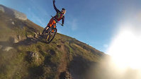
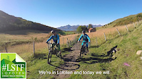
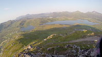
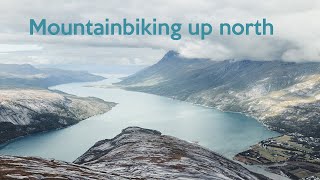
Photos of Leknes Mountain Bike
Videos of Leknes Mountain Bike
trail: Smørdalskammen
0:12 |
447 |
Jul 19, 2019
trail: Smørdalskammen
3:36 |
3139 |
Sep 19, 2016
trail: Eltofttuva
0:23 |
354 |
Nov 18, 2014
trail: Justadtinden
2:56 |
207 |
Apr 20, 2024 , Leknes
Recent Trail Reports
| status | trail | date | condition | info | user |
|---|---|---|---|---|---|
| Smørdalskammen | Jun 24, 2026 @ 5:47pm (Europe/Oslo) Jun 24, 2026 | Ideal | Roy-w | ||
| Rundt Lindalsvatnet | Aug 25, 2025 @ 3:34pm Aug 25, 2025 | Dry | BrokenHandlebar PHP | ||
| Justadtinden | Aug 22, 2024 @ 9:29am Aug 22, 2024 | Variable | Bikesenf | ||
| Gamle Uttakleivvei Downhill | Jun 21, 2023 @ 7:28am Jun 21, 2023 | Dry | JohannesE | ||
| Gamle Uttakleivvei | Jun 21, 2023 @ 7:28am Jun 21, 2023 | Dry | JohannesE | ||
| Vetten | Jun 14, 2023 @ 12:59pm Jun 14, 2023 | Dry | Bushwacko | ||
| Torvhaugen-Borgvatnet | Oct 27, 2021 @ 8:36am Oct 27, 2021 | Wet | Lofotlarsen | ||
| Rundtur Ride | Oct 27, 2021 @ 8:36am Oct 27, 2021 | Wet | Lofotlarsen | ||
| Markstubben | Sep 20, 2021 @ 8:45am Sep 20, 2021 | Ideal | Lofotlarsen | ||
| Finnkjerka-Alstad | Aug 27, 2019 @ 7:33am Aug 27, 2019 | Dry | kamila-qru |
Activity Feed
| username | action | type | title | date |
|---|---|---|---|---|
| Roy-w | comment | trail | activity #97701265 | Jun 24, 2026 @ 8:52am Jun 24, 2026 |
| Roy-w | add | report | activity #97700857 | Jun 24, 2026 @ 8:47am Jun 24, 2026 |
| Roy-w | ridden | trail | activity #97700796 and 1 more | Jun 24, 2026 @ 8:46am Jun 24, 2026 |
| chriguc | add | report | activity #97094586 | Jun 16, 2026 @ 1:52am Jun 16, 2026 |
| MqHnQ | wishlist | trail | activity #96828982 | Jun 12, 2026 @ 2:43pm Jun 12, 2026 |
Recent Comments
| username | type | title | comment | date |
|---|---|---|---|---|
| trail | Hikeabike up for 90%. I left my bike 1 km... | Jun 24, 2026 @ 8:52am Jun 24, 2026 | ||
| trail | Definely Not blue. More Red or black. Gets... | Aug 23, 2025 @ 12:36pm Aug 23, 2025 | ||
| trail | Very nice Trail. View at the top is a dream.... | Aug 23, 2025 @ 12:34pm Aug 23, 2025 | ||
| trail | Definitely not blue. Nice hike though. | Jul 30, 2025 @ 1:21pm Jul 30, 2025 | ||
| trail | This is a hike trail not suitable for biking.... | Jul 5, 2024 @ 8:54am Jul 5, 2024 |
Local Badges
-

Epic Mountain Bike Climb 2k11 awarded -

Climbing 10k Badge3 awarded -

Mountain Biking 100k Badge1 awarded -

Epic Ride Descent 2k11 awarded -

Descent 10k Badge3 awarded -

Descent 100k Badge1 awarded
Activity Type Stats
| activitytype | trails | distance | descent | descent distance | total vertical | rating | global rank | state rank | photos | reports | routes | ridelogs |
|---|---|---|---|---|---|---|---|---|---|---|---|---|
| Mountain Bike | 36 | 36 miles | 13,855 ft | 19 miles | 2,274 ft | #3,394 | #31 | 24 | 28 | 1,975 | ||
| E-Bike | 11 | 14 miles | 3,409 ft | 6 miles | 1,434 ft | #2,193 | #31 | 24 | 199 | |||
| Adaptive Bike | 1 | #3,764 | #17 | |||||||||
| Hike | 33 | 32 miles | 12,362 ft | 17 miles | 2,274 ft | #3,107 | #34 | 28 | 2,119 | |||
| Trail Running | 31 | 29 miles | 12,021 ft | 16 miles | 2,274 ft | #2,753 | #35 | 28 | 109 | |||
| Snowshoe | 12 | 13 miles | 5,991 ft | 8 miles | 1,316 ft | #217 | #10 | 6 | ||||
| Nordic Ski | 11 | 3 | 89 |
Frequently Asked Questions About Leknes
▼
What are the best places to ride in Leknes?
Leknes has 1 areas to explore for mountain biking. The top rated areas are:
▼
What are the highest rated mountain biking trails in Leknes?
The highest rated mountain biking trails in Leknes are:
- Tjønndalen to Løvdal (4.1/5)
- Hellmyran (4/5)
- Hagskaret Ned (3.9/5)
- Vetten (3.8/5)
- Smørdalskammen (3.7/5)
▼
What is the best time of the year to ride in Leknes?
Based on ride log data, the most popular months to ride in Leknes are:
- July (9 activities)
- August (4 activities)
- September (3 activities)
▼
Where can I park to ride in Leknes?
Trails
Points of Interest
- By canadaka
 Trailforks & contributors
 - Admins: apply
- #9252 - 4,885 views
- leknes activity log | embed map of Leknes mountain bike trails | leknes mountain biking points of interest
Downloading of trail gps tracks in kml & gpx formats is enabled for Leknes.
You must login to download files.