close
-
Layers w
- Weather Layers
- Pro
- Pro
- Pro
- Pro
- Pro
- Pro
- More Layers
- Pro
- Pro
- Pro
- Pro
-
Upgrade to

3D
Trail Conditions
- Unknown
- Snow Groomed
- Snow Packed
- Snow Covered
- Snow Cover Partial
- Freeze/thaw Cycle
- Icy
- Prevalent Mud
- Wet
- Variable
- Ideal
- Dry
- Very Dry
Trail Flow (Ridden Direction)
Trailforks scans users ridelogs to determine the most popular direction each trail is ridden. A good flowing trail network will have most trails flowing in a single direction according to their intension.
The colour categories are based on what percentage of riders are riding a trail in its intended direction.
The colour categories are based on what percentage of riders are riding a trail in its intended direction.
- > 96%
- > 90%
- > 80%
- > 70%
- > 50%
- < 50%
- bi-directional trail
- no data
Trail Last Ridden
Trailforks scans ridelogs to determine the last time a trail was ridden.
- < 2 days
- < 1 week
- < 2 weeks
- < 1 month
- < 6 months
- > 6 months
Trail Ridden Direction
The intended direction a trail should be ridden.
- Downhill Only
- Downhill Primary
- Both Directions
- Uphill Primary
- Uphill Only
- One Direction
Contribute Details
Colors indicate trail is missing specified detail.
- Description
- Photos
- Description & Photos
- Videos
Trail Popularity ?
Trailforks scans ridelogs to determine which trails are ridden the most in the last 9 months.
Trails are compared with nearby trails in the same city region with a possible 25 colour shades.
Think of this as a heatmap, more rides = more kinetic energy = warmer colors.
- most popular
- popular
- less popular
- not popular
ATV/ORV/OHV Filter
Max Vehicle Width
inches
US Cell Coverage
Legend

Radar Time
Activity Recordings
Trailforks uses anonymized public activity data.
?
Activity Recordings
Trailforks uses anonymized public activity data.
?
Personal Heatmap
▶
Activity Types
all
/
none
▶
Options
2
Date range
month
–
Winter Trails
Warning
A routing network for winter maps does not exist. Selecting trails using the winter trails layer has been disabled.
Missing Trails
Most Popular
Least Popular
Trails are colored based on popularity. The more popular a trail is, the more red. Less popular trails trend towards green.
Jump Magnitude Heatmap
Heatmap of where riders jump on trails. Zoom in to see individual jumps, click circles to view jump details.
BC Backroad Status
![map legend]()
Service Road Atlas is a free to use, community-driven service for viewing and creating reports on the numerous back-country service roads around B.C. and Alberta.

Slope Aspect
Direction the slope faces
Trails Deemphasized
Trails are shown in grey.
Only show trails with no bike usage.
Suggested Layers
Based on selected activity type
Save the current map location and zoom level as your default home location whenever this page is loaded.
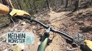
SaveThe Clarence Mountain Bike Park and the Meehan Range Recreation Area form a rich network of MTB trails which are developed largely by volunteer efforts in conjunction with the Clarence Council. The Meehan Monster mountain bike race (started in 2014) is hosted here in October.
New trails are being added all the time
New trails are being added all the time
Primary Trail Type: Cross-Country
AKA: Clarence MTB park
Land Status: City Managed
 google parking directions
Links
Activities Click to view
- Mountain Bike
109 trails
- E-Bike
100 trails
- Horse
4 trails
- Hike
69 trails
- Trail Running
69 trails
Region Details
- 10
- 1
- 26
- 42
- 7
- 1
Region Status
Open as of 13 hoursStats
- Avg Trail Rating
- Trails (view details)
- 88
- Trails Mountain Bike
- 109
- Trails E-Bike
- 100
- Trails Horse
- 4
- Trails Hike
- 69
- Trails Trail Running
- 69
- Total Distance
- 36 miles
- Total Descent
- 7,322 ft
- Total Vertical
- 1,199 ft
- Highest Trailhead
- 1,248 ft
- Reports
- 1,712
- Photos
- 115
- Ridden Counter
- 40,281
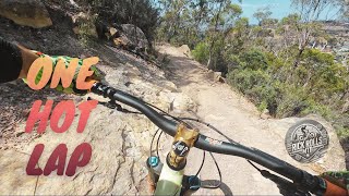
Popular Meehan Range Mountain Biking Trails
• 100 ★ 3.7 • 4,423 ft • 254 ft • 921 •
An easy and pleasant climbing trail out of the MTB Park and west towards (connector to the ), XC Descent and the Belbins Road area of the Meehan Range trail network.
• 100 ★ 4.2 • 1,503 ft • 0 ft • 885 •
A beginner's jump line that allows novice riders to keep their wheels on the dirt if they choose to.
C5 Permanently Closed
• 100 ★ 3.0 • 1,175 ft • 37 ft • 882 •
Popular blue difficulty closed singletrack. This mountain bike primary trail can be used downhill primary and has a moderate overall physical rating. It features jump. On average it takes 1 minutes to complete this trail.
C4 Permanently Closed
• 100 ★ 3.4 • 643 ft • 4 ft • 861 •
Popular blue difficulty closed singletrack. This mountain bike primary trail can be used downhill primary and has a easy overall physical rating. It features berm. On average it takes minutes to complete this trail.
• 100 ★ 4.6 • 4,399 ft • 354 ft • 809 •
A wide trail with a moderately gentle grade for most of its length makes this an easy alternate climb to the top of . There are views along the way making it a pleasant easy ride. Being a wide trail the sightlines are mostly good for...
• 95 ★ 5.0 • 2,602 ft • 20 ft • 795 •
The original cross country trailsat the Clarence MTB Park - a more technical alternative to
• 100 ★ 3.8 • 2,044 ft • 33 ft • 786 •
The lower section of is slightly gentler but still has a smooth surface and a pump/rhythm feel.
Meehan Range Mountain Bike Routes
2 miles • 41 ft • 2 •
Tas Gravity Enduro Series 2023/24 Round 1 Clarence MTB Park. Special Stage 3, Cooper head Rd to Back of...
★ 3.7 • 15 miles • 2,468 ft • 0 • Loop •
HELD AT CLARENCE MTB PARK ON OCTOBER 25TH 2015 THE MEEHAN MONSTER IS A 1, 2 OR 3 LAP RACE. THE TWIST IS...
2 miles • 190 ft • 11 • Loop •
A great loop for novice riders or first time visitors to the Clarence MTB Park. A mixture of easy climbs,...
10 miles • 1,585 ft • 24 • Loop •
An enjoyable short to medium length loop. To find the start of the first trail, park at the end of Belbins...
12 miles • 1,778 ft • 57 • Loop •
Start off at the Mornington carpark. Loop up via XC upper, continue into Belbins and get to Birthday as...
8 miles • 1,217 ft • 22 • Loop •
Just testing some ideas for loops - new to the area, happy for ideas!
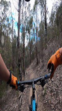
Photos of Meehan Range Mountain Bike
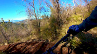
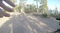
Videos of Meehan Range Mountain Bike
trail: Death Log
0:18 |
170 |
Oct 6, 2021
trail: Nutella
0:00 |
242 |
Dec 17, 2019
trail: Corkscrew
5:10 |
180 |
Jun 5, 2019

trail: Barilla Rivulet Fire Trail
5:46 |
275 |
Oct 6, 2018
trail: Skills Area
0:09 |
639 |
Feb 26, 2017
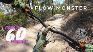
trail: Flow Monster
0:02 |
17 |
Jun 14, 2026 , Hobart
trail: K's choice
3:28 |
18 |
Jun 14, 2026 , Hobart
trail: Simmons Hill Descent
0:18 |
7 |
Jun 14, 2026 , Hobart
Recent Trail Reports
| status | trail | date | condition | info | user |
|---|---|---|---|---|---|
| C3 | Jul 7, 2026 @ 1:25pm (Australia/Hobart) Jul 6, 2026 | Variable | gkalis | ||
| Meehan Skyline Trail | Jul 7, 2026 @ 1:25pm (Australia/Hobart) Jul 6, 2026 | Variable | gkalis | ||
| The Rock Wall | Jul 7, 2026 @ 1:25pm (Australia/Hobart) Jul 6, 2026 | Unknown | gkalis | ||
| Car Park Connector | Jul 7, 2026 @ 1:25pm (Australia/Hobart) Jul 6, 2026 | Variable | gkalis | ||
| Skills Area | Jul 7, 2026 @ 1:25pm (Australia/Hobart) Jul 6, 2026 | Ideal | gkalis | ||
| Jack Jumper | Jul 7, 2026 @ 1:25pm (Australia/Hobart) Jul 6, 2026 | Ideal | gkalis | ||
| MacKillop Track | Jul 7, 2026 @ 1:25pm (Australia/Hobart) Jul 6, 2026 | Variable | gkalis | ||
| Flow Monster's Tail | Jul 7, 2026 @ 1:25pm (Australia/Hobart) Jul 6, 2026 | Variable | gkalis | ||
| XC Loop Lower | Jul 7, 2026 @ 1:25pm (Australia/Hobart) Jul 6, 2026 | Variable | gkalis | ||
| Flow Monster | Jul 7, 2026 @ 1:25pm (Australia/Hobart) Jul 6, 2026 | Ideal | gkalis |
Activity Feed
| username | action | type | title | date |
|---|---|---|---|---|
| Paradox__87 | ridden | trail | activity #98892195 | Jul 10, 2026 @ 5:26pm 1 day |
| gkalis | add | report | activity #98693382 and 26 more | Jul 7, 2026 @ 11:24pm Jul 7, 2026 |
| liam4s1f92 | difficultyvote | trail | activity #97961250 | Jun 27, 2026 @ 10:00pm Jun 27, 2026 |
| maloneyrick | add | video | activity #97023905 and 2 more | Jun 14, 2026 @ 10:41pm Jun 14, 2026 |
| Xznkna | wishlist | region | activity #96827221 | Jun 12, 2026 @ 2:10pm Jun 12, 2026 |
Recent Comments
| username | type | title | comment | date |
|---|---|---|---|---|
| trail | Very fun, not too long, easy to do laps of.... | Jun 6, 2026 @ 12:32am Jun 6, 2026 | ||
| trail | Since the re-vamp it’s been running real nice | Jun 6, 2026 @ 12:28am Jun 6, 2026 | ||
| trail | Track has been greatly improved with recent... | May 30, 2026 @ 9:51pm May 30, 2026 | ||
| trail | I | May 15, 2026 @ 8:39pm May 15, 2026 | ||
| report | Track works | Apr 7, 2026 @ 5:18pm Apr 7, 2026 |
Nearby Areas
| name | distance | ||||
|---|---|---|---|---|---|
| Waverley Flora Reserve | 5 | 2 | 1.8 km | ||
| Geilston Bay | 9 | 10 | 4 | 2.7 km | |
| Pilcher | 6 | 7 | 1 | 3.3 km | |
| Tranmere Hills | 11 | 5 | 3 | 4 km | |
| Queens Domain | 6 | 10 | 4.3 km |
Local Badges
-

Completionist6 awarded
Activity Type Stats
| activitytype | trails | distance | descent | descent distance | total vertical | rating | global rank | state rank | photos | reports | routes | ridelogs |
|---|---|---|---|---|---|---|---|---|---|---|---|---|
| Mountain Bike | 109 | 35 miles | 7,323 ft | 16 miles | 1,198 ft | #127 | #14 | 114 | 1,708 | 9 | 18,554 | |
| E-Bike | 100 | 35 miles | 7,192 ft | 16 miles | 1,198 ft | #877 | #67 | 1 | 1,628 | 5 | 1,689 | |
| Horse | 4 | 6 miles | 886 ft | 2 miles | 958 ft | #347 | #22 | 273 | ||||
| Hike | 69 | 29 miles | 5,007 ft | 11 miles | 1,198 ft | #3,583 | #78 | 1,668 | 42 | |||
| Trail Running | 69 | 29 miles | 5,056 ft | 12 miles | 1,198 ft | #2,697 | #62 | 1,650 | 232 |
Frequently Asked Questions About Meehan Range
▼
What are the highest rated mountain biking trails in Meehan Range?
The highest rated mountain biking trails in Meehan Range are:
- Flow Monster (4.4/5)
- XC Loop Lower (4.4/5)
- Simmons Hill Descent (4.4/5)
- Cliffhanger (4.4/5)
- Nutella (4.4/5)
▼
What is the best time of the year to ride in Meehan Range?
Based on ride log data, the most popular months to ride in Meehan Range are:
- July (247 activities)
- February (209 activities)
- October (194 activities)
▼
Where can I park to ride in Meehan Range?
There are 3 parking locations listed in Meehan Range. The most popular parking spots are: View all parking and trailhead locations on the map to plan your visit.
▼
What is the longest trail in Meehan Range?
The longest trail in Meehan Range is Acton Road Track South at 4.1 km. View all trails sorted by distance.
Activities
Trails
Points of Interest
- By SchrodingersGat
 MRTG & contributors
 - Admins: Sekt, MRTG
- #9728 - 47,566 views
- meehan range activity log | embed map of Meehan Range mountain bike trails | meehan range mountain biking points of interest
Downloading of trail gps tracks in kml & gpx formats is enabled for Meehan Range.
You must login to download files.