close
-
Layers w
- Weather Layers
- Pro
- Pro
- Pro
- Pro
- Pro
- Pro
- More Layers
- Pro
- Pro
- Pro
- Pro
-
Upgrade to

3D
Trail Conditions
- Unknown
- Snow Groomed
- Snow Packed
- Snow Covered
- Snow Cover Partial
- Freeze/thaw Cycle
- Icy
- Prevalent Mud
- Wet
- Variable
- Ideal
- Dry
- Very Dry
Trail Flow (Ridden Direction)
Trailforks scans users ridelogs to determine the most popular direction each trail is ridden. A good flowing trail network will have most trails flowing in a single direction according to their intension.
The colour categories are based on what percentage of riders are riding a trail in its intended direction.
The colour categories are based on what percentage of riders are riding a trail in its intended direction.
- > 96%
- > 90%
- > 80%
- > 70%
- > 50%
- < 50%
- bi-directional trail
- no data
Trail Last Ridden
Trailforks scans ridelogs to determine the last time a trail was ridden.
- < 2 days
- < 1 week
- < 2 weeks
- < 1 month
- < 6 months
- > 6 months
Trail Ridden Direction
The intended direction a trail should be ridden.
- Downhill Only
- Downhill Primary
- Both Directions
- Uphill Primary
- Uphill Only
- One Direction
Contribute Details
Colors indicate trail is missing specified detail.
- Description
- Photos
- Description & Photos
- Videos
Trail Popularity ?
Trailforks scans ridelogs to determine which trails are ridden the most in the last 9 months.
Trails are compared with nearby trails in the same city region with a possible 25 colour shades.
Think of this as a heatmap, more rides = more kinetic energy = warmer colors.
- most popular
- popular
- less popular
- not popular
ATV/ORV/OHV Filter
Max Vehicle Width
inches
US Cell Coverage
Legend

Radar Time
Activity Recordings
Trailforks uses anonymized public activity data.
?
Activity Recordings
Trailforks uses anonymized public activity data.
?
Personal Heatmap
▶
Activity Types
all
/
none
▶
Options
2
Date range
month
–
Winter Trails
Warning
A routing network for winter maps does not exist. Selecting trails using the winter trails layer has been disabled.
Missing Trails
Most Popular
Least Popular
Trails are colored based on popularity. The more popular a trail is, the more red. Less popular trails trend towards green.
Jump Magnitude Heatmap
Heatmap of where riders jump on trails. Zoom in to see individual jumps, click circles to view jump details.
BC Backroad Status
![map legend]()
Service Road Atlas is a free to use, community-driven service for viewing and creating reports on the numerous back-country service roads around B.C. and Alberta.

Slope Aspect
Direction the slope faces
Trails Deemphasized
Trails are shown in grey.
Only show trails with no bike usage.
Suggested Layers
Based on selected activity type
Save the current map location and zoom level as your default home location whenever this page is loaded.
Save
No description for Morbegno has been added yet!
Login or register to submit one.
This region uses the Uk/Euro style trail grading system.
Activities Click to view
- Mountain Bike
101 trails
- E-Bike
75 trails
- Gravel Bike
0 trails
- Adaptive Bike
0 trails
- Winter Fat Bike
0 trails
- Hike
97 trails
- Trail Running
96 trails
Region Details
- 12
- 11
- 39
- 1
Region Status
Open as of Jul 7, 2026Stats
- Avg Trail Rating
- Trails (view details)
- 99
- Trails Mountain Bike
- 101
- Trails E-Bike
- 75
- Trails Hike
- 97
- Trails Trail Running
- 96
- Trails Snowshoe
- 1
- Trails Backcountry Ski
- 1
- Total Distance
- 93 miles
- Total Descent
- 59,255 ft
- Total Vertical
- 5,819 ft
- Highest Trailhead
- 6,505 ft
- Reports
- 512
- Photos
- 68
- Ridden Counter
- 2,912
Sub Regions
-
Bassa Valtellina
- 6
- 34
- 1
Popular Morbegno Mountain Biking Trails
• 95 ★ 4.5 • 2 miles • 0 ft • 110 •
very fun trail; mainly flow and in the woods. Some technical passage with cicken lines, rock slabs and rock gardens. Few exposed sections, mostly in the woods.
• 100 ★ 4.0 • 2,493 ft • 72 ft • 90 •
Easy and flowy exit to braccobaldo trail
• 5 ★ 3.5 • 4,099 ft • 56 ft • 52 •
Middle part of the Fuin Trail: rocks at the beginning, then straight into a drop jump turn feature that leads to the faster and flowy side of the trail.
• 90 ★ 4.7 • 3,730 ft • 0 ft • 51 •
Lond and flowy singltrails down the woods. A long traverse opens it with some uphill in the rocks before heading to a more fast and flowy gully. Pay attention to the rocks!
• 70 ★ 5.0 • 3,422 ft • 34 ft • 49 •
End of the Fuin Trail, skinny singletrail down to Cosio, some turns and lots of rocks.
• 85 ★ 4.9 • 4,862 ft • 3 ft • 47 •
Flowy funny singletrail with a short climb and a long descent. Can be used all year round
• 95 ★ 4.7 • 2 miles • 0 ft • 46 •
Prima parte dalla cima del monte Baitridana al bivio per Talamona/Arzo. Parte iniziale su fondo di radici, attenzione al bivio secco quando si entra nel bosco fitto. contiene sezioni ripide e alcuni salti costruiti. E' segnato con dei...
• 80 ★ 4.0 • 4,389 ft • 66 ft • 46 •
Some fast open turns in the beginning will lead to a bit of technical turns and ends with a fun and fast flowy traverse with some rocks.
Morbegno Mountain Bike Routes
17 miles • 5,025 ft • 7 • Loop •
Long Enduro tour on the beautiful Val Gerola Valley. from alpine meadows down to the valley
21 miles • 6,071 ft • 6 • Loop •
Long Enduro tour on the beautiful Val Gerola Valley.
13 miles • 3,135 ft • 0 •
An easy tour for everybody that leads you to discover the natural beauty of Val Gerola and the secrets...
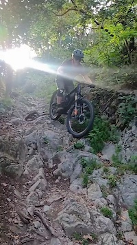
Photos of Morbegno Mountain Bike
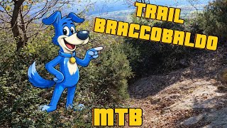
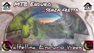
Videos of Morbegno Mountain Bike
0:16 |
85 |
Jul 31, 2023
24:40 |
42 |
Dec 18, 2025 , Morbegno

24:40 |
56 |
Dec 18, 2025 , Morbegno
10:30 |
93 |
Oct 11, 2024 , Morbegno

trail: PX - Power
13:27 |
136 |
Nov 2, 2023 , Morbegno
trail: Taià Trail
126 |
Jun 11, 2023 , Morbegno
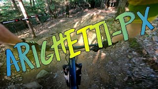
trail: PX
8:59 |
147 |
Jun 10, 2023 , Morbegno

11:56 |
244 |
Jan 16, 2023 , Morbegno
Current Trail Warnings
| status | trail | date | condition | user | info |
|---|---|---|---|---|---|
| Taidadella + Tronchi | Jul 5, 2026 @ 11:21am (Europe/Vaduz) Jul 5, 2026 | Dry | Gianmaria | Trail particolarmente tecnico |
Recent Trail Reports
| status | trail | date | condition | info | user |
|---|---|---|---|---|---|
| PX | Jul 7, 2026 @ 3:31pm (Europe/Rome) Jul 7, 2026 | Variable | ernestosparalesto | ||
| PX - Bagni dell'orso Taia Enduro | Jul 7, 2026 @ 3:30pm (Europe/Rome) Jul 7, 2026 | Ideal | ernestosparalesto | ||
| Taià Trail | Jul 7, 2026 @ 3:28pm (Europe/Rome) Jul 7, 2026 | Variable | ernestosparalesto | ||
| Baitridana #1 - Mt. Baitridana - Bivio | Jul 5, 2026 @ 11:21am (Europe/Vaduz) Jul 5, 2026 | Unknown | Gianmaria | ||
| Biketridana #1 | Jul 5, 2026 @ 11:21am (Europe/Vaduz) Jul 5, 2026 | Ideal | Gianmaria | ||
| Livic | Jul 5, 2026 @ 11:21am (Europe/Vaduz) Jul 5, 2026 | Dry | Gianmaria | ||
| Biketridana #3 | Jul 5, 2026 @ 11:21am (Europe/Vaduz) Jul 5, 2026 | Ideal | Gianmaria | ||
| Contessa | May 31, 2026 @ 8:57am (Europe/Vaduz) May 30, 2026 | Dry | ziosem991 | ||
| Baitridana #2 - Bivio - Talamona / Taiadela | May 30, 2026 @ 10:16pm (Europe/Rome) May 30, 2026 | Dry | muldox | ||
| Talamona - Arzo #2 | May 25, 2026 @ 1:30pm (America/Vancouver) May 25, 2026 | Dry | AlbertokKbRr1 |
Activity Feed
| username | action | type | title | date |
|---|---|---|---|---|
| ernestosparalesto | add | report | activity #98636447 and 2 more | Jul 7, 2026 @ 6:28am Jul 7, 2026 |
| Gianmaria | add | report | activity #98537090 and 1 more | Jul 5, 2026 @ 2:26pm Jul 5, 2026 |
| Gianmaria | add | report | activity #98537089 and 2 more | Jul 5, 2026 @ 2:26pm Jul 5, 2026 |
| Gianmaria | ridden | trail | activity #98529061 | Jul 5, 2026 @ 12:42pm Jul 5, 2026 |
| ALF71 | wishlist | trail | activity #96690122 | Jun 10, 2026 @ 12:30pm Jun 10, 2026 |
Recent Comments
| username | type | title | comment | date |
|---|---|---|---|---|
| report | Nono fondo terroso/sassi. Niente mulattiera | Jun 1, 2026 @ 12:51am Jun 1, 2026 | ||
| report | Ciao, il sentiero in questione è... | May 26, 2026 @ 10:07am May 26, 2026 | ||
| report | Grazie 😍 | Nov 14, 2025 @ 5:47am Nov 14, 2025 | ||
| trail | Non è un trail vero e proprio, è... | Nov 10, 2025 @ 12:46am Nov 10, 2025 | ||
| trail | Forse è la memoria che mi inganna, ma io non... | Nov 10, 2025 @ 12:40am Nov 10, 2025 |
Local Badges
-

10 Blue Trails26 awarded -

Epic Ride Climb 2k224 awarded -

Climbing 10k Badge39 awarded -

Climbing 100k Badge1 awarded -

Epic Ride Descent 2k247 awarded -

Descent 10k Badge41 awarded
Bike & Skill Parks
| name | type | city | rating |
|---|---|---|---|
| Pumptruck Cosio Valtellino | skill park | Morbegno |
Activity Type Stats
| activitytype | trails | distance | descent | descent distance | total vertical | rating | global rank | state rank | photos | reports | routes | ridelogs |
|---|---|---|---|---|---|---|---|---|---|---|---|---|
| Mountain Bike | 101 | 93 miles | 59,255 ft | 63 miles | 5,820 ft | #1,521 | #47 | 63 | 512 | 15 | 3,362 | |
| E-Bike | 75 | 74 miles | 37,657 ft | 46 miles | 5,820 ft | #1,576 | #174 | 3 | 468 | 13 | 1,673 | |
| Hike | 97 | 85 miles | 55,220 ft | 59 miles | 5,820 ft | #2,003 | #69 | 2 | 503 | 3 | 409 | |
| Trail Running | 96 | 83 miles | 53,786 ft | 57 miles | 5,820 ft | #1,711 | #56 | 503 | 363 | |||
| Snowshoe | 1 | 4 miles | 2,077 ft | 4 miles | 2,077 ft | 2 | ||||||
| Backcountry Ski | 1 | 4 miles | 2,077 ft | 4 miles | 2,077 ft | 8 |
Frequently Asked Questions About Morbegno
▼
What are the best places to ride in Morbegno?
Morbegno has 1 areas to explore for mountain biking. The top rated areas are:
▼
What are the highest rated mountain biking trails in Morbegno?
The highest rated mountain biking trails in Morbegno are:
- Valle Oscura (4.5/5)
- Fuin 2.0 - Upper part (4.4/5)
- Braccobaldo / sentiero Bonatti (4.3/5)
- Pippobaldo (4.3/5)
- PX - Bagni dell'orso Taia Enduro (4.3/5)
▼
What is the best time of the year to ride in Morbegno?
Based on ride log data, the most popular months to ride in Morbegno are:
- June (14 activities)
- September (13 activities)
- July (10 activities)
▼
Where can I park to ride in Morbegno?
Check the Morbegno trail map for trailhead and parking information. Community members regularly update access and parking details for trails in the area.
Activities
Trails
- By simonebon 360ValtBike & contributors
- Admins: marcoangeletti, adessoomaipiu, micheletraversi
- #14514 - 4,781 views
- morbegno activity log | embed map of Morbegno mountain bike trails | morbegno mountain biking points of interest
Downloading of trail gps tracks in kml & gpx formats is enabled for Morbegno.
You must login to download files.