close
-
Layers w
- Weather Layers
- Pro
- Pro
- Pro
- Pro
- Pro
- Pro
- More Layers
- Pro
- Pro
- Pro
- Pro
-
Upgrade to

3D
Trail Conditions
- Unknown
- Snow Groomed
- Snow Packed
- Snow Covered
- Snow Cover Partial
- Freeze/thaw Cycle
- Icy
- Prevalent Mud
- Wet
- Variable
- Ideal
- Dry
- Very Dry
Trail Flow (Ridden Direction)
Trailforks scans users ridelogs to determine the most popular direction each trail is ridden. A good flowing trail network will have most trails flowing in a single direction according to their intension.
The colour categories are based on what percentage of riders are riding a trail in its intended direction.
The colour categories are based on what percentage of riders are riding a trail in its intended direction.
- > 96%
- > 90%
- > 80%
- > 70%
- > 50%
- < 50%
- bi-directional trail
- no data
Trail Last Ridden
Trailforks scans ridelogs to determine the last time a trail was ridden.
- < 2 days
- < 1 week
- < 2 weeks
- < 1 month
- < 6 months
- > 6 months
Trail Ridden Direction
The intended direction a trail should be ridden.
- Downhill Only
- Downhill Primary
- Both Directions
- Uphill Primary
- Uphill Only
- One Direction
Contribute Details
Colors indicate trail is missing specified detail.
- Description
- Photos
- Description & Photos
- Videos
Trail Popularity ?
Trailforks scans ridelogs to determine which trails are ridden the most in the last 9 months.
Trails are compared with nearby trails in the same city region with a possible 25 colour shades.
Think of this as a heatmap, more rides = more kinetic energy = warmer colors.
- most popular
- popular
- less popular
- not popular
ATV/ORV/OHV Filter
Max Vehicle Width
inches
US Cell Coverage
Legend

Radar Time
Activity Recordings
Trailforks uses anonymized public activity data.
?
Activity Recordings
Trailforks uses anonymized public activity data.
?
Personal Heatmap
▶
Activity Types
all
/
none
▶
Options
2
Date range
month
–
Winter Trails
Warning
A routing network for winter maps does not exist. Selecting trails using the winter trails layer has been disabled.
Missing Trails
Most Popular
Least Popular
Trails are colored based on popularity. The more popular a trail is, the more red. Less popular trails trend towards green.
Jump Magnitude Heatmap
Heatmap of where riders jump on trails. Zoom in to see individual jumps, click circles to view jump details.
BC Backroad Status
![map legend]()
Service Road Atlas is a free to use, community-driven service for viewing and creating reports on the numerous back-country service roads around B.C. and Alberta.

Slope Aspect
Direction the slope faces
Trails Deemphasized
Trails are shown in grey.
Only show trails with no bike usage.
Suggested Layers
Based on selected activity type
Save the current map location and zoom level as your default home location whenever this page is loaded.
Save
No description for Mortimer has been added yet!
Login or register to submit one.
Activities Click to view
- Mountain Bike
11 trails
- E-Bike
1 trails
- Gravel Bike
2 trails
- Adaptive Bike
0 trails
- Winter Fat Bike
1 trails
- Hike
23 trails
- Trail Running
22 trails
Region Details
- 1
- 5
- 5
Region Status
Open as of Mar 28, 2026Stats
- Avg Trail Rating
- Trails (view details)
- 23
- Trails Mountain Bike
- 11
- Trails E-Bike
- 1
- Trails Gravel Bike
- 2
- Trails Winter Fat Bike
- 1
- Trails Horse
- 1
- Trails Hike
- 23
- Trails Trail Running
- 22
- Total Distance
- 55 miles
- Total Descent Distance
- 26 miles
- Total Descent
- 10,822 ft
- Total Vertical
- 4,575 ft
- Highest Trailhead
- 5,902 ft
- Reports
- 320
- Photos
- 73
- Ridden Counter
- 4,510
Sub Regions
-
Wilson Creek
- 5
- 5
Popular Mortimer Mountain Biking Trails
• 100 ★ 4.4 • 3 miles • 281 ft • 524 •
Also known as “21 Jumps,” there are a string of several jumps that begin to appear just after the top and give a nice opportunity for some air. This trail has been around a long time, and was renovated with contracted machine work...
• 95 ★ 4.4 • 4 miles • 166 ft • 471 •
Schoolhouse has received some love. The last 1.5 miles has been renovated and now transitions in and out of original sections of trail that were improved. The trail starts innocently along a ridge then begins to flex it's muscles with...
• 90 ★ 4.3 • 6 miles • 549 ft • 415 •
Highly rated popular black diamond difficulty mixed. This mountain bike primary trail can be used both directions. It features berm, drop and rock garden. On average it takes 1 hour minutes to complete this trail.
• 60 ★ 4.4 • 2 miles • 92 ft • 185 •
features a remote, technical ride following a scenic creek. By itself, Woodruff is a short but enjoyable out and back. Many riders will start a long Wilson's classic by climbing Woodruff to link up to Wilson Ridge (21 Jumps) to . Ride...
• 80 ★ 4.8 • 2 miles • 6 ft • 152 •
Not much singletrack on this short route, but it provides a variety of riding experiences including a nice singletrack descent and a good overall taste of Pisgah.
• 70 ★ 5.0 • 3 miles • 427 ft • 96 •
This is a moderate Green to Blue trail, mostly green with a few blue sections of climbing and descending. When starting from SR90 it is a moderate climb to the intersection of Jackson Knob, then a short steep climb then moderate again...
• 15 ★ 3.0 • 5 miles • 923 ft • 59 •
Less popular black diamond difficulty singletrack. This mountain bike primary trail can be used both directions. On average it takes 1 hour minutes to complete this trail.
• 30 ★ 0.0 • 3 miles • 714 ft • 27 •
Less popular blue difficulty singletrack. This mountain bike primary trail can be used both directions and has a moderate overall physical rating with a 714 ft blue climb. It features rock garden. Trail visibility is always easy to follow.
Mortimer Mountain Bike Routes
5 miles • 402 ft • 2 • Shuttled •
Shuttle option for to
12 miles • 1,477 ft • 2 •
21 jumps to schoolhouse without a shuttle leaving Mortimer Campground. Just follow signs and you'll find...
16 miles • 1,899 ft • 1 • Loop •
Starting at Mortimer Campground ride up Edgemont road to Roseboro Rd, then climb Roseboro past the trail...
33 miles • 4,393 ft • 5 •
This is one way to do Wilson's Creek without shuttling.
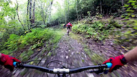
Photos of Mortimer Mountain Bike
Videos of Mortimer Mountain Bike

trail: Yancey Ridge
6:17 |
171 |
May 6, 2021
trail: Yancey Ridge
3:35 |
603 |
Oct 2, 2018
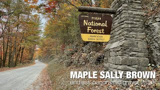
trail: Maple Sally Road
2:53 |
131 |
May 4, 2025 , Mortimer

trail: Schoolhouse Ridge
5:36 |
1027 |
Apr 11, 2022 , Mortimer

trail: Upper Wilson Ridge
2:51 |
520 |
May 18, 2021 , Mortimer
youtuber
![GHETTO TUBELESS vs GNARLIEST TRAIL IN PISGAH...]()

trail: Yancey Ridge
12:12 |
841 |
Jun 14, 2018 , Mortimer
youtuber
![WHEN SKILLS WITH PHIL SAYS A TRAIL IS...]()

trail: Yancey Ridge
12:47 |
1465 |
Jun 12, 2018 , Mortimer
Recent Trail Reports
Activity Feed
| username | action | type | title | date |
|---|---|---|---|---|
| dgmi | ridden | trail | activity #97613657 | Jun 23, 2026 @ 2:28am Jun 23, 2026 |
| hulberp | wishlist | region | activity #97382493 | Jun 20, 2026 @ 4:56am Jun 20, 2026 |
| HollyS0711 | wishlist | route | activity #96744171 and 1 more | Jun 11, 2026 @ 9:44am Jun 11, 2026 |
| E30 | wishlist | route | activity #96363295 | Jun 6, 2026 @ 6:25am Jun 6, 2026 |
| nthemits | ridden | trail | activity #94925887 | May 17, 2026 @ 11:39am May 17, 2026 |
Recent Comments
| username | type | title | comment | date |
|---|---|---|---|---|
| trail | Super fast flow trail. A few optional side hits. | Apr 12, 2026 @ 7:13am Apr 12, 2026 | ||
| trail | The last 1/3 of this trail that climbs up to... | Apr 11, 2026 @ 4:59pm Apr 11, 2026 | ||
| trail | There is now new single track at Mark’s... | Mar 24, 2026 @ 12:33pm Mar 24, 2026 | ||
| trail | As of this writing, the trail is in phenomenal... | Sep 20, 2025 @ 3:07pm Sep 20, 2025 | ||
| trail | Who's removing comments here of updates on... | Oct 29, 2024 @ 12:58pm Oct 29, 2024 |
Local Badges
-

Epic Ride Climb 2k316 awarded -

Climbing 10k Badge68 awarded -

Climbing 100k Badge2 awarded -

Epic Ride Descent 2k322 awarded -

Descent 10k Badge73 awarded -

Descent 100k Badge2 awarded
Activity Type Stats
| activitytype | trails | distance | descent | descent distance | total vertical | rating | global rank | state rank | photos | reports | routes | ridelogs |
|---|---|---|---|---|---|---|---|---|---|---|---|---|
| Mountain Bike | 11 | 32 miles | 7,434 ft | 18 miles | 1,752 ft | #3,957 | #1,333 | 66 | 320 | 9 | 5,401 | |
| E-Bike | 1 | 2 miles | 49 ft | 1,142 ft | 535 ft | #9,754 | #3,030 | 234 | 327 | |||
| Gravel Bike | 2 | 4 miles | 180 ft | 4,590 ft | 663 ft | #655 | #1,145 | 79 | 74 | |||
| Winter Fat Bike | 1 | 3 miles | 741 ft | 2 miles | 463 ft | #426 | #1,170 | 62 | ||||
| Horse | 1 | 2 miles | 3 ft | 348 ft | 719 ft | 47 | ||||||
| Hike | 23 | 55 miles | 10,820 ft | 26 miles | 4,577 ft | #4,454 | #1,571 | 7 | 320 | 382 | ||
| Trail Running | 22 | 55 miles | 10,778 ft | 26 miles | 4,577 ft | #4,190 | #1,277 | 320 | 25 |
Frequently Asked Questions About Mortimer
▼
What are the best places to ride in Mortimer?
Mortimer has 1 areas to explore for mountain biking. The top rated areas are:
▼
What are the highest rated mountain biking trails in Mortimer?
The highest rated mountain biking trails in Mortimer are:
- Lower Wilson Ridge (4.4/5)
- Upper Wilson Ridge (4.3/5)
- Yancey Ridge (4.2/5)
- Schoolhouse Ridge (4.2/5)
- Woodruff Ridge (4.1/5)
▼
What is the best time of the year to ride in Mortimer?
Based on ride log data, the most popular months to ride in Mortimer are:
- October (29 activities)
- June (28 activities)
- September (26 activities)
▼
Where can I park to ride in Mortimer?
There are 16 parking locations listed in Mortimer. The most popular parking spots are: View all parking and trailhead locations on the map to plan your visit.
Trails
Points of Interest
- Cliffside Camp Camping
- Beacon Heights Summit
- Linn Cove Viadutt Viewpoint
- Watauga Viewpoint
- USFS Mortimer Campground Camping
- Indian House Cove Sight
- McRae Peak Summit
- Paito View Viewpoint
- Linville Peak Summit
- Harper Creek Falls Sight
- Grandmother Mountain (4,616 ft)
- Little Bald (4,275 ft)
- Brier Knob (4,085 ft)
- By markholloway
 Trailforks Map Team & contributors
 - Admins: apply
- #12121 - 4,743 views
- mortimer activity log | embed map of Mortimer mountain bike trails | mortimer mountain biking points of interest
Downloading of trail gps tracks in kml & gpx formats is enabled for Mortimer.
You must login to download files.