close
-
Layers w
- Weather Layers
- Pro
- Pro
- Pro
- Pro
- Pro
- Pro
- More Layers
- Pro
- Pro
- Pro
- Pro
-
Upgrade to

3D
Trail Conditions
- Unknown
- Snow Groomed
- Snow Packed
- Snow Covered
- Snow Cover Partial
- Freeze/thaw Cycle
- Icy
- Prevalent Mud
- Wet
- Variable
- Ideal
- Dry
- Very Dry
Trail Flow (Ridden Direction)
Trailforks scans users ridelogs to determine the most popular direction each trail is ridden. A good flowing trail network will have most trails flowing in a single direction according to their intension.
The colour categories are based on what percentage of riders are riding a trail in its intended direction.
The colour categories are based on what percentage of riders are riding a trail in its intended direction.
- > 96%
- > 90%
- > 80%
- > 70%
- > 50%
- < 50%
- bi-directional trail
- no data
Trail Last Ridden
Trailforks scans ridelogs to determine the last time a trail was ridden.
- < 2 days
- < 1 week
- < 2 weeks
- < 1 month
- < 6 months
- > 6 months
Trail Ridden Direction
The intended direction a trail should be ridden.
- Downhill Only
- Downhill Primary
- Both Directions
- Uphill Primary
- Uphill Only
- One Direction
Contribute Details
Colors indicate trail is missing specified detail.
- Description
- Photos
- Description & Photos
- Videos
Trail Popularity ?
Trailforks scans ridelogs to determine which trails are ridden the most in the last 9 months.
Trails are compared with nearby trails in the same city region with a possible 25 colour shades.
Think of this as a heatmap, more rides = more kinetic energy = warmer colors.
- most popular
- popular
- less popular
- not popular
ATV/ORV/OHV Filter
Max Vehicle Width
inches
US Cell Coverage
Legend

Radar Time
Activity Recordings
Trailforks uses anonymized public activity data.
?
Activity Recordings
Trailforks uses anonymized public activity data.
?
Personal Heatmap
▶
Activity Types
all
/
none
▶
Options
2
Date range
month
–
Winter Trails
Warning
A routing network for winter maps does not exist. Selecting trails using the winter trails layer has been disabled.
Missing Trails
Most Popular
Least Popular
Trails are colored based on popularity. The more popular a trail is, the more red. Less popular trails trend towards green.
Jump Magnitude Heatmap
Heatmap of where riders jump on trails. Zoom in to see individual jumps, click circles to view jump details.
BC Backroad Status
![map legend]()
Service Road Atlas is a free to use, community-driven service for viewing and creating reports on the numerous back-country service roads around B.C. and Alberta.

Slope Aspect
Direction the slope faces
Trails Deemphasized
Trails are shown in grey.
Only show trails with no bike usage.
Suggested Layers
Based on selected activity type
Save the current map location and zoom level as your default home location whenever this page is loaded.
Save
No description for Ocala has been added yet!
Login or register to submit one.

IMBA Ride Center
Santos
Activities Click to view
- Mountain Bike
93 trails
- E-Bike
77 trails
- Gravel Bike
7 trails
- Adaptive Bike
1 trails
- Winter Fat Bike
2 trails
- Horse
6 trails
- Hike
84 trails
- Trail Running
84 trails
Region Details
- 6
- 3
- 38
- 19
- 12
- 1
Region Status
Open as of 1 dayStats
- Avg Trail Rating
- Trails (view details)
- 94
- Trails Mountain Bike
- 93
- Trails E-Bike
- 77
- Trails Gravel Bike
- 7
- Trails Adaptive Bike
- 1
- Trails Winter Fat Bike
- 2
- Trails Horse
- 6
- Trails Hike
- 84
- Trails Trail Running
- 84
- Trails Dirtbike/Moto
- 1
- Total Distance
- 165 miles
- Total Descent
- 3,609 ft
- Total Vertical
- 85 ft
- Highest Trailhead
- 115 ft
- Reports
- 3,947
- Photos
- 1,369
- Ridden Counter
- 100,349
Sub Regions
-
Christmas Section
- 1
- 2
-
Ern N Burn
- 5
- 2
- 1
-
Landbridge
- 4
-
Nayl's
- 1
- 2
-
Pruitt Section
- 2
- 3
- 1
-
Santos
- 1
- 10
- 9
- 7
-
Spider Kingdom
- 8
- 2
- 1
-
Vortex
- 5
- 1
- 3
- 1
Popular Ocala Mountain Biking Trails
• 100 ★ 3.0 • 945 ft • 7 ft • 3,454 •
Popular green difficulty singletrack. This multi-use trail can be used both directions and has a easy overall physical rating with a 7 ft green climb. On average it takes 1 minutes to complete this trail.
• 95 ★ 3.6 • 1 mile • 8 ft • 2,787 •
is a blue trail (moderate) in the San Trail System. This trail is accessible from the San Trailhead if you follow in either direction. Depending on which leg of you take, it will put you on opposite ends of . is one of the easier blues...
• 100 ★ 4.3 • 873 ft • 5 ft • 2,636 •
Wooden Berms & Jumps. Fun flowy downhill built by Ray(Ray's Indoor Mountain Bike Parks)
• 85 ★ 4.0 • 3 miles • 73 ft • 2,614 •
The name says it all, a very twisty trail with very good flow. A few humps, maybe 10 feet tall but other than those little elevation change. Turns aren't super tight so maintaining speed is possible with good bike handling skills. Love...
• 90 ★ 3.9 • 2,031 ft • 2 ft • 2,497 •
Popular blue difficulty singletrack. This multi-use trail can be used both directions and has a moderate overall physical rating with a 2 ft blue climb. On average it takes 2 minutes to complete this trail.
• 85 ★ 3.2 • 853 ft • 0 ft • 2,436 •
Popular black diamond difficulty singletrack. This multi-use trail can be used both directions. On average it takes 2 minutes to complete this trail.
• 90 ★ 4.1 • 1 mile • 34 ft • 2,433 •
Highly rated popular blue difficulty singletrack. This multi-use trail can be used both directions and has a moderate overall physical rating with a 34 ft blue climb. Trail visibility is always easy to follow. On average it takes 9 minutes to complete this trail.
Ocala Mountain Bike Routes
★ 5.0 • 43 miles • 1,145 ft • 24 • Out & Back •
69km or 42miles from parking to Vortex parking and back, all without repeating any trail.
★ 5.0 • 60 miles • 1,126 ft • 59 •
First try at creating an out and back route Santos
★ 3.3 • 16 miles • 504 ft • 38 • Loop •
This is a good route to get a little bit of everything Santos has to offer in about 2 hours for the...
★ 3.0 • 16 miles • 531 ft • 54 • Loop •
Hits most trails in Santos. Pretty difficult, we ate lunch right before we rode around the Vortex area....
73 miles • 1,854 ft • 38 • Point to Point •
Full run through Santos, Vortex, and Spider Kingdom. Features the most fun trails you can ride in Florida...
8 miles • 78 ft • 3 •
The Ride Run Roll Relay is an annual event held along the hiking, equestrian, and mountain bike trails of...
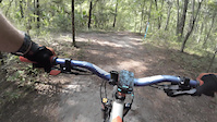
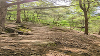
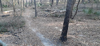
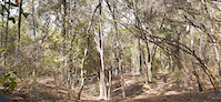
Photos of Ocala Mountain Bike
Videos of Ocala Mountain Bike
trail: Wheee Doggie
0:06 |
31 |
Sep 14, 2025

trail: John Brown
0:13 |
|
Apr 8, 2024
trail: John Brown
0:13 |
|
Mar 8, 2024

trail: Cross Florida Greenway
0:31 |
|
Mar 7, 2023
trail: Christmas Trail
0:16 |
|
Mar 6, 2023
trail: Nayls North
0:17 |
|
Mar 6, 2023
trail: John Brown
0:11 |
291 |
Feb 21, 2022

trail: Dr. Ruth
0:27 |
231 |
Jan 11, 2021
Recent Trail Reports
| status | trail | date | condition | info | user |
|---|---|---|---|---|---|
| Cow Bone | Jun 18, 2026 @ 1:22pm (America/Nassau) 1 day | Ideal | CrazyBabsMTBer | ||
| TOS | Jun 16, 2026 @ 8:31am (America/New_York) Jun 16, 2026 | Ideal | Orangecycle1 | ||
| Vortex Access | Jun 16, 2026 @ 8:31am (America/New_York) Jun 16, 2026 | Dry | Orangecycle1 | ||
| Dogtail Trail | Jun 16, 2026 @ 8:31am (America/New_York) Jun 16, 2026 | Ideal | Orangecycle1 | ||
| Spider Kingdom North | Jun 16, 2026 @ 8:31am (America/New_York) Jun 16, 2026 | Ideal | Orangecycle1 | ||
| Parking Access Road | Jun 16, 2026 @ 8:31am (America/New_York) Jun 16, 2026 | Ideal | Orangecycle1 | ||
| Barnes North | Jun 16, 2026 @ 8:31am (America/New_York) Jun 16, 2026 | Dry | Orangecycle1 | ||
| Barns Trail South | Jun 16, 2026 @ 8:31am (America/New_York) Jun 16, 2026 | Ideal | Orangecycle1 | ||
| Widow Maker | Jun 16, 2026 @ 8:31am (America/New_York) Jun 16, 2026 | Ideal | Orangecycle1 | ||
| Spider Kingdom South Spur | Jun 16, 2026 @ 8:31am (America/New_York) Jun 16, 2026 | Dry | Orangecycle1 |
Activity Feed
| username | action | type | title | date |
|---|---|---|---|---|
| CrazyBabsMTBer | add | report | activity #97270826 | Jun 18, 2026 @ 12:46pm 1 day |
| Orangecycle1 | add | report | activity #97131604 and 1 more | Jun 16, 2026 @ 12:36pm Jun 16, 2026 |
| Orangecycle1 | add | report | activity #97131601 and 3 more | Jun 16, 2026 @ 12:36pm Jun 16, 2026 |
| Orangecycle1 | add | report | activity #97131599 and 4 more | Jun 16, 2026 @ 12:36pm Jun 16, 2026 |
| Orangecycle1 | add | report | activity #97131597 and 2 more | Jun 16, 2026 @ 12:36pm Jun 16, 2026 |
Recent Comments
| username | type | title | comment | date |
|---|---|---|---|---|
| report | A1 | May 22, 2026 @ 12:15pm May 22, 2026 | ||
| report | Mailbox in the middle of nowhere | May 22, 2026 @ 12:15pm May 22, 2026 | ||
| trail | Sw | Jul 24, 2025 @ 5:16pm Jul 24, 2025 | ||
| trail | Trail is closed indefinitely, infinity takes... | Jul 24, 2025 @ 5:16pm Jul 24, 2025 | ||
| trail | Very cool trail, narrow windy climb, then... | May 14, 2025 @ 6:04am May 14, 2025 |
Local Badges
-

10 Green Trails1,070 awarded -

10 Blue Trails1,261 awarded -

Epic Ride Climb 2k19 awarded -

Climbing 10k Badge81 awarded -

Climbing 100k Badge3 awarded -

Epic Ride Descent 2k19 awarded
Bike & Skill Parks
| name | type | city | rating |
|---|---|---|---|
| Santos Skill Park | skill park | Ocala | |
| Vortex | skill park | Ocala | |
| Hardrock Cycle Park | skill park | Ocala | |
| Motocross of Marion County | skill park | Ocala |
Activity Type Stats
| activitytype | trails | distance | descent | descent distance | total vertical | rating | global rank | state rank | photos | reports | routes | ridelogs |
|---|---|---|---|---|---|---|---|---|---|---|---|---|
| Mountain Bike | 93 | 123 miles | 2,867 ft | 32 miles | 85 ft | #160 | #60 | 1,360 | 3,945 | 20 | 63,936 | |
| E-Bike | 77 | 110 miles | 2,375 ft | 29 miles | 85 ft | #772 | #759 | 1 | 3,910 | 5 | 3,768 | |
| Gravel Bike | 7 | #371 | #964 | 8 | 1 | 251 | ||||||
| Adaptive Bike | 1 | #363 | #1,690 | 1 | 2 | |||||||
| Winter Fat Bike | 2 | #244 | #1,023 | 6 | ||||||||
| Horse | 6 | 28 miles | 515 ft | 9 miles | 52 ft | #542 | #513 | 4 | 420 | 97 | ||
| Hike | 84 | 135 miles | 2,648 ft | 35 miles | 85 ft | #653 | #299 | 3 | 3,890 | 938 | ||
| Trail Running | 84 | 135 miles | 2,648 ft | 35 miles | 85 ft | #1,202 | #434 | 2 | 3,890 | 1 | 539 | |
| Dirtbike/Moto | 1 | 3,743 ft | 3 ft | 433 ft | 10 ft | 419 | 39 |
Frequently Asked Questions About Ocala
▼
What are the best places to ride in Ocala?
Ocala has 10 areas to explore for mountain biking. The top rated areas are:
▼
What are the highest rated mountain biking trails in Ocala?
The highest rated mountain biking trails in Ocala are:
- Vortex (4.5/5)
- Troll (4.5/5)
- Indigo Flow (4.4/5)
- Widow Maker (4.3/5)
- Bryar Patch (4.3/5)
▼
What is the best time of the year to ride in Ocala?
Based on ride log data, the most popular months to ride in Ocala are:
- February (1,005 activities)
- March (933 activities)
- December (892 activities)
▼
Where can I park to ride in Ocala?
There are 16 parking locations listed in Ocala. The most popular parking spots are:
- Vortex Trailhead Parking
- Santos Trailhead Parking
- Florid Trail Landbridge Trailhead Parking b
- Florida Trail Landbridge Trailhead Parking 1
- Christmas Tree Trailhead
Activities
Trails
- By brenthillier
 NSMBA TRAILFORKS & contributors
 - Admins: OMBA
- #3671 - 18,985 views
- ocala activity log | embed map of Ocala mountain bike trails | ocala mountain biking points of interest
Downloading of trail gps tracks in kml & gpx formats is enabled for Ocala.
You must login to download files.