close
-
Layers w
- Weather Layers
- Pro
- Pro
- Pro
- Pro
- Pro
- Pro
- More Layers
- Pro
- Pro
- Pro
- Pro
-
Upgrade to

3D
Trail Conditions
- Unknown
- Snow Groomed
- Snow Packed
- Snow Covered
- Snow Cover Partial
- Freeze/thaw Cycle
- Icy
- Prevalent Mud
- Wet
- Variable
- Ideal
- Dry
- Very Dry
Trail Flow (Ridden Direction)
Trailforks scans users activity logs to determine the most popular direction each trail is ridden. A good flowing trail network will have most trails flowing in a single direction according to their intension.
The colour categories are based on what percentage of users are riding a trail in its intended direction.
The colour categories are based on what percentage of users are riding a trail in its intended direction.
- > 96%
- > 90%
- > 80%
- > 70%
- > 50%
- < 50%
- bi-directional trail
- no data
Trail Last Ridden
Trailforks scans activity logs to determine the last time a trail was ridden.
- < 2 days
- < 1 week
- < 2 weeks
- < 1 month
- < 6 months
- > 6 months
Trail Ridden Direction
The intended direction a trail should be ridden.
- Downhill Only
- Downhill Primary
- Both Directions
- Uphill Primary
- Uphill Only
- One Direction
Contribute Details
Colors indicate trail is missing specified detail.
- Description
- Photos
- Description & Photos
- Videos
Trail Popularity ?
Trailforks scans activity logs to determine which trails are ridden the most in the last 9 months.
Trails are compared with nearby trails in the same city region with a possible 25 colour shades.
Think of this as a heatmap, more activities = more kinetic energy = warmer colors.
- most popular
- popular
- less popular
- not popular
ATV/ORV/OHV Filter
Max Vehicle Width
inches
US Cell Coverage
Legend

Radar Time
Activity Recordings
Trailforks uses anonymized public activity data.
?
Activity Recordings
Trailforks uses anonymized public activity data.
?
Personal Heatmap
▶
Activity Types
all
/
none
▶
Options
2
Date range
month
–
Winter Trails
Warning
A routing network for winter maps does not exist. Selecting trails using the winter trails layer has been disabled.
Missing Trails
Most Popular
Least Popular
Trails are colored based on popularity. The more popular a trail is, the more red. Less popular trails trend towards green.
Jump Magnitude Heatmap
Heatmap of where users jump on trails. Zoom in to see individual jumps, click circles to view jump details.
BC Backroad Status
![map legend]()
Service Road Atlas is a free to use, community-driven service for viewing and creating reports on the numerous back-country service roads around B.C. and Alberta.

Slope Aspect
Direction the slope faces
Trails Deemphasized
Trails are shown in grey.
Only show trails with no bike usage.
Suggested Layers
Based on selected activity type
Save the current map location and zoom level as your default home location whenever this page is loaded.
SavePace Bend Park is located in far western Travis County in the Hill Country of central Texas. With more than nine miles of shoreline along scenic Lake Travis, Pace Bend is one of the most popular areas in the Highland Lakes region, offering visitors a wide range of recreational opportunities. The west side of the park features high, limestone cliffs and numerous rocky coves with some of the most impressive views available of Lake Travis, especially at sunset.
Most of Pace Bend Park is easily accessible by vehicle from the six-mile, paved roadway that loops the park. However, the interior of the park is managed as a wildlife preserve and can be reached by foot, bicycle, or horseback only. Numerous trails lead into the hills and provide excellent views of the lake and the Hill Country. This area serves as home to a large number of whitetail deer, raccoon, fox, ringtail cat, and dozens of bird species.
Most of Pace Bend Park is easily accessible by vehicle from the six-mile, paved roadway that loops the park. However, the interior of the park is managed as a wildlife preserve and can be reached by foot, bicycle, or horseback only. Numerous trails lead into the hills and provide excellent views of the lake and the Hill Country. This area serves as home to a large number of whitetail deer, raccoon, fox, ringtail cat, and dozens of bird species.
source: Travis County Parks
Primary Trail Type: Cross-Country
Land Status: County Park
Land Manager: Travis County Parks
 google parking directions
Links
Region Supporters & Maintainers
![]()
Austin Ridge Riders Mountain Bike Club
since 2023Maintainer
Activities Click to view
- Mountain Bike
46 trails
- E-Bike
47 trails
- Hike
47 trails
- Trail Running
47 trails
Region Details
- 3
- 27
- 14
- 1
Region Status
Open as of Aug 17, 2025Local Trail Association
Stats
- Avg Trail Rating
- Trails (view details)
- 45
- Trails Mountain Bike
- 47
- Trails E-Bike
- 47
- Trails Horse
- 1
- Trails Hike
- 47
- Trails Trail Running
- 47
- Total Distance
- 21 miles
- Total Descent
- 1,463 ft
- Total Vertical
- 200 ft
- Highest Trailhead
- 883 ft
- Reports
- 218
- Photos
- 55
- Completed Counter
- 12,321
Popular Pace Bend Mountain Biking Trails
• 85 ★ 3.8 • 3 miles • 214 ft • 673 •
Three miles of intermediate challenge including rock gardens and tree gates. There are a few loop extensions to this trail, Including ' ’, a Black Diamond test of balance. after crosses ‘abbey road’, the riding surface gets much...
• 85 ★ 3.5 • 3,787 ft • 57 ft • 631 •
Popular green difficulty singletrack. This multi-use trail can be used both directions. On average it takes 6 minutes to complete this trail.
• 85 ★ 0.0 • 4,783 ft • 15 ft • 589 •
Popular blue difficulty singletrack. This multi-use trail can be used both directions. On average it takes 7 minutes to complete this trail.
• 85 ★ 0.0 • 3,376 ft • 84 ft • 575 •
The south end of this trail is flat and easy. The north end has a punchy challenging climb.
• 90 ★ 4.7 • 1,863 ft • 29 ft • 571 •
Popular blue difficulty singletrack. This multi-use trail can be used both directions. On average it takes 2 minutes to complete this trail.
• 90 ★ 4.0 • 1,027 ft • 14 ft • 566 •
Popular blue difficulty singletrack. This multi-use trail can be used both directions. On average it takes 1 minutes to complete this trail.
• 80 ★ 4.4 • 1 mile • 60 ft • 512 •
Popular blue difficulty singletrack. This multi-use trail can be used both directions. On average it takes 9 minutes to complete this trail.
• 80 ★ 4.0 • 4,465 ft • 28 ft • 472 •
Major Rock Garden Alert! one of the more challenging trails in the park due the many rock gardens. The "parallel" section of is a much easier and shorter option with similar end points.
Pace Bend Mountain Bike Routes
★ 5.0 • 10 miles • 556 ft • 12 •
This loop hits the best of Pace Bend from to Tapework and Paleface. It also passes by the little skills...
★ 3.5 • 8 miles • 459 ft • 10 •
Route for ARR Cranksgiving at Pace Bend Park
★ 5.0 • 7 miles • 323 ft • 5 • Loop •
The Lake Travis MTB NICA (National Interscholastic Cycling Association) Coaches have put together this...
7 miles • 343 ft • 5 • Loop •
This is a great XC training route for NICA athletes and adults. It makes use of the fire road climbs and...
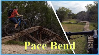
Videos of Pace Bend Mountain Bike
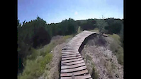
trail: Pace Bend TH
4:14 |
215 |
Dec 16, 2017
trail: Powerline
0:59 |
434 |
Jun 12, 2021 , Austin

trail: Tapeworm
8:19 |
409 |
Feb 1, 2021 , Austin
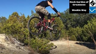
trail: Rock Garden of Greatness
8:19 |
416 |
Feb 1, 2021 , Austin

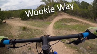
trail: Wookie Way
8:19 |
410 |
Feb 1, 2021 , Austin

trail: Powerline
8:19 |
318 |
Feb 1, 2021 , Austin

trail: Paleface Pass
6:43 |
582 |
May 17, 2020 , Austin
trail: Wookie Way
9:29 |
928 |
May 3, 2020 , Austin
Recent Trail Reports
| status | trail | date | condition | info | user |
|---|---|---|---|---|---|
| Rock Garden of Greatness | Aug 17, 2025 @ 7:49am Aug 17, 2025 | Dry | texmechs | ||
| Connector | Mar 22, 2025 @ 1:55pm Mar 22, 2025 | Ideal | yacapo91 | ||
| Straddle/Lefty Cutoff | Mar 22, 2025 @ 1:55pm Mar 22, 2025 | Ideal | yacapo91 | ||
| Pace Bend TH | Mar 22, 2025 @ 1:55pm Mar 22, 2025 | Ideal | yacapo91 | ||
| Abby Rd / Apache Connector | Mar 22, 2025 @ 1:55pm Mar 22, 2025 | Ideal | yacapo91 | ||
| Pace Bend Access 2 | Nov 16, 2024 @ 1:52pm Nov 16, 2024 | Ideal | yacapo91 | ||
| Pace Bend TH2 | Nov 16, 2024 @ 1:52pm Nov 16, 2024 | Ideal | yacapo91 | ||
| Straddle Yer Saddle | Nov 16, 2024 @ 1:52pm Nov 16, 2024 | Ideal | yacapo91 | ||
| North Croton | Nov 16, 2024 @ 1:52pm Nov 16, 2024 | Dry | yacapo91 | ||
| South Croton | Nov 16, 2024 @ 1:52pm Nov 16, 2024 | Ideal | yacapo91 |
Activity Feed
| username | action | type | title | date |
|---|---|---|---|---|
| txmeowrider | wishlist | trail | activity #99890051 | Jul 24, 2026 @ 7:48am Jul 24, 2026 |
| txmeowrider | wishlist | trail | activity #99489011 | Jul 18, 2026 @ 4:13pm Jul 18, 2026 |
| timgasser | wishlist | route | activity #93999655 | May 3, 2026 @ 5:52pm May 3, 2026 |
| Gustavo1979 | wishlist | route | activity #92022663 | Apr 5, 2026 @ 6:40pm Apr 5, 2026 |
| Gustavo1979 | wishlist | region | activity #92017920 | Apr 5, 2026 @ 5:05pm Apr 5, 2026 |
Recent Comments
| username | type | title | comment | date |
|---|---|---|---|---|
| trail | Almost completely overgrown as of Aug 18th,... | Aug 18, 2025 @ 12:22pm Aug 18, 2025 | ||
| trail | What are useless on MTB comment. Of course... | Sep 23, 2023 @ 9:07am Sep 23, 2023 | ||
| report | O@9 I’m no ok L m ml Zzigiz po | Sep 29, 2021 @ 12:29pm Sep 29, 2021 | ||
| trail | A crazy rock Garden that will definitely test... | Dec 19, 2018 @ 3:05pm Dec 19, 2018 | ||
| trail | A staple of PaleFace park. Part of the annual... | Dec 19, 2018 @ 3:03pm Dec 19, 2018 |
Nearby Areas
| name | distance | ||||
|---|---|---|---|---|---|
| Tessera | 2 | 6 | 1 | 2.4 km | |
| Muleshoe Bend | 3 | 3 | 2 | 5.1 km | |
| Lakeway City Park | 5.9 km | ||||
| Hamilton Greenbelt | 8 | 15 | 2 | 6.5 km | |
| Grelle Recreation Area | 10 | 6.9 km |
Local Badges
-

Completionist9 awarded
Bike & Skill Parks
| name | type | city | rating |
|---|---|---|---|
| Pace Bend Skills Area | skill park | Austin |
Activity Type Stats
| activitytype | trails | distance | descent | descent distance | total vertical | rating | global rank | state rank | photos | reports | routes | activity logs |
|---|---|---|---|---|---|---|---|---|---|---|---|---|
| Mountain Bike | 46 | 21 miles | 1,463 ft | 7 miles | 200 ft | #3,034 | #1,066 | 57 | 218 | 7 | 4,550 | |
| E-Bike | 47 | 21 miles | 1,463 ft | 7 miles | 200 ft | #3,550 | #1,032 | 173 | 3 | 238 | ||
| Horse | 1 | 1 mile | 112 ft | 2,365 ft | 59 ft | 63 | ||||||
| Hike | 47 | 21 miles | 1,463 ft | 7 miles | 200 ft | #6,538 | #2,367 | 218 | 1 | 79 | ||
| Trail Running | 47 | 21 miles | 1,463 ft | 7 miles | 200 ft | #5,635 | 218 | 1 | 71 |
Frequently Asked Questions About Pace Bend
▼
What are the highest rated mountain biking trails in Pace Bend?
The highest rated mountain biking trails in Pace Bend are:
- Wookie Ext 1 (4.2/5)
- Straddle Yer Saddle (4.1/5)
- North Croton (4.1/5)
- South Croton (4.1/5)
- Rock Garden of Greatness (4/5)
▼
What is the best time of the year to ride in Pace Bend?
Based on activity log data, the most popular months to ride in Pace Bend are:
- April (79 activities)
- November (54 activities)
- January (51 activities)
▼
Where can I park to ride in Pace Bend?
There are 2 parking locations listed in Pace Bend. The most popular parking spots are:
▼
What is the longest trail in Pace Bend?
The longest trail in Pace Bend is Wookie Way at 2.9 miles. View all trails sorted by distance.
Activities
- By brenthillier
 NSMBA TRAILFORKS & contributors
 - Admins: ARR, aivort, mtbatx
- #3705 - 28,922 views
- pace bend activity log | embed map of Pace Bend mountain bike trails | pace bend mountain biking points of interest
Downloading of trail gps tracks in kml & gpx formats is enabled for Pace Bend.
You must login to download files.