close
-
Layers w
- Weather Layers
- Pro
- Pro
- Pro
- Pro
- Pro
- Pro
- More Layers
- Pro
- Pro
- Pro
- Pro
-
Upgrade to

3D
Trail Conditions
- Unknown
- Snow Groomed
- Snow Packed
- Snow Covered
- Snow Cover Partial
- Freeze/thaw Cycle
- Icy
- Prevalent Mud
- Wet
- Variable
- Ideal
- Dry
- Very Dry
Trail Flow (Ridden Direction)
Trailforks scans users ridelogs to determine the most popular direction each trail is ridden. A good flowing trail network will have most trails flowing in a single direction according to their intension.
The colour categories are based on what percentage of riders are riding a trail in its intended direction.
The colour categories are based on what percentage of riders are riding a trail in its intended direction.
- > 96%
- > 90%
- > 80%
- > 70%
- > 50%
- < 50%
- bi-directional trail
- no data
Trail Last Ridden
Trailforks scans ridelogs to determine the last time a trail was ridden.
- < 2 days
- < 1 week
- < 2 weeks
- < 1 month
- < 6 months
- > 6 months
Trail Ridden Direction
The intended direction a trail should be ridden.
- Downhill Only
- Downhill Primary
- Both Directions
- Uphill Primary
- Uphill Only
- One Direction
Contribute Details
Colors indicate trail is missing specified detail.
- Description
- Photos
- Description & Photos
- Videos
Trail Popularity ?
Trailforks scans ridelogs to determine which trails are ridden the most in the last 9 months.
Trails are compared with nearby trails in the same city region with a possible 25 colour shades.
Think of this as a heatmap, more rides = more kinetic energy = warmer colors.
- most popular
- popular
- less popular
- not popular
ATV/ORV/OHV Filter
Max Vehicle Width
inches
US Cell Coverage
Legend

Radar Time
Activity Recordings
Trailforks uses anonymized public activity data.
?
Activity Recordings
Trailforks uses anonymized public activity data.
?
Personal Heatmap
▶
Activity Types
all
/
none
▶
Options
2
Date range
month
–
Winter Trails
Warning
A routing network for winter maps does not exist. Selecting trails using the winter trails layer has been disabled.
Missing Trails
Most Popular
Least Popular
Trails are colored based on popularity. The more popular a trail is, the more red. Less popular trails trend towards green.
Jump Magnitude Heatmap
Heatmap of where riders jump on trails. Zoom in to see individual jumps, click circles to view jump details.
BC Backroad Status
![map legend]()
Service Road Atlas is a free to use, community-driven service for viewing and creating reports on the numerous back-country service roads around B.C. and Alberta.

Slope Aspect
Direction the slope faces
Trails Deemphasized
Trails are shown in grey.
Only show trails with no bike usage.
Suggested Layers
Based on selected activity type
Save the current map location and zoom level as your default home location whenever this page is loaded.
SaveHome of the North Saanich Freeride Park.
The region boundaries include the municipalities of Sidney and North Saanich.
The region boundaries include the municipalities of Sidney and North Saanich.
Activities Click to view
- Mountain Bike
10 trails
- E-Bike
8 trails
- Adaptive Bike
0 trails
- Horse
3 trails
- Hike
81 trails
- Trail Running
81 trails
Region Details
- 2
- 5
- 1
- 1
Region Status
Open as of May 23, 2026Stats
- Avg Trail Rating
- Trails (view details)
- 9
- Trails Mountain Bike
- 10
- Trails E-Bike
- 8
- Trails Horse
- 3
- Trails Hike
- 81
- Trails Trail Running
- 81
- Total Distance
- 8 miles
- Total Descent Distance
- 2 miles
- Total Descent
- 167 ft
- Total Vertical
- 85 ft
- Highest Trailhead
- 99 ft
- Reports
- 47
- Photos
- 13
- Ridden Counter
- 5,976
Sub Regions
-
Gulf Islands National Park Reserve
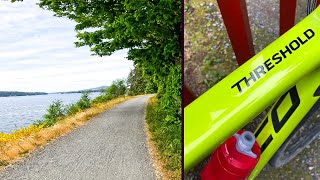
Popular Sidney Mountain Biking Trails
• 100 ★ 3.0 • 2,444 ft • 0 ft • 1,462 •
Popular white difficulty family friendly paved path. This multi-use trail can be used both directions and has a easy overall physical rating with a 0 ft green climb. Trail visibility is always easy to follow. On average it takes 1 minutes to complete this trail.
• 85 ★ 1.0 • 1 mile • 9 ft • 1,144 •
Popular white difficulty family friendly gravel path. This mountain bike primary trail can be used both directions. On average it takes 4 minutes to complete this trail.
• 20 ★ 0.0 • 3,366 ft • 7 ft • 98 •
Less popular white difficulty family friendly paved path. This mountain bike primary trail can be used both directions. On average it takes 3 minutes to complete this trail.
• ★ 0.0 • 2 miles • 116 ft • 1 •
White difficulty paved path. This multi-use trail can be used both directions.
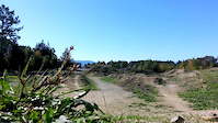
Videos of Sidney Mountain Bike
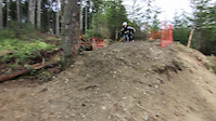
trail: Park Trail
0:04 |
228 |
Feb 16, 2017
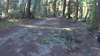
trail: Park Trail
2:01 |
673 |
Feb 11, 2016
0:16 |
217 |
Oct 1, 2015
trail: Lochside Trail - North
21:34 |
39 |
May 13, 2025 , Sidney
0:40 |
254 |
Jun 26, 2024

605 |
Jun 1, 2017
Recent Trail Reports
| status | trail | date | condition | info | user |
|---|---|---|---|---|---|
| Lochside Trail - Swartz Bay Connector | May 23, 2026 @ 8:06am (America/Vancouver) May 23, 2026 | Dry | theprofessionaljerry | ||
| The Flight Path | Oct 21, 2025 @ 6:00pm (America/Vancouver) Oct 21, 2025 | Ideal | babesbikesbeers | ||
| Patrica Bay Path | Sep 27, 2025 @ 1:04pm (America/Vancouver) Sep 27, 2025 | Dry | mpatt | ||
| Lochside Trail - North | Aug 10, 2025 @ 9:40am Aug 10, 2025 | Ideal | raehiti | ||
| Park Trail | Jul 12, 2023 @ 4:35am Jul 12, 2023 | Variable | jeffp5110 | ||
| Connector | Jul 12, 2023 @ 4:35am Jul 12, 2023 | Unknown | jeffp5110 | ||
| Lochside Trail - South | Sep 7, 2021 @ 4:24pm Sep 7, 2021 | Dry | CraigHinCA |
Activity Feed
| username | action | type | title | date |
|---|---|---|---|---|
| theprofessionaljerry | add | report | activity #95406174 | May 24, 2026 @ 7:08am May 24, 2026 |
| CptmorganM | comment | trail | activity #90126523 | Mar 7, 2026 @ 8:12am Mar 7, 2026 |
| HollyNeate | ridden | trail | activity #84872846 | Nov 28, 2025 @ 3:09pm Nov 28, 2025 |
| babesbikesbeers | add | report | activity #82801525 | Oct 21, 2025 @ 8:53pm Oct 21, 2025 |
| mpatt | add | report | activity #81241837 | Sep 27, 2025 @ 3:56pm Sep 27, 2025 |
Recent Comments
| username | type | title | comment | date |
|---|---|---|---|---|
| trail | Non bikes | Mar 7, 2026 @ 8:12am Mar 7, 2026 | ||
| skillpark | best bike park in vic by far | Aug 7, 2020 @ 6:23pm Aug 7, 2020 | ||
| trail | EASY | Aug 7, 2020 @ 6:22pm Aug 7, 2020 | ||
| skillpark | Yep, absolutely | Jul 24, 2020 @ 5:30pm Jul 24, 2020 | ||
| skillpark | beginner friendly? | Jul 23, 2020 @ 10:29pm Jul 23, 2020 |
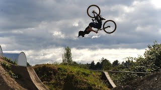
Bike & Skill Parks
| name | type | city | rating |
|---|---|---|---|
| North Saanich Freeride Park | skill park | Sidney |
Activity Type Stats
| activitytype | trails | distance | descent | descent distance | total vertical | rating | global rank | state rank | photos | reports | routes | ridelogs |
|---|---|---|---|---|---|---|---|---|---|---|---|---|
| Mountain Bike | 10 | 8 miles | 167 ft | 2 miles | 85 ft | #7,917 | #148 | 13 | 47 | 11,604 | ||
| E-Bike | 8 | 8 miles | 167 ft | 2 miles | 85 ft | #6,453 | #115 | 47 | 281 | |||
| Horse | 3 | #2,692 | #75 | 2 | ||||||||
| Hike | 81 | 8 miles | 167 ft | 2 miles | 85 ft | #3,619 | #101 | 47 | 3,090 | |||
| Trail Running | 81 | 8 miles | 167 ft | 2 miles | 85 ft | #4,905 | #112 | 47 | 1,795 |
Frequently Asked Questions About Sidney
▼
What are the best places to ride in Sidney?
Sidney has 3 areas to explore for mountain biking.
▼
What are the highest rated mountain biking trails in Sidney?
The highest rated mountain biking trails in Sidney are:
- Lochside Trail - Swartz Bay Connector (3.8/5)
- Lochside Trail - North (3.6/5)
- Lochside Trail - South (0/5)
- Sidney Waterfront Walkway (0/5)
▼
What is the best time of the year to ride in Sidney?
Based on ride log data, the most popular months to ride in Sidney are:
- July (61 activities)
- September (36 activities)
- August (32 activities)
▼
Where can I park to ride in Sidney?
There are 7 parking locations listed in Sidney. The most popular parking spots are: View all parking and trailhead locations on the map to plan your visit.
Activities
Trails
- By gcbeer & contributors
- Admins: Dubnyk, CRD-Parks, NSFRP
- #17766 - 5,518 views
- sidney activity log | embed map of Sidney mountain bike trails | sidney mountain biking points of interest polygons
Downloading of trail gps tracks in kml & gpx formats is enabled for Sidney.
You must login to download files.