close
-
Layers w
- Weather Layers
- Pro
- Pro
- Pro
- Pro
- Pro
- Pro
- More Layers
- Pro
- Pro
- Pro
- Pro
-
Upgrade to

3D
Trail Conditions
- Unknown
- Snow Groomed
- Snow Packed
- Snow Covered
- Snow Cover Partial
- Freeze/thaw Cycle
- Icy
- Prevalent Mud
- Wet
- Variable
- Ideal
- Dry
- Very Dry
Trail Flow (Ridden Direction)
Trailforks scans users ridelogs to determine the most popular direction each trail is ridden. A good flowing trail network will have most trails flowing in a single direction according to their intension.
The colour categories are based on what percentage of riders are riding a trail in its intended direction.
The colour categories are based on what percentage of riders are riding a trail in its intended direction.
- > 96%
- > 90%
- > 80%
- > 70%
- > 50%
- < 50%
- bi-directional trail
- no data
Trail Last Ridden
Trailforks scans ridelogs to determine the last time a trail was ridden.
- < 2 days
- < 1 week
- < 2 weeks
- < 1 month
- < 6 months
- > 6 months
Trail Ridden Direction
The intended direction a trail should be ridden.
- Downhill Only
- Downhill Primary
- Both Directions
- Uphill Primary
- Uphill Only
- One Direction
Contribute Details
Colors indicate trail is missing specified detail.
- Description
- Photos
- Description & Photos
- Videos
Trail Popularity ?
Trailforks scans ridelogs to determine which trails are ridden the most in the last 9 months.
Trails are compared with nearby trails in the same city region with a possible 25 colour shades.
Think of this as a heatmap, more rides = more kinetic energy = warmer colors.
- most popular
- popular
- less popular
- not popular
ATV/ORV/OHV Filter
Max Vehicle Width
inches
US Cell Coverage
Legend

Radar Time
Activity Recordings
Trailforks uses anonymized public activity data.
?
Activity Recordings
Trailforks uses anonymized public activity data.
?
Personal Heatmap
▶
Activity Types
all
/
none
▶
Options
2
Date range
month
–
Winter Trails
Warning
A routing network for winter maps does not exist. Selecting trails using the winter trails layer has been disabled.
Missing Trails
Most Popular
Least Popular
Trails are colored based on popularity. The more popular a trail is, the more red. Less popular trails trend towards green.
Jump Magnitude Heatmap
Heatmap of where riders jump on trails. Zoom in to see individual jumps, click circles to view jump details.
BC Backroad Status
![map legend]()
Service Road Atlas is a free to use, community-driven service for viewing and creating reports on the numerous back-country service roads around B.C. and Alberta.

Slope Aspect
Direction the slope faces
Trails Deemphasized
Trails are shown in grey.
Only show trails with no bike usage.
Suggested Layers
Based on selected activity type
Save the current map location and zoom level as your default home location whenever this page is loaded.
Save
No description for Split has been added yet!
Login or register to submit one.
This region uses the Uk/Euro style trail grading system.
Activities Click to view
- Mountain Bike
27 trails
- Gravel Bike
0 trails
- Adaptive Bike
0 trails
- Winter Fat Bike
1 trails
- Hike
24 trails
- Trail Running
24 trails
Region Details
- 4
- 1
- 12
- 3
- 1
- 1
Region Status
Open as of Apr 29, 2026Hike Stats
- Global Ranking
- #2,447
- State Ranking
- #18
- Trails (view details)
- 24
- Trails Mountain Bike
- 27
- Trails E-Bike
- 4
- Trails Winter Fat Bike
- 1
- Trails Hike
- 24
- Trails Trail Running
- 24
- Trails Dirtbike/Moto
- 1
- Trails ATV/ORV/OHV
- 1
- Total Distance
- 9 miles
- Total Descent Distance
- 5 miles
- Total Descent
- 3,835 ft
- Total Vertical
- 1,522 ft
- Reports
- 57
- Ridden Counter
- 58
Sub Regions
-
Kozjak
-
Marjan
- 2
- 12
- 1
- 1
-
Poljička Planina
- 1
- 1
- 1
- 1
Popular Split Hiking Trails
• 95 ★ 4.0 • 2,770 ft • 53 ft • 13 •
Popular blue difficulty wilderness trail. This mountain bike primary trail can be used downhill primary and has a moderate overall physical rating. It features rock face. On average it takes 4 minutes to complete this trail.
• 80 ★ 0.0 • 2,294 ft • 42 ft • 8 •
Popular blue difficulty singletrack. This mountain bike primary trail can be used downhill primary and has a easy overall physical rating with a 42 ft black diamond climb. It features jump. On average it takes 3 minutes to complete this trail.
• 75 ★ 4.0 • 2,303 ft • 0 ft • 5 •
Steep swtichback trail with some big exposure on some of the switchbacks, not for the fainthearted! needs a little bit of work with cutting bushed back and moving some rocks to make it more rideable but everything is passible with some...
• 90 ★ 5.0 • 574 ft • 0 ft • 2 •
Popular blue difficulty singletrack. This mountain bike primary trail can be used both directions. It features drop, ladder bridge, rock garden and roller coaster. On average it takes minutes to complete this trail.
• 85 ★ 4.5 • 2,772 ft • 108 ft • 2 •
Moderately popular blue difficulty singletrack. This mountain bike primary trail can be used downhill primary and has a moderate overall physical rating with a 108 ft blue climb. On average it takes 7 minutes to complete this trail.
• 50 ★ 4.2 • 4,463 ft • 149 ft • 1 •
Highly rated moderately popular blue difficulty singletrack. This mountain bike primary trail can be used downhill primary and has a moderate overall physical rating with a 149 ft blue climb. On average it takes 8 minutes to complete this trail.
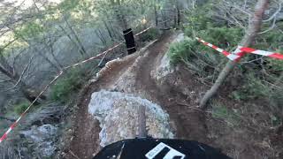
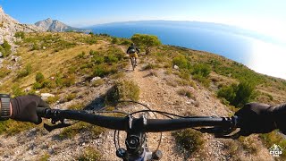
Photos of Split
Videos of Split
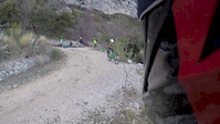
trail: Azbestoza
3:24 |
190 |
Feb 24, 2020
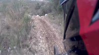
trail: Azbestoza
6:01 |
200 |
Feb 7, 2018
trail: Azbestoza
0:45 |
308 |
Feb 7, 2018
trail: Girometta
2:01 |
439 |
Jan 20, 2013

trail: Bitnica
2:41 |
222 |
Nov 3, 2024 , Split
trail: ONA
3:31 |
287 |
Jan 26, 2023 , Split
trail: Viper b-line
15:03 |
340 |
Nov 29, 2021 , Split

trail: Azbestoza
5:51 |
743 |
Feb 23, 2018 , Split
Recent Trail Reports
| status | trail | date | condition | info | user |
|---|---|---|---|---|---|
| Viper b-line | Apr 29, 2026 @ 10:35pm (Europe/Zagreb) Apr 29, 2026 | Ideal | DanielWy2dJ4 | ||
| Milf | Mar 8, 2026 @ 3:48pm (Europe/Zagreb) Mar 8, 2026 | Ideal | TomaCube | ||
| Azbestoza | Jan 18, 2026 @ 4:04pm (Europe/Zagreb) Jan 18, 2026 | Ideal | Kuki-st | ||
| Viper new bottom part | Oct 7, 2025 @ 11:42am (Europe/Zagreb) Oct 7, 2025 | Very Dry | ckohlmeier | ||
| Voćkina - Južna transfer | Sep 25, 2024 @ 9:29am Sep 25, 2024 | Wet | jeffnelson19784 | ||
| Voćkina | Sep 25, 2024 @ 9:29am Sep 25, 2024 | Wet | jeffnelson19784 | ||
| Đumbirova | Sep 25, 2024 @ 9:29am Sep 25, 2024 | Wet | jeffnelson19784 | ||
| Vrata - Vrh | Apr 8, 2023 @ 7:31am Apr 8, 2023 | Ideal | milanZg | ||
| Sedlo - Vrh | Oct 11, 2022 @ 2:29pm Oct 11, 2022 | Dry | virtujozo | ||
| Do druge vode | Oct 5, 2022 @ 12:53am Oct 5, 2022 | Ideal | Flow-24 |
Activity Feed
| username | action | type | title | date |
|---|---|---|---|---|
| Felixzjd0mG | wishlist | trail | activity #97793897 | Jun 25, 2026 @ 2:36pm 2 days |
| redguy13 | difficultyvote | trail | activity #95190815 | May 21, 2026 @ 11:40am May 21, 2026 |
| DanielWy2dJ4 | add | report | activity #93669397 and 1 more | Apr 29, 2026 @ 1:35pm Apr 29, 2026 |
| DanielWy2dJ4 | vote | trail | activity #93669367 and 1 more | Apr 29, 2026 @ 1:34pm Apr 29, 2026 |
| KerstinwSBVA1 | vote | trail | activity #91543253 | Mar 29, 2026 @ 12:44pm Mar 29, 2026 |
Recent Comments
| username | type | title | comment | date |
|---|---|---|---|---|
| trail | There are a few older dirt jumps on this trail... | Oct 7, 2023 @ 8:36am Oct 7, 2023 | ||
| trail | This trail has some brutal features, i would... | Jul 24, 2022 @ 10:11am Jul 24, 2022 | ||
| trail | It is steep and partly overgrown a bit. I had... | May 28, 2021 @ 12:08pm May 28, 2021 | ||
| trail | Perfect last part of the viper. Don't forget... | May 28, 2021 @ 12:03pm May 28, 2021 | ||
| trail | It's well mentained, has big drops and... | Jan 1, 2019 @ 11:08am Jan 1, 2019 |
Local Badges
-

Epic Hike 50k0 awarded -

Hiking 100k Badge0 awarded -

Epic Hike Climb 2k1 awarded -

Climbing 10k Badge0 awarded -

Big Hike 10k18 awarded
Activity Type Stats
| activitytype | trails | distance | descent | descent distance | total vertical | rating | global rank | state rank | photos | reports | routes | ridelogs |
|---|---|---|---|---|---|---|---|---|---|---|---|---|
| Mountain Bike | 27 | 11 miles | 6,165 ft | 7 miles | 1,932 ft | #1,837 | #12 | 123 | 66 | 1 | 4,780 | |
| E-Bike | 4 | 1 mile | 1,201 ft | 1 mile | 928 ft | 50 | 680 | |||||
| Winter Fat Bike | 1 | #175 | #24 | |||||||||
| Hike | 24 | 9 miles | 3,835 ft | 5 miles | 1,522 ft | #2,447 | #18 | 57 | 366 | |||
| Trail Running | 24 | 9 miles | 3,835 ft | 5 miles | 1,522 ft | #1,976 | #17 | 57 | 426 | |||
| Dirtbike/Moto | 1 | 3 | ||||||||||
| ATV/ORV/OHV | 1 | 3 |
Frequently Asked Questions About Split
▼
What are the best places to hike in Split?
Split has 3 areas to explore for hiking. The top rated areas are:
▼
What are the highest rated hiking trails in Split?
The highest rated hiking trails in Split are:
- Đumbirova (0/5)
- Girometta (0/5)
- Sveti Maksim - West (0/5)
- Voćkina - Južna transfer (0/5)
- Do druge vode (0/5)
▼
What is the best time of the year to hike in Split?
Based on ride log data, the most popular months to hike in Split are:
- October (2 activities)
- November (1 activities)
- September (1 activities)
▼
Where can I park to hike in Split?
Trails
- By brenthillier
 NSMBA TRAILFORKS & contributors
 - Admins: VjekoslavKrsanac
- #10091 - 16,349 views
- split activity log | embed map of Split mountain bike trails | split mountain biking points of interest
Downloading of trail gps tracks in kml & gpx formats is enabled for Split.
You must login to download files.