close
-
Layers w
- Weather Layers
- Pro
- Pro
- Pro
- Pro
- Pro
- Pro
- More Layers
- Pro
- Pro
- Pro
- Pro
-
Upgrade to

3D
Trail Conditions
- Unknown
- Snow Groomed
- Snow Packed
- Snow Covered
- Snow Cover Partial
- Freeze/thaw Cycle
- Icy
- Prevalent Mud
- Wet
- Variable
- Ideal
- Dry
- Very Dry
Trail Flow (Ridden Direction)
Trailforks scans users ridelogs to determine the most popular direction each trail is ridden. A good flowing trail network will have most trails flowing in a single direction according to their intension.
The colour categories are based on what percentage of riders are riding a trail in its intended direction.
The colour categories are based on what percentage of riders are riding a trail in its intended direction.
- > 96%
- > 90%
- > 80%
- > 70%
- > 50%
- < 50%
- bi-directional trail
- no data
Trail Last Ridden
Trailforks scans ridelogs to determine the last time a trail was ridden.
- < 2 days
- < 1 week
- < 2 weeks
- < 1 month
- < 6 months
- > 6 months
Trail Ridden Direction
The intended direction a trail should be ridden.
- Downhill Only
- Downhill Primary
- Both Directions
- Uphill Primary
- Uphill Only
- One Direction
Contribute Details
Colors indicate trail is missing specified detail.
- Description
- Photos
- Description & Photos
- Videos
Trail Popularity ?
Trailforks scans ridelogs to determine which trails are ridden the most in the last 9 months.
Trails are compared with nearby trails in the same city region with a possible 25 colour shades.
Think of this as a heatmap, more rides = more kinetic energy = warmer colors.
- most popular
- popular
- less popular
- not popular
ATV/ORV/OHV Filter
Max Vehicle Width
inches
US Cell Coverage
Legend

Radar Time
Activity Recordings
Trailforks uses anonymized public activity data.
?
Activity Recordings
Trailforks uses anonymized public activity data.
?
Personal Heatmap
▶
Activity Types
all
/
none
▶
Options
2
Date range
month
–
Winter Trails
Warning
A routing network for winter maps does not exist. Selecting trails using the winter trails layer has been disabled.
Missing Trails
Most Popular
Least Popular
Trails are colored based on popularity. The more popular a trail is, the more red. Less popular trails trend towards green.
Jump Magnitude Heatmap
Heatmap of where riders jump on trails. Zoom in to see individual jumps, click circles to view jump details.
BC Backroad Status
![map legend]()
Service Road Atlas is a free to use, community-driven service for viewing and creating reports on the numerous back-country service roads around B.C. and Alberta.

Slope Aspect
Direction the slope faces
Trails Deemphasized
Trails are shown in grey.
Only show trails with no bike usage.
Suggested Layers
Based on selected activity type
Save the current map location and zoom level as your default home location whenever this page is loaded.
Save
No description for Stryn has been added yet!
Login or register to submit one.
This region uses the Uk/Euro style trail grading system.
Activities Click to view
- Mountain Bike
18 trails
- Adaptive Bike
1 trails
- Winter Fat Bike
0 trails
- Hike
16 trails
- Trail Running
16 trails
Region Details
- 2
- 3
- 3
- 1
- 1
Region Status
Open as of Jan 16, 2026Stats
- Avg Trail Rating
- Trails (view details)
- 18
- Trails Mountain Bike
- 18
- Trails E-Bike
- 3
- Trails Adaptive Bike
- 1
- Trails Hike
- 16
- Trails Trail Running
- 16
- Total Distance
- 28 miles
- Total Descent
- 7,703 ft
- Total Vertical
- 4,746 ft
- Highest Trailhead
- 4,789 ft
- Reports
- 17
- Photos
- 28
- Ridden Counter
- 327
Sub Regions
-
Geiranger
- 1
Popular Stryn Mountain Biking Trails
• 95 ★ 4.0 • 2 miles • 99 ft • 63 •
Machine build trail from start to the bridge. Singeltrack from the bridge to the finish. Park at the parking area, bike a bit up the road, by the sign the trail starts down into the forrest.
• 100 ★ 0.0 • 1,152 ft • 0 ft • 49 •
Popular green difficulty singletrack. This mountain bike primary trail can be used both directions. On average it takes 3 minutes to complete this trail.
• 100 ★ 0.0 • 3 miles • 1,446 ft • 35 •
Popular green difficulty asphalt/tarmac road. This mountain bike primary trail and has a moderate overall physical rating with a 1,446 ft green climb. Trail visibility is always easy to follow. On average it takes 31 minutes to complete this trail.
• 5 ★ 5.0 • 2 miles • 448 ft • 20 •
A fantastic scenic route! But be aware that there are several no fall zones! There is some areas where the bike needs to be pushed or carried. DO NOT BIKE IF RAIN OR IF IT HAS BEEN RAINING!!!
• 90 ★ 5.0 • 2 miles • 277 ft • 19 •
Easy climbing on fireroad. On top starts a nice singletrack. After a while on the trail you have to ride over a log with a jump on. From there the trail goes down to the road. Instead of riding through the tunnel, you cycle on the old...
• 5 ★ 4.5 • 4 miles • 1,547 ft • 17 •
Erdalen, has been updated with new gravel road from the parking and a bit up. Follow the trail all the way to the end of the wolf trail. From there you'll head back the same way to biked up.
• 5 ★ 0.0 • 3,616 ft • 13 ft • 14 •
Easy flow trail which do take long to lap. Wide with some natural jump if you choose. Remember to share the trial with local hikers. Follow the road back to start for another run.
• 5 ★ 4.0 • 1 mile • 34 ft • 9 •
Start 1 for Himalaya trail. A mostly flat trail that follows the river after you cross the bridge, with some boulders that will keep the speed down. There is also a few no fall zones(!) by the river.
Stryn Mountain Bike Routes
13 miles • 6,574 ft • 0 •
Geiranger - Dalsnibba 21 km The route starts at the world famous Geiranger fjord in the small village...
4 miles • 1,513 ft • 0 •
A great eBIKE tour from town up the impressive Eagles road (Orneveien) to the top hairpin corner and...
Photos of Stryn Mountain Bike
Videos of Stryn Mountain Bike
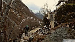
trail: Napen
14:34 |
379 |
Nov 25, 2021 , Stryn
Recent Trail Reports
| status | trail | date | condition | info | user |
|---|---|---|---|---|---|
| Napen | Sep 9, 2025 @ 2:26am Sep 9, 2025 | Ideal | SirRanzelot | ||
| Djupvatten to Mt. Dalsnibba | Jun 27, 2024 @ 2:13am Jun 27, 2024 | Very Dry | turbotobbe | ||
| Vinsrygg Enduro | Aug 8, 2022 @ 10:11am Aug 8, 2022 | Variable | Jarsetim | ||
| Himalayastien (Glæra) | Jul 29, 2019 @ 9:03am Jul 29, 2019 | Dry | FolvenAS | ||
| Skåråsen | Jul 15, 2018 @ 3:12pm Jul 15, 2018 | Dry | Garliden |
Activity Feed
| username | action | type | title | date |
|---|---|---|---|---|
| IrmantasGint | ridden | trail | activity #98808092 | Jul 9, 2026 @ 1:11pm 2 days |
| IrmantasGint | wishlist | trail | activity #98808069 | Jul 9, 2026 @ 1:10pm 2 days |
| Maxb77f05 | ridden | trail | activity #98405472 | Jul 4, 2026 @ 5:39am Jul 4, 2026 |
| Awkb3f | wishlist | trail | activity #94182517 | May 6, 2026 @ 4:01pm May 6, 2026 |
| Cykeljohan | add | trail | activity #92239398 and 1 more | Apr 9, 2026 @ 1:22am Apr 9, 2026 |
Recent Comments
| username | type | title | comment | date |
|---|---|---|---|---|
| trail | Wow, really amazed by this trail. First it... | Aug 13, 2023 @ 6:58am Aug 13, 2023 | ||
| trail | Did it today after some 100 meter is some... | Jun 24, 2022 @ 2:24pm Jun 24, 2022 | ||
| trail | Had a fun time riding this trail, including... | Aug 16, 2019 @ 3:47am Aug 16, 2019 | ||
| trail | Best Trail ever! Thank you very much, Boys and... | Jul 28, 2017 @ 6:50am Jul 28, 2017 |
Local Badges
-

Epic Ride Climb 2k19 awarded -

Climbing 10k Badge3 awarded -

Climbing 100k Badge0 awarded -

Epic Ride Descent 2k19 awarded -

Descent 10k Badge4 awarded -

Descent 100k Badge0 awarded
Bike & Skill Parks
| name | type | city | rating |
|---|---|---|---|
| Folven Pumptrack | skill park | Stryn |
Activity Type Stats
| activitytype | trails | distance | descent | descent distance | total vertical | rating | global rank | state rank | photos | reports | routes | ridelogs |
|---|---|---|---|---|---|---|---|---|---|---|---|---|
| Mountain Bike | 18 | 28 miles | 7,703 ft | 12 miles | 4,747 ft | #1,673 | #21 | 27 | 17 | 2 | 1,432 | |
| E-Bike | 3 | 6 miles | 436 ft | 4,255 ft | 4,747 ft | 1 | 11 | 99 | ||||
| Adaptive Bike | 1 | #147 | #26 | |||||||||
| Hike | 16 | 23 miles | 6,129 ft | 9 miles | 4,695 ft | #1,904 | #29 | 15 | 1,206 | |||
| Trail Running | 16 | 23 miles | 6,129 ft | 9 miles | 4,695 ft | #1,437 | #28 | 15 | 4 |
Frequently Asked Questions About Stryn
▼
What are the best places to ride in Stryn?
Stryn has 2 areas to explore for mountain biking. The top rated areas are:
▼
What are the highest rated mountain biking trails in Stryn?
The highest rated mountain biking trails in Stryn are:
- Himalayastien (Glæra) (4.3/5)
- Skåråsen (4.2/5)
- Sunndalssætra Part 3 (4.1/5)
- Sunndalssætra Part 1 (4.1/5)
- Himalayastien, Easy start (4.1/5)
▼
What is the best time of the year to ride in Stryn?
Based on ride log data, the most popular months to ride in Stryn are:
- July (43 activities)
- August (13 activities)
- June (9 activities)
▼
Where can I park to ride in Stryn?
There are 1 parking locations listed in Stryn. The most popular parking spots are:
Trails
- By jhpf & contributors
- Admins: Fausken77, diegostrangerm
- #14697 - 10,804 views
- stryn activity log | embed map of Stryn mountain bike trails | stryn mountain biking points of interest
Downloading of trail gps tracks in kml & gpx formats is enabled for Stryn.
You must login to download files.