


more stats
2.0 miles
Distance
99 ft
Climb
-877 ft
Descent
00:24:39
Avg time
-779 ft
Altitude change
394 ft
Altitude min
1,172 ft
Altitude max
1,172 ft
Altitude start
394 ft
Altitude end
-7.5%
Grade
-60.4%
Grade max
20.5%
Grade min
1,115 ft
Distance climb
1 mile
Distance down
1,598 ft
Distance flat
00:24:39
Avg time

Napen Details

  • Activities
    • Mountain Bike
  • Riding Area
  • Difficulty Rating
  • Voted Difficulty
    Red (1 vote)
  • Local Popularity
    75 in Mountain Biking
  • Global Ranking
    #72442 in Mountain Biking
  • National Ranking
    #464 in Mountain Biking · Norway
  • Trail Type
    Machine Groomed
  • Bike Type
    DH, AM
  • Direction
    Downhill Primary
    Popular Direction Shown
  • Physical Rating
    Moderate
  • Trail Visibility
    Always easy to follow
  • Alpine Trail
    Yes
  • Dogs Allowed
    Yes
  • TTFs on Trail
    A-Frame, Berm, Bridge, Jump, Rock Face, Rock Garden

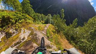
Machine build trail from start to the bridge. Singeltrack from the bridge to the finish.

Park at the parking area, bike a bit up the road, by the sign the trail starts down into the forrest.

Recent Activity on Trail

Past Week
  • 0 rides
  •  
6 Months
  • 1 rides
  • 8 miles avg distance
All
  • 27 rides
  • Last: Jul 19, 2026
update trails status or condition

Napen Trail Reports

statusdatedescription
Sep 9, 2025 @ 2:26am
Sep 9, 2025
Rode it on 31st of August: all clear. Some lower parts slightly overgrown and minor need for re-shape on some take-offs. In general very good...
Jul 27, 2024 @ 2:59am
Jul 27, 2024
Awesome ride! Struggling sometimes with the hardtail but managed and had good fun
Jul 27, 2024 @ 2:59am
Jul 27, 2024
Awesome ride! Struggling sometimes with the hardtail but managed and had good fun
Aug 13, 2023 @ 3:10pm
Aug 13, 2023
WOW!!! And WOW!!! Haven't had that much fun in a very long time A fantastic trail. And looong. I just love it! A little bit wet in the lower part...
Oct 11, 2017 @ 3:00am
Oct 11, 2017
New machine section added. Old trail info is wrong. The new track is hand and machine made all the way from topp to the bridge. Single track...
more »
Status:
on Sep 9, 2025
Ideal
Avg: 3.99 (5 votes)
Your vote: 0

view (126)
close
      Directions to napen trailhead (61.936920, 7.260150)

      Photos

      5 more »
      mtb
      90 |
      Jul 15, 2024 @ 12:05am
      Jul 15, 2024
      report
      mtb
      70 |
      Aug 13, 2023 @ 3:10pm
      Aug 13, 2023
      report
      mtb
      71 |
      Aug 13, 2023 @ 3:10pm
      Aug 13, 2023
      report
      mtb
      73 |
      Aug 13, 2023 @ 3:10pm
      Aug 13, 2023

      Videos

      2 more »
      Stryn - Napen - MTB POV
      mtb
      8:28 | 18 | Sep 12, 2026 , Stryn
      NAPEN BIKE TRAIL - STRYNEFJELLET
      mtb
      14:34 | 405 | Nov 25, 2021 , Stryn
      4.2 ★★★★★
      5 Ratings
      5 ★ 80%
      4 ★
      3 ★
      2 ★
      1 ★ 20%

      3 Reviews & Comments

      SimonW2h0WN
      Wow, really amazed by this trail. First it starts with a few jumps where one feels very confident. Pretty well built. Then you go into like a downhill passage. There you hit some features and roll over stones. That passage was extremely funny. At last you ride over a tiny bridge and stand next to a waterfall. Totally beautiful.
      Thanks to the builder and the ones who care about the trail. It made my Norway trip even better.
      Stisyklaren
      Had a fun time riding this trail, including the jumps at the start. Many thanks for making this trail!
      LemoManda LemoManda
      Best Trail ever! Thank you very much, Boys and Girls who build it ???? I would prefer a Fully to my Hardtail, but it's still possible to Ride ????

      We hope you've been enjoying Trailforks!

      Create a FREE account to view all trail reviews and much more.

      • By jhpf & contributors
      • #59812 - 4,700 views

      Frequently Asked Questions

      ▼ Where is Napen located?
      Napen is located in Stryn, Norway. It is part of the Stryn trail network. The trailhead is located at coordinates 61.93692, 7.26015.
      ▼ How hard is Napen?
      Napen is rated as Black Diamond difficulty. The physical rating is Moderate. The average grade is 7.5%.
      ▼ What is the elevation gain for Napen?
      Napen has 99 ft of elevation gain. The trail has 877 ft of elevation descent. The elevation ranges from 394 ft to 1,172 ft.
      ▼ Is Napen a point to point trail?
      Napen is not a point to point trail. The direction is Downhill Primary. The trail type is machine groomed.
      ▼ How long is Napen?
      Napen is 2.0 miles long. The trail type is machine groomed.
      ▼ Are dogs allowed on Napen?
      Yes, dogs are allowed on Napen. Please keep dogs on a leash where required and clean up after them.
      ▼ How do I access Napen? Where is the closest parking trailhead?
      The closest parking and trailhead locations to Napen are: View all parking locations in the area.
      ▼ How long does it take to ride Napen?
      Based on recorded activities, it takes an average of 25 minutes to ride Napen. The trail is 2.0 miles long. Actual times will vary based on fitness level, conditions, and pace. View recent activity logs for more details.
      ▼ How busy is Napen?
      Napen is a very popular trail. There have been 101 recorded activities on this trail. The trail has received 126 check-ins. View recent activity on this trail.

      Hit the Trail

      Open in App

      Get this trail on your phone instantly.

      open trail in app

      Download Trail

      Save to wishlist, Garmin & download.
      save the trail

      Find Related Routes

      Find routes and users activities that include this trail.
      find routes for this trail

      You must enter a description before submitting.

