close
-
Layers w
- Weather Layers
- Pro
- Pro
- Pro
- Pro
- Pro
- Pro
- More Layers
- Pro
- Pro
- Pro
- Pro
-
Upgrade to

3D
Trail Conditions
- Unknown
- Snow Groomed
- Snow Packed
- Snow Covered
- Snow Cover Partial
- Freeze/thaw Cycle
- Icy
- Prevalent Mud
- Wet
- Variable
- Ideal
- Dry
- Very Dry
Trail Flow (Ridden Direction)
Trailforks scans users ridelogs to determine the most popular direction each trail is ridden. A good flowing trail network will have most trails flowing in a single direction according to their intension.
The colour categories are based on what percentage of riders are riding a trail in its intended direction.
The colour categories are based on what percentage of riders are riding a trail in its intended direction.
- > 96%
- > 90%
- > 80%
- > 70%
- > 50%
- < 50%
- bi-directional trail
- no data
Trail Last Ridden
Trailforks scans ridelogs to determine the last time a trail was ridden.
- < 2 days
- < 1 week
- < 2 weeks
- < 1 month
- < 6 months
- > 6 months
Trail Ridden Direction
The intended direction a trail should be ridden.
- Downhill Only
- Downhill Primary
- Both Directions
- Uphill Primary
- Uphill Only
- One Direction
Contribute Details
Colors indicate trail is missing specified detail.
- Description
- Photos
- Description & Photos
- Videos
Trail Popularity ?
Trailforks scans ridelogs to determine which trails are ridden the most in the last 9 months.
Trails are compared with nearby trails in the same city region with a possible 25 colour shades.
Think of this as a heatmap, more rides = more kinetic energy = warmer colors.
- most popular
- popular
- less popular
- not popular
ATV/ORV/OHV Filter
Max Vehicle Width
inches
US Cell Coverage
Legend

Radar Time
Activity Recordings
Trailforks uses anonymized public activity data.
?
Activity Recordings
Trailforks uses anonymized public activity data.
?
Personal Heatmap
▶
Activity Types
all
/
none
▶
Options
2
Date range
month
–
Winter Trails
Warning
A routing network for winter maps does not exist. Selecting trails using the winter trails layer has been disabled.
Missing Trails
Most Popular
Least Popular
Trails are colored based on popularity. The more popular a trail is, the more red. Less popular trails trend towards green.
Jump Magnitude Heatmap
Heatmap of where riders jump on trails. Zoom in to see individual jumps, click circles to view jump details.
BC Backroad Status
![map legend]()
Service Road Atlas is a free to use, community-driven service for viewing and creating reports on the numerous back-country service roads around B.C. and Alberta.

Slope Aspect
Direction the slope faces
Trails Deemphasized
Trails are shown in grey.
Only show trails with no bike usage.
Suggested Layers
Based on selected activity type
Save the current map location and zoom level as your default home location whenever this page is loaded.
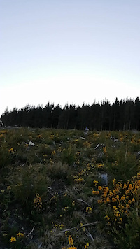
SaveTicknock offers up to 30 km of mountain and forest walks with some spectacular views of Dublin City, Dublin Bay, Bray Head and Wicklow Mountains. The forest has an extensive network of forest trails with pleasant moderate walks through the trees, it also has a tarmac road leading all the way to the top and is easily accessible for children and people with lower level of fitness.
Walk: Walking trails in this forest include Fairy Castle Loop, Dublin Mountains Way and Wicklow Way; The Fairy Castle loop (5.5 kms, 1 ½ hrs, moderate) is a lovely looped walk taking in the wonderful views over Dublin from Three Rock Mountain and Fairy Castle, traversing sections of the Dublin Mountains Way and Wicklow Way, before returning via the old rifle range to the car park.
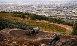
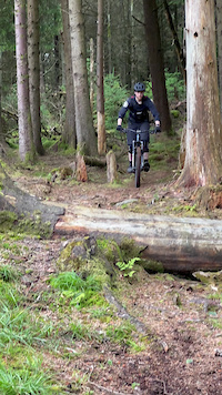
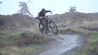
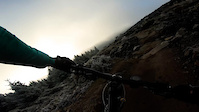
Mountain Biking: Ticknock Mountain Bike Trail is a network of purpose-built singletrack trails and forest roads that are designated for use by mountain bikes on a waymarked circular route of 8km in length. The trails take the rider through beautiful forest and heathland with fantastic views over Dublin City and Bay and the Wicklow Mountains beyond. Forest road climbs lead you into tight twisty singletrack with loads of fast descents, ups and downs, tight turns and technical rocky bits, guaranteed to leave you smiling The trails are waymarked in one direction, please follow the red arrows.
Permanent Orienteering: Tiknock has 2 permanent orienteering courses, Short (1.1 km) and Medium (2.6 km).
There are three large rock formations (Three Rock Mountain) just after the end of the tarmac road great to climb on and sit and enjoy the picturesque views over the Wicklow mountains and the coast. Further up in the area, there is also a Two Rock Mountain (536 meters above the sea level) with romantic ruins of the Fairy Castle.
Walk: Walking trails in this forest include Fairy Castle Loop, Dublin Mountains Way and Wicklow Way; The Fairy Castle loop (5.5 kms, 1 ½ hrs, moderate) is a lovely looped walk taking in the wonderful views over Dublin from Three Rock Mountain and Fairy Castle, traversing sections of the Dublin Mountains Way and Wicklow Way, before returning via the old rifle range to the car park.
Mountain Biking: Ticknock Mountain Bike Trail is a network of purpose-built singletrack trails and forest roads that are designated for use by mountain bikes on a waymarked circular route of 8km in length. The trails take the rider through beautiful forest and heathland with fantastic views over Dublin City and Bay and the Wicklow Mountains beyond. Forest road climbs lead you into tight twisty singletrack with loads of fast descents, ups and downs, tight turns and technical rocky bits, guaranteed to leave you smiling The trails are waymarked in one direction, please follow the red arrows.
Permanent Orienteering: Tiknock has 2 permanent orienteering courses, Short (1.1 km) and Medium (2.6 km).
There are three large rock formations (Three Rock Mountain) just after the end of the tarmac road great to climb on and sit and enjoy the picturesque views over the Wicklow mountains and the coast. Further up in the area, there is also a Two Rock Mountain (536 meters above the sea level) with romantic ruins of the Fairy Castle.
Primary Trail Type: Cross-Country
eBikes Allowed:
Yes
AKA: Three Rock
Land Status: Community Forest
 google parking directions
 Access Info:
Lower OR Upper Car Park. You can also park next to Blue Light pub on the other side of the mountain.
Links
This region uses the Uk/Euro style trail grading system.
Activities Click to view
- Mountain Bike
167 trails
- E-Bike
169 trails
- Hike
78 trails
- Trail Running
80 trails
Region Details
- 13
- 17
- 14
- 31
Region Status
Open as of Jun 2, 2026Stats
- Avg Trail Rating
- Trails (view details)
- 100
- Trails Mountain Bike
- 172
- Trails E-Bike
- 169
- Trails Hike
- 78
- Trails Trail Running
- 80
- Total Distance
- 30 miles
- Total Descent
- 11,077 ft
- Total Vertical
- 1,205 ft
- Highest Trailhead
- 1,783 ft
- Reports
- 3,846
- Photos
- 168
- Ridden Counter
- 29,830
Articles
Video: Behind the Scenes of Building Greg Callaghan's Dream Trail
Mar 19, 2025 from pinkbike.com
Part 1 of a 3-part series documenting the whole process, from designing, building, and testing all the way up to opening the trail.
Popular Ticknock Mountain Biking Trails
• 100 ★ 4.4 • 1,119 ft • 0 ft • 900 •
The best well known and flowy trail around. Transformed some couple years ago from a tech trail with the adage of big berms and smooth flowing lines and extended all the way down to the Biking.ie hut. The surface is firm and...
• 100 ★ 5.0 • 577 ft • 0 ft • 765 •
Highly rated popular red difficulty singletrack. This mountain bike primary trail can be used downhill primary and has a moderate overall physical rating. It features rock face. On average it takes minutes to complete this trail.
• 100 ★ 4.3 • 1 mile • 243 ft • 756 •
Part of the Ticknock trail center oficial trail is broadly used by most of riders to start their ride in the area. It connects to several natural trails. The descent section is fast and fun with some small rockgardens and features.
• 100 ★ 4.5 • 1,312 ft • 0 ft • 699 •
last section of Ticknock MTB trail that leaves you right next to the cafe and bike wash area
• 95 ★ 4.4 • 4,948 ft • 201 ft • 658 •
Second section of the official trail center trail. Climb only trail with no major obstacles or difficulties. Is not a shared trail but you may find hikers on it, be respectful even if you have priority.
• 90 ★ 4.5 • 4,452 ft • 45 ft • 646 •
Bike only trail part of the official trail center marked trails in Ticknock. Recently revamped is fun and fast. No big obstacles, good trail for novice-mid level riders. Can be done on gravel bike and if you are a masochist, also on CX
• 95 ★ 4.5 • 1,306 ft • 16 ft • 606 •
Popular red difficulty machine groomed. This mountain bike primary trail can be used downhill only and has a moderate overall physical rating with a 16 ft black diamond climb. It features berm and jump. Trail visibility is always easy to follow. On average it takes 1 minutes to complete this trail.
• 100 ★ 4.0 • 443 ft • 7 ft • 600 •
short fast last section of , be aware when crossing the tarmac road, bikes have preference but better watch out
Ticknock Mountain Bike Routes
10 miles • 2,089 ft • 5 • Loop •
Wednesday Nighttime spin for winter training and a social pint afterwards in Blue Light!
48 miles • 7,315 ft • 6 •
Loop from Mount Venus/Cruagh via Wicklow Way to Ballinastoe
51 miles • 7,431 ft • 0 •
Photos of Ticknock Mountain Bike
Videos of Ticknock Mountain Bike
trail: Silliest Simon
0:10 |
95 |
Jul 19, 2024
trail: Silliest Simon
0:08 |
67 |
Jul 12, 2024
trail: Silliest Simon
0:08 |
71 |
Jun 21, 2024
trail: Leap of the Bunny
0:10 |
196 |
Apr 23, 2021
trail: Pumptrack
2:49 |
280 |
Mar 27, 2021

trail: After Burner (upper)
0:02 |
146 |
Jan 22, 2021

0:00 |
60 |
Jan 22, 2021
trail: After Burner (upper)
0:16 |
163 |
Dec 4, 2020
Current Trail Warnings
| status | trail | date | condition | user | info |
|---|---|---|---|---|---|
| Blaze | Jun 2, 2026 @ 3:06pm (Europe/Dublin) Jun 2, 2026 | Unknown | menukunz Thun Kandertal | closed? | |
| Silliest Simon | Jun 2, 2026 @ 3:05pm (Europe/Dublin) Jun 2, 2026 | Unknown | menukunz Thun Kandertal | closed? |
Recent Trail Reports
| status | trail | date | condition | info | user |
|---|---|---|---|---|---|
| Husqy | Jun 2, 2026 @ 11:58am (Europe/Dublin) Jun 2, 2026 | Unknown | menukunz Thun Kandertal | ||
| Blazin' Saddles | Jun 2, 2026 @ 11:30am (Europe/Dublin) Jun 2, 2026 | Unknown | menukunz Thun Kandertal | ||
| Highline | May 29, 2026 @ 2:18pm (Europe/Dublin) May 29, 2026 | Ideal | harryquinn3 | ||
| Que Pasa | May 29, 2026 @ 2:18pm (Europe/Dublin) May 29, 2026 | Dry | harryquinn3 | ||
| High Line high section | May 29, 2026 @ 2:18pm (Europe/Dublin) May 29, 2026 | Dry | harryquinn3 | ||
| Skyline | May 29, 2026 @ 2:18pm (Europe/Dublin) May 29, 2026 | Dry | harryquinn3 | ||
| Skyline | May 29, 2026 @ 2:18pm (Europe/Dublin) May 29, 2026 | Dry | harryquinn3 | ||
| Tir na Shouge | May 29, 2026 @ 2:18pm (Europe/Dublin) May 29, 2026 | Dry | harryquinn3 | ||
| Tomahawk | May 29, 2026 @ 2:18pm (Europe/Dublin) May 29, 2026 | Dry | harryquinn3 | ||
| Top Area Connector 2 | May 3, 2026 @ 10:09pm (Europe/Dublin) May 3, 2026 | Ideal | elyari TRAILFORKS |
Activity Feed
| username | action | type | title | date |
|---|---|---|---|---|
| BrendonSmythb0w | wishlist | region | activity #96368749 | Jun 6, 2026 @ 7:33am Jun 6, 2026 |
| menukunz | add | photo | activity #96286322 | Jun 5, 2026 @ 4:40am Jun 5, 2026 |
| martyire | comment | report | activity #96113428 | Jun 2, 2026 @ 3:30pm Jun 2, 2026 |
| menukunz | add | photo | activity #96081477 | Jun 2, 2026 @ 7:06am Jun 2, 2026 |
| menukunz | add | report | activity #96081435 and 1 more | Jun 2, 2026 @ 7:05am Jun 2, 2026 |
Recent Comments
| username | type | title | comment | date |
|---|---|---|---|---|
| report | yup pretty sure they are gone quite a while. | Jun 2, 2026 @ 3:30pm Jun 2, 2026 | ||
| trail | The climb is a piece of work, 10/10 would... | Jan 1, 2026 @ 11:56am Jan 1, 2026 | ||
| trail | Completed on non-suspension Gravel Bike. 38c... | Jul 15, 2024 @ 1:20am Jul 15, 2024 | ||
| trail | Completed on non-suspension gravel bike. 38c... | Jul 15, 2024 @ 1:10am Jul 15, 2024 | ||
| trail | Completed on non-suspension gravel bike. 38c... | Jul 15, 2024 @ 1:07am Jul 15, 2024 |
Nearby Areas
| name | distance | ||||
|---|---|---|---|---|---|
| Stepaside village | 1 | 1.2 km | |||
| Tibradden Woods | 4 | 13 | 1.6 km | ||
| The GAP | 4 | 6 | 1.7 km | ||
| Cruagh Woods | 3 | 12 | 7 | 2.5 km | |
| Barnaslingan Wood | 2 | 1 | 3.6 km |
Local Badges
-

Completionist0 awarded
Activity Type Stats
| activitytype | trails | distance | descent | descent distance | total vertical | rating | global rank | state rank | photos | reports | routes | ridelogs |
|---|---|---|---|---|---|---|---|---|---|---|---|---|
| Mountain Bike | 167 | 28 miles | 10,797 ft | 18 miles | 1,204 ft | #147 | #1 | 168 | 3,845 | 7 | 25,914 | |
| E-Bike | 169 | 28 miles | 10,797 ft | 18 miles | 1,204 ft | #319 | #6 | 3,516 | 1 | 3,427 | ||
| Hike | 78 | 16 miles | 4,603 ft | 9 miles | 1,168 ft | #1,273 | #7 | 3,644 | 426 | |||
| Trail Running | 80 | 17 miles | 4,882 ft | 9 miles | 1,168 ft | #706 | #7 | 3,650 | 644 |
Frequently Asked Questions About Ticknock
▼
What are the highest rated mountain biking trails in Ticknock?
The highest rated mountain biking trails in Ticknock are:
- Pumptrack (4.5/5)
- After Burner lower (after rebuild) (4.4/5)
- Skyline (4.3/5)
- Blazin' Saddles (4.3/5)
- Boneshaker (4.3/5)
▼
What is the best time of the year to ride in Ticknock?
Based on ride log data, the most popular months to ride in Ticknock are:
- February (164 activities)
- November (154 activities)
- June (153 activities)
▼
Where can I park to ride in Ticknock?
There are 2 parking locations listed in Ticknock. The most popular parking spots are:
▼
What is the longest trail in Ticknock?
The longest trail in Ticknock is Devils Elbow at 2.3 km. View all trails sorted by distance.
Activities
Trails
Points of Interest
- By motrocks & contributors
- Admins: apply
- #10707 - 45,749 views
- ticknock activity log | embed map of Ticknock mountain bike trails | ticknock mountain biking points of interest
Downloading of trail gps tracks in kml & gpx formats is enabled for Ticknock.
You must login to download files.