close
-
Layers w
- Weather Layers
- Pro
- Pro
- Pro
- Pro
- Pro
- Pro
- More Layers
- Pro
- Pro
- Pro
- Pro
-
Upgrade to

3D
Trail Conditions
- Unknown
- Snow Groomed
- Snow Packed
- Snow Covered
- Snow Cover Partial
- Freeze/thaw Cycle
- Icy
- Prevalent Mud
- Wet
- Variable
- Ideal
- Dry
- Very Dry
Trail Flow (Ridden Direction)
Trailforks scans users ridelogs to determine the most popular direction each trail is ridden. A good flowing trail network will have most trails flowing in a single direction according to their intension.
The colour categories are based on what percentage of riders are riding a trail in its intended direction.
The colour categories are based on what percentage of riders are riding a trail in its intended direction.
- > 96%
- > 90%
- > 80%
- > 70%
- > 50%
- < 50%
- bi-directional trail
- no data
Trail Last Ridden
Trailforks scans ridelogs to determine the last time a trail was ridden.
- < 2 days
- < 1 week
- < 2 weeks
- < 1 month
- < 6 months
- > 6 months
Trail Ridden Direction
The intended direction a trail should be ridden.
- Downhill Only
- Downhill Primary
- Both Directions
- Uphill Primary
- Uphill Only
- One Direction
Contribute Details
Colors indicate trail is missing specified detail.
- Description
- Photos
- Description & Photos
- Videos
Trail Popularity ?
Trailforks scans ridelogs to determine which trails are ridden the most in the last 9 months.
Trails are compared with nearby trails in the same city region with a possible 25 colour shades.
Think of this as a heatmap, more rides = more kinetic energy = warmer colors.
- most popular
- popular
- less popular
- not popular
ATV/ORV/OHV Filter
Max Vehicle Width
inches
US Cell Coverage
Legend

Radar Time
Activity Recordings
Trailforks uses anonymized public activity data.
?
Activity Recordings
Trailforks uses anonymized public activity data.
?
Personal Heatmap
▶
Activity Types
all
/
none
▶
Options
2
Date range
month
–
Winter Trails
Warning
A routing network for winter maps does not exist. Selecting trails using the winter trails layer has been disabled.
Missing Trails
Most Popular
Least Popular
Trails are colored based on popularity. The more popular a trail is, the more red. Less popular trails trend towards green.
Jump Magnitude Heatmap
Heatmap of where riders jump on trails. Zoom in to see individual jumps, click circles to view jump details.
BC Backroad Status
![map legend]()
Service Road Atlas is a free to use, community-driven service for viewing and creating reports on the numerous back-country service roads around B.C. and Alberta.

Slope Aspect
Direction the slope faces
Trails Deemphasized
Trails are shown in grey.
Only show trails with no bike usage.
Suggested Layers
Based on selected activity type
Save the current map location and zoom level as your default home location whenever this page is loaded.
Save
No description for Tofte has been added yet!
Login or register to submit one.
Activities Click to view
- Mountain Bike
12 trails
- Winter Fat Bike
0 trails
- Horse
1 trails
- Hike
52 trails
- Trail Running
52 trails
- Snowshoe
22 trails
- Nordic Ski
24 trails
Region Details
- 2
- 3
- 5
- 2
Region Status
Caution as of Oct 30, 2025Stats
- Avg Trail Rating
- Trails (view details)
- 53
- Trails Mountain Bike
- 12
- Trails E-Bike
- 1
- Trails Horse
- 1
- Trails Hike
- 52
- Trails Trail Running
- 52
- Trails Snowshoe
- 22
- Trails Nordic Ski
- 24
- Total Distance
- 94 miles
- Total Descent
- 8,781 ft
- Total Vertical
- 1,250 ft
- Highest Trailhead
- 1,859 ft
- Reports
- 157
- Photos
- 126
- Ridden Counter
- 3,532
Sub Regions
-
Britton Peak
- 2
- 3
- 1
Popular Tofte Mountain Biking Trails
• 100 ★ 4.9 • 9 miles • 1,154 ft • 698 •
connects Britton Peak, near Tofte, to the Onion River Road. connects the Onion River Road to Lutsen Mountains. Together these trails form a long wilderness segment, offering a one-of-a-kind riding experience for users as it flows over...
• 75 ★ 4.6 • 5 miles • 717 ft • 445 •
runs from Skihill Rd at Lutsen to the Onion River road. the trail continues as trial on the other side of Onion River road, for a total distance between trailheads of about 15 miles. This side is slightly easier than the side: the rock...
• 65 ★ 4.0 • 1 mile • 53 ft • 170 •
Great gnarly trails, nice rock gardens bridges and flow!
• 40 ★ 3.8 • 2 miles • 158 ft • 156 •
A 1.3 miles intermediate level trail of flowy single track. Easy in technical skill, yet will test your fitness. Variety of trail features including unique boardwalks, long climbs and descents, and fun rock features.
• 85 ★ 5.0 • 1 mile • 76 ft • 48 •
Popular green difficulty singletrack. This mountain bike primary trail can be used one direction and has a easy overall physical rating with a 76 ft green climb.
• ★ 0.0 • 571 ft • 6 ft • 5 •
Blue difficulty singletrack. This mountain bike primary trail can be used both directions and has a moderate overall physical rating with a 6 ft blue climb. It features berm, bridge and roller coaster.
Photos of Tofte Mountain Bike
Videos of Tofte Mountain Bike
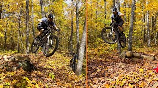
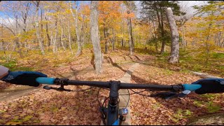
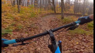
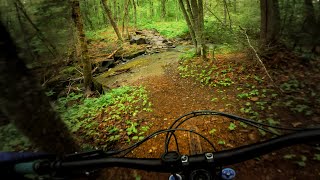
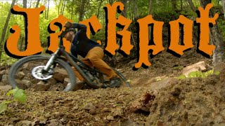
trail: Jackpot
21:55 |
131 |
Sep 26, 2024 , Tofte
trail: Jackpot
26:07 |
282 |
Mar 23, 2024 , Tofte
trail: Jackpot
18:45 |
200 |
Oct 20, 2023 , Tofte
trail: Jackpot
20:40 |
134 |
Oct 14, 2023 , Tofte
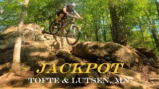
youtuber
![The BEST flow trail in Minnesota? || Jackpot...]()
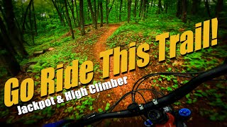
trail: High Climber
16:23 |
939 |
Jul 4, 2022 , Tofte
youtuber
![I might have hit the Jackpot! || High Climber...]()
trail: High Climber
17:31 |
363 |
Jun 27, 2022 , Tofte
trail: High Climber
18:40 |
590 |
Jun 10, 2021 , Tofte
Recent Trail Reports
| status | trail | date | condition | info | user |
|---|---|---|---|---|---|
| High Climber | Oct 30, 2025 @ 11:59am (America/Chicago) Oct 30, 2025 | Ideal | dirtcandy | ||
| Jackpot | Oct 1, 2025 @ 12:46pm (America/Chicago) Oct 1, 2025 | Unknown | GuyThompson IROC | ||
| Short Stacker Access | Jun 9, 2024 @ 1:31am Jun 9, 2024 | Ideal | dirtcandy | ||
| Flume | Jun 9, 2024 @ 1:31am Jun 9, 2024 | Variable | dirtcandy | ||
| Skookum Trail | Jun 9, 2024 @ 1:31am Jun 9, 2024 | Variable | dirtcandy | ||
| Crosscut | Jun 9, 2024 @ 1:31am Jun 9, 2024 | Variable | dirtcandy |
Activity Feed
| username | action | type | title | date |
|---|---|---|---|---|
| ShaneMDgfDr | add | event | activity #94109670 | May 5, 2026 @ 12:47pm May 5, 2026 |
| ShaneMDgfDr | add | event | activity #92739667 | Apr 16, 2026 @ 11:47am Apr 16, 2026 |
| ShaneMDgfDr | add | event | activity #92598795 | Apr 14, 2026 @ 8:24am Apr 14, 2026 |
| 2Quiet | wishlist | trail | activity #88186828 | Feb 1, 2026 @ 2:03pm Feb 1, 2026 |
| matux | wishlist | trail | activity #86250314 | Dec 28, 2025 @ 5:43pm Dec 28, 2025 |
Recent Comments
| username | type | title | comment | date |
|---|---|---|---|---|
| trail | High Climber is in stellar condition right... | Oct 11, 2025 @ 5:18pm Oct 11, 2025 | ||
| trail | This is such a great trail. The amount of... | Aug 21, 2025 @ 1:57pm Aug 21, 2025 | ||
| trail | Tree down on Jackpot 4.2 miles from Tofte lot.... | Jun 25, 2025 @ 1:17pm Jun 25, 2025 | ||
| trail | Great features to work on skills!! | Jun 14, 2025 @ 6:29pm Jun 14, 2025 | ||
| trail | Just a nice little easy start/connector and... | Jun 13, 2025 @ 10:21am Jun 13, 2025 |
Local Badges
-

Epic Ride Climb 2k4 awarded -

Climbing 10k Badge1 awarded -

Climbing 100k Badge0 awarded -

Epic Ride Descent 2k4 awarded -

Descent 10k Badge1 awarded -

Descent 100k Badge0 awarded
Activity Type Stats
| activitytype | trails | distance | descent | descent distance | total vertical | rating | global rank | state rank | photos | reports | routes | ridelogs |
|---|---|---|---|---|---|---|---|---|---|---|---|---|
| Mountain Bike | 12 | 31 miles | 2,608 ft | 13 miles | 978 ft | #3,856 | #1,294 | 118 | 156 | 2,027 | ||
| E-Bike | 1 | 7 miles | 764 ft | 3 miles | 384 ft | 74 | 16 | |||||
| Horse | 1 | 322 ft | 56 ft | 285 ft | 56 ft | #3,409 | #1,968 | 10 | ||||
| Hike | 52 | 91 miles | 8,776 ft | 38 miles | 1,250 ft | #3,055 | #1,103 | 8 | 149 | 373 | ||
| Trail Running | 52 | 91 miles | 8,776 ft | 38 miles | 1,250 ft | #2,865 | #823 | 149 | 116 | |||
| Snowshoe | 22 | 35 miles | 4,505 ft | 15 miles | 1,214 ft | #688 | #291 | 2 | 14 | |||
| Nordic Ski | 24 | 40 miles | 2,959 ft | 16 miles | 1,093 ft | #571 | #186 | 2 | 230 |
Frequently Asked Questions About Tofte
▼
What are the best places to ride in Tofte?
Tofte has 4 areas to explore for mountain biking. The top rated areas are:
▼
What are the highest rated mountain biking trails in Tofte?
The highest rated mountain biking trails in Tofte are:
- Jackpot (4.7/5)
- High Climber (4.3/5)
- Crosscut (4.3/5)
- Short Stacker Access (4.1/5)
- Skookum Trail (4/5)
▼
What is the best time of the year to ride in Tofte?
Based on ride log data, the most popular months to ride in Tofte are:
- July (68 activities)
- September (39 activities)
- August (33 activities)
▼
Where can I park to ride in Tofte?
There are 11 parking locations listed in Tofte. The most popular parking spots are:
- Parking
- Britton Peak Parking Area
- SHT - Sugarbush Onion River Trailhead Parking
- Parking
- SHT - Temperance Road Trailhead Parking
Activities
Trails
Points of Interest
- By WanderingMan
 BSMTB & contributors
 - Admins: SCA
- #6310 - 7,772 views
- tofte activity log | embed map of Tofte mountain bike trails | tofte mountain biking points of interest
Downloading of trail gps tracks in kml & gpx formats is enabled for Tofte.
You must login to download files.