close
-
Layers w
- Weather Layers
- Pro
- Pro
- Pro
- Pro
- Pro
- Pro
- More Layers
- Pro
- Pro
- Pro
- Pro
-
Upgrade to

3D
Trail Conditions
- Unknown
- Snow Groomed
- Snow Packed
- Snow Covered
- Snow Cover Partial
- Freeze/thaw Cycle
- Icy
- Prevalent Mud
- Wet
- Variable
- Ideal
- Dry
- Very Dry
Trail Flow (Ridden Direction)
Trailforks scans users ridelogs to determine the most popular direction each trail is ridden. A good flowing trail network will have most trails flowing in a single direction according to their intension.
The colour categories are based on what percentage of riders are riding a trail in its intended direction.
The colour categories are based on what percentage of riders are riding a trail in its intended direction.
- > 96%
- > 90%
- > 80%
- > 70%
- > 50%
- < 50%
- bi-directional trail
- no data
Trail Last Ridden
Trailforks scans ridelogs to determine the last time a trail was ridden.
- < 2 days
- < 1 week
- < 2 weeks
- < 1 month
- < 6 months
- > 6 months
Trail Ridden Direction
The intended direction a trail should be ridden.
- Downhill Only
- Downhill Primary
- Both Directions
- Uphill Primary
- Uphill Only
- One Direction
Contribute Details
Colors indicate trail is missing specified detail.
- Description
- Photos
- Description & Photos
- Videos
Trail Popularity ?
Trailforks scans ridelogs to determine which trails are ridden the most in the last 9 months.
Trails are compared with nearby trails in the same city region with a possible 25 colour shades.
Think of this as a heatmap, more rides = more kinetic energy = warmer colors.
- most popular
- popular
- less popular
- not popular
ATV/ORV/OHV Filter
Max Vehicle Width
inches
US Cell Coverage
Legend

Radar Time
Activity Recordings
Trailforks uses anonymized public activity data.
?
Activity Recordings
Trailforks uses anonymized public activity data.
?
Personal Heatmap
▶
Activity Types
all
/
none
▶
Options
2
Date range
month
–
Winter Trails
Warning
A routing network for winter maps does not exist. Selecting trails using the winter trails layer has been disabled.
Missing Trails
Most Popular
Least Popular
Trails are colored based on popularity. The more popular a trail is, the more red. Less popular trails trend towards green.
Jump Magnitude Heatmap
Heatmap of where riders jump on trails. Zoom in to see individual jumps, click circles to view jump details.
BC Backroad Status
![map legend]()
Service Road Atlas is a free to use, community-driven service for viewing and creating reports on the numerous back-country service roads around B.C. and Alberta.

Slope Aspect
Direction the slope faces
Trails Deemphasized
Trails are shown in grey.
Only show trails with no bike usage.
Suggested Layers
Based on selected activity type
Save the current map location and zoom level as your default home location whenever this page is loaded.
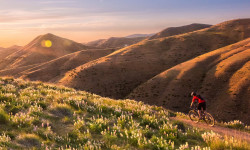
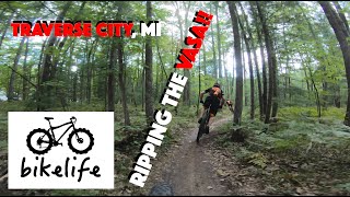
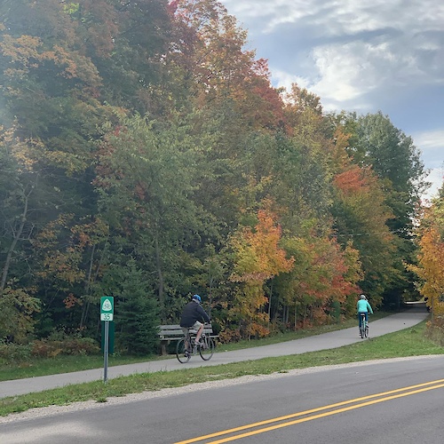
SaveLocated on state forest land, the Vasa Pathway features a series of loops (3K, 5K, 10K, 25K) that offer users a variety of challenges from easy to difficult. Cross-country skiers, runners, hikers, mountain bikers, walkers, and naturalists enjoy the Vasa Pathway. The Vasa Pathway is maintained and groomed by TART Trails under an agreement with the Michigan Department of Natural Resources and Grand Traverse County. It is the home of the North American Vasa cross-country ski race, and the annual Iceman Cometh mountain bike race uses a portion of the trail.
The Vasa Pathway is owned by the Michigan DNR and groomed by TART Trails through a contract with the MDNR. The Vasa Pathway is groomed regularly by TART Trails and includes a skate lane and two classic tracks when possible providing 3k, 5k, 10k & 25k trail loops that feature rolling hills and a few challenging climbs.
Hunting is permitted on DNR property. Use caution and wear blaze orange or bright colors during hunting seasons.
source: TART Website
Primary Trail Type: Cross-Country
 google parking directions
 Access Info:
Trailhead: 4450 Bartlett Rd, Williamsburg, MI 49690
Directions: US31 to Bunker Hill Rd, RIGHT on Bartlett, LEFT into trailhead parking area. The trail is marked with wayfinding signs.
Directions: US31 to Bunker Hill Rd, RIGHT on Bartlett, LEFT into trailhead parking area. The trail is marked with wayfinding signs.
Links
Activities Click to view
- Mountain Bike
22 trails
- Hike
20 trails
- Trail Running
20 trails
- Snowshoe
21 trails
- Nordic Ski
22 trails
Region Details
- 7
- 6
- 9
Region Status
Open as of Jun 21, 2026Stats
- Avg Trail Rating
- Trails (view details)
- 22
- Trails Mountain Bike
- 22
- Trails Winter Fat Bike
- 2
- Trails Hike
- 20
- Trails Trail Running
- 20
- Trails Snowshoe
- 21
- Trails Nordic Ski
- 22
- Total Distance
- 21 miles
- Total Descent Distance
- 8 miles
- Total Descent
- 1,190 ft
- Total Vertical
- 274 ft
- Highest Trailhead
- 974 ft
- Reports
- 434
- Photos
- 9
- Ridden Counter
- 14,054
Articles
The Best Summer Weekend Trips of 2025
Jun 3, 2025 from outsideonline.com
There are only 14 weekends between Memorial Day and Labor Day this year. So you better make them count.
Popular VASA Pathway Mountain Biking Trails
• 100 ★ 4.4 • 4,334 ft • 32 ft • 1,017 •
Popular black diamond difficulty singletrack. This multi-use trail can be used downhill only. On average it takes 3 minutes to complete this trail.
• 100 ★ 4.0 • 2 miles • 113 ft • 891 •
Popular black diamond difficulty singletrack. This multi-use trail can be used downhill only. On average it takes 11 minutes to complete this trail.
• 100 ★ 4.5 • 5,194 ft • 74 ft • 881 •
Popular blue difficulty singletrack. This multi-use trail can be used downhill only. On average it takes 5 minutes to complete this trail.
• 95 ★ 5.0 • 1,096 ft • 0 ft • 747 •
Popular black diamond difficulty singletrack. This multi-use trail can be used downhill only. On average it takes minutes to complete this trail.
• 100 ★ 5.0 • 4,961 ft • 3 ft • 742 •
Popular green difficulty singletrack. This multi-use trail can be used downhill only. On average it takes 4 minutes to complete this trail.
• 95 ★ 5.0 • 4,734 ft • 21 ft • 736 •
Popular black diamond difficulty singletrack. This multi-use trail can be used downhill only. On average it takes 3 minutes to complete this trail.
• 90 ★ 5.0 • 948 ft • 0 ft • 552 •
Popular green difficulty singletrack. This multi-use trail can be used downhill only. On average it takes minutes to complete this trail.
• 80 ★ 0.0 • 3,136 ft • 28 ft • 514 •
Popular black diamond difficulty singletrack. This multi-use trail can be used both directions. On average it takes 3 minutes to complete this trail.
VASA Pathway Mountain Bike Routes
Vasa Pathway Featured
14 miles • 914 ft • 0 • Loop •
6 miles • 170 ft • 1 • Loop •
This is my lunchtime fatbike route when I can get out there. So far this winter it's been among my...
44 miles • 1,749 ft • 38 • Loop •
A mix of multi use trail, Up to date singe track and even some unmarked goodness.
5 miles • 143 ft • 0 •
A slightly shorter version of the 6 mile lunchtime loop. Hang a left just before the bench instead of just...
Photos of VASA Pathway Mountain Bike


Current Trail Warnings
| status | trail | date | condition | user | info |
|---|---|---|---|---|---|
| Vasa #10 - #11 By-Pass | Jun 21, 2026 @ 7:50am (America/Detroit) Jun 21, 2026 | Ideal | Lobo507 | tree down |
Recent Trail Reports
| status | trail | date | condition | info | user |
|---|---|---|---|---|---|
| Wall Bypass | May 24, 2026 @ 9:32pm (America/Detroit) May 24, 2026 | Ideal | Schultz1969 NMMBA | ||
| Riley's | May 24, 2026 @ 9:32pm (America/Detroit) May 24, 2026 | Ideal | Schultz1969 NMMBA | ||
| Vasa #15 - #2 | May 24, 2026 @ 9:32pm (America/Detroit) May 24, 2026 | Ideal | Schultz1969 NMMBA | ||
| Vasa #14 - #15 | May 24, 2026 @ 9:32pm (America/Detroit) May 24, 2026 | Ideal | Schultz1969 NMMBA | ||
| Vasa #13 - #14 | May 24, 2026 @ 9:32pm (America/Detroit) May 24, 2026 | Ideal | Schultz1969 NMMBA | ||
| Vasa #12 - #13 | May 24, 2026 @ 9:32pm (America/Detroit) May 24, 2026 | Ideal | Schultz1969 NMMBA | ||
| Vasa #11 - #12 | May 24, 2026 @ 9:32pm (America/Detroit) May 24, 2026 | Ideal | Schultz1969 NMMBA | ||
| Vasa #10 - #11 | May 24, 2026 @ 9:32pm (America/Detroit) May 24, 2026 | Ideal | Schultz1969 NMMBA | ||
| Vasa #9 - #10 | May 24, 2026 @ 9:32pm (America/Detroit) May 24, 2026 | Ideal | Schultz1969 NMMBA | ||
| Vasa #8 - #9 | May 24, 2026 @ 9:32pm (America/Detroit) May 24, 2026 | Ideal | Schultz1969 NMMBA |
National Scenic Trails & Official Routes
-
Vasa Pathway, Traverse City
- Mountain Bike
- Hike
- Trail Running
- Snowshoe
- Nordic Ski
Activity Feed
| username | action | type | title | date |
|---|---|---|---|---|
| bhren | wishlist | region | activity #97925268 | Jun 27, 2026 @ 11:59am Jun 27, 2026 |
| Lobo507 | add | report | activity #97532255 | Jun 21, 2026 @ 5:06pm Jun 21, 2026 |
| johnmay99 | wishlist | region | activity #97453610 | Jun 20, 2026 @ 8:50pm Jun 20, 2026 |
| Chrisc87ASt | wishlist | trail | activity #96629598 | Jun 9, 2026 @ 2:26pm Jun 9, 2026 |
| GregRoyBean | ridden | trail | activity #96620773 and 3 more | Jun 9, 2026 @ 11:50am Jun 9, 2026 |
Recent Comments
| username | type | title | comment | date |
|---|---|---|---|---|
| trail | This is NOT a black diamond trail nor is it... | Nov 6, 2024 @ 10:08am Nov 6, 2024 | ||
| trail | Kchu | Apr 27, 2023 @ 5:56pm Apr 27, 2023 |
Nearby Areas
| name | distance | ||||
|---|---|---|---|---|---|
| Vasa Single Track (VST) | 9 | 34 | 1.7 km | ||
| VASA Winter Sports Singletrack | 6 | 1.8 km | |||
| Muncie Lakes Pathway | 4 | 10 | 3 | 4.7 km | |
| Maple Bay Natural Area | 3 | 7.9 km | |||
| Boardman Valley Nature Preserve | 5 | 1 | 8 km |
Local Badges
-

Completionist0 awarded
Activity Type Stats
| activitytype | trails | distance | descent | descent distance | total vertical | rating | global rank | state rank | photos | reports | routes | ridelogs |
|---|---|---|---|---|---|---|---|---|---|---|---|---|
| Mountain Bike | 22 | 21 miles | 1,191 ft | 8 miles | 276 ft | #3,589 | #1,259 | 9 | 434 | 5 | 12,463 | |
| Winter Fat Bike | 2 | 2 miles | 46 ft | 2,346 ft | 43 ft | #876 | #448 | 2 | 1 | |||
| Hike | 20 | 19 miles | 1,145 ft | 8 miles | 276 ft | #9,127 | #3,466 | 434 | 1 | 301 | ||
| Trail Running | 20 | 19 miles | 1,145 ft | 8 miles | 276 ft | #8,347 | #2,906 | 434 | 1 | 147 | ||
| Snowshoe | 21 | 20 miles | 1,188 ft | 8 miles | 276 ft | #614 | #251 | 46 | 1 | 13 | ||
| Nordic Ski | 22 | 21 miles | 1,191 ft | 8 miles | 276 ft | #520 | #155 | 46 | 1 | 484 |
Frequently Asked Questions About VASA Pathway
▼
What are the highest rated mountain biking trails in VASA Pathway?
The highest rated mountain biking trails in VASA Pathway are:
- Vasa #12 - #13 (4.2/5)
- Vasa #2 - #3 (4.2/5)
- Vasa #9 - #10 (4.2/5)
- Vasa #14 - #15 (4.1/5)
- Vasa #3 - #4 (4.1/5)
▼
What is the best time of the year to ride in VASA Pathway?
Based on ride log data, the most popular months to ride in VASA Pathway are:
- July (78 activities)
- August (66 activities)
- October (59 activities)
▼
Where can I park to ride in VASA Pathway?
There are 2 parking locations listed in VASA Pathway. The most popular parking spots are:
▼
What is the longest trail in VASA Pathway?
The longest trail in VASA Pathway is Vasa #11 - #12 at 2.1 miles. View all trails sorted by distance.
Activities
- By markholloway
 Trailforks Map Team & contributors
 - Admins: NMMBA, NMMBA
- #11912 - 14,072 views
- vasa pathway activity log | embed map of VASA Pathway mountain bike trails | vasa pathway mountain biking points of interest
Downloading of trail gps tracks in kml & gpx formats is enabled for VASA Pathway.
You must login to download files.