close
-
Layers w
- Weather Layers
- Pro
- Pro
- Pro
- Pro
- Pro
- Pro
- More Layers
- Pro
- Pro
- Pro
- Pro
-
Upgrade to

3D
Trail Conditions
- Unknown
- Snow Groomed
- Snow Packed
- Snow Covered
- Snow Cover Partial
- Freeze/thaw Cycle
- Icy
- Prevalent Mud
- Wet
- Variable
- Ideal
- Dry
- Very Dry
Trail Flow (Ridden Direction)
Trailforks scans users ridelogs to determine the most popular direction each trail is ridden. A good flowing trail network will have most trails flowing in a single direction according to their intension.
The colour categories are based on what percentage of riders are riding a trail in its intended direction.
The colour categories are based on what percentage of riders are riding a trail in its intended direction.
- > 96%
- > 90%
- > 80%
- > 70%
- > 50%
- < 50%
- bi-directional trail
- no data
Trail Last Ridden
Trailforks scans ridelogs to determine the last time a trail was ridden.
- < 2 days
- < 1 week
- < 2 weeks
- < 1 month
- < 6 months
- > 6 months
Trail Ridden Direction
The intended direction a trail should be ridden.
- Downhill Only
- Downhill Primary
- Both Directions
- Uphill Primary
- Uphill Only
- One Direction
Contribute Details
Colors indicate trail is missing specified detail.
- Description
- Photos
- Description & Photos
- Videos
Trail Popularity ?
Trailforks scans ridelogs to determine which trails are ridden the most in the last 9 months.
Trails are compared with nearby trails in the same city region with a possible 25 colour shades.
Think of this as a heatmap, more rides = more kinetic energy = warmer colors.
- most popular
- popular
- less popular
- not popular
ATV/ORV/OHV Filter
Max Vehicle Width
inches
US Cell Coverage
Legend

Radar Time
Activity Recordings
Trailforks uses anonymized public activity data.
?
Activity Recordings
Trailforks uses anonymized public activity data.
?
Personal Heatmap
▶
Activity Types
all
/
none
▶
Options
2
Date range
month
–
Winter Trails
Warning
A routing network for winter maps does not exist. Selecting trails using the winter trails layer has been disabled.
Missing Trails
Most Popular
Least Popular
Trails are colored based on popularity. The more popular a trail is, the more red. Less popular trails trend towards green.
Jump Magnitude Heatmap
Heatmap of where riders jump on trails. Zoom in to see individual jumps, click circles to view jump details.
BC Backroad Status
![map legend]()
Service Road Atlas is a free to use, community-driven service for viewing and creating reports on the numerous back-country service roads around B.C. and Alberta.

Slope Aspect
Direction the slope faces
Trails Deemphasized
Trails are shown in grey.
Only show trails with no bike usage.
Suggested Layers
Based on selected activity type
Save the current map location and zoom level as your default home location whenever this page is loaded.
Save
No description for Wallingford has been added yet!
Login or register to submit one.
Activities Click to view
- Mountain Bike
96 trails
- E-Bike
26 trails
- Adaptive Bike
2 trails
- Horse
36 trails
- Hike
104 trails
- Trail Running
104 trails
Region Details
- 14
- 36
- 22
- 6
- 1
Region Status
Open as of Jul 4, 2026Stats
- Avg Trail Rating
- Trails (view details)
- 80
- Trails Mountain Bike
- 100
- Trails E-Bike
- 26
- Trails Gravel Bike
- 7
- Trails Adaptive Bike
- 2
- Trails Winter Fat Bike
- 8
- Trails Horse
- 36
- Trails Hike
- 104
- Trails Trail Running
- 104
- Trails Observed Trials
- 1
- Total Distance
- 33 miles
- Total Descent
- 3,580 ft
- Total Vertical
- 793 ft
- Highest Trailhead
- 831 ft
- Reports
- 684
- Photos
- 54
- Ridden Counter
- 12,893
Sub Regions
-
Marcus Cooke Memorial Park
- 2
- 1
-
Orchard and Spruce Glen
-
Tyler Mill Preserve
- 31
- 23
- 7
- 1
Popular Wallingford Mountain Biking Trails
• 80 ★ 4.0 • 4,564 ft • 81 ft • 340 •
Preserve. Challenging with some tight turns and close trees, and short punchy climbs.
• 95 ★ 4.0 • 2,005 ft • 36 ft • 329 •
Popular green difficulty singletrack. This multi-use trail can be used both directions. On average it takes 3 minutes to complete this trail.
• 80 ★ 5.0 • 2,795 ft • 52 ft • 317 •
Popular black diamond difficulty singletrack. This mountain bike primary trail and has a hard overall physical rating with a 52 ft blue climb. It features berm, drop and jump. Exposure: High Risk of Serious Injury. Adaptive MTB rating: amtb black. Trail visibility is always easy to follow. On average it takes 5 minutes to complete this trail.
• 100 ★ 4.0 • 548 ft • 0 ft • 295 •
Popular blue difficulty singletrack. This multi-use trail can be used both directions. On average it takes minutes to complete this trail.
• 75 ★ 4.0 • 738 ft • 0 ft • 287 •
Popular green difficulty singletrack. This multi-use trail can be used both directions. On average it takes minutes to complete this trail.
• 100 ★ 0.0 • 479 ft • 25 ft • 271 •
Back in the day, everyone used this as the first portion of the .
• 100 ★ 4.5 • 1,007 ft • 10 ft • 270 •
Popular green difficulty singletrack. This multi-use trail can be used both directions. On average it takes 1 minutes to complete this trail.
• 85 ★ 5.0 • 2 miles • 80 ft • 261 •
The is one of the oldest at Tyler Mill. It was blazed with White Diamonds when the Water Company owned the land. The town of Wallingford bought the parcel with a recreation grant, ensuring this classic trail will stay open and glorious...
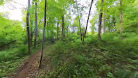
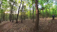
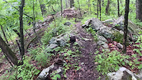
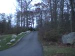
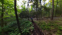
Photos of Wallingford Mountain Bike
Videos of Wallingford Mountain Bike
trail: White Diamond
2:02 |
141 |
May 19, 2023
trail: White Diamond
0:34 |
62 |
May 19, 2023
trail: High Meadow
0:25 |
411 |
Apr 3, 2023
0:11 |
312 |
Nov 13, 2008

trail: Teeter
0:08 |
527 |
Oct 25, 2007
trail: White Diamond
0:47 |
49 |
May 19, 2023
Recent Trail Reports
| status | trail | date | condition | info | user |
|---|---|---|---|---|---|
| Middle Kingdom | Jun 24, 2026 @ 9:31pm (America/New_York) Jun 24, 2026 | Ideal | blackbart2 Tyler Mill | ||
| Brave Ulysses (North) | Mar 31, 2026 @ 1:24pm (America/New_York) Mar 31, 2026 | Ideal | bluewood | ||
| Sidewinder | Mar 31, 2026 @ 1:24pm (America/New_York) Mar 31, 2026 | Ideal | bluewood | ||
| Buck Sheds | Mar 31, 2026 @ 1:24pm (America/New_York) Mar 31, 2026 | Ideal | bluewood | ||
| Boy Scout Trail | Mar 31, 2026 @ 1:24pm (America/New_York) Mar 31, 2026 | Ideal | bluewood | ||
| Barrett's Crossing | Mar 31, 2026 @ 1:24pm (America/New_York) Mar 31, 2026 | Ideal | bluewood | ||
| Brave Ulysses (South) | Mar 31, 2026 @ 1:24pm (America/New_York) Mar 31, 2026 | Ideal | bluewood | ||
| Red Connector | Oct 19, 2025 @ 4:10pm (America/New_York) Oct 19, 2025 | Ideal | grtanner | ||
| Zig-Zag 2.0 | Oct 2, 2025 @ 1:07pm (America/New_York) Oct 2, 2025 | Ideal | blackbart2 Tyler Mill | ||
| Yellow | Oct 2, 2025 @ 1:07pm (America/New_York) Oct 2, 2025 | Ideal | blackbart2 Tyler Mill |
Activity Feed
| username | action | type | title | date |
|---|---|---|---|---|
| blackbart2 | add | report | activity #97739493 | Jun 24, 2026 @ 6:31pm Jun 24, 2026 |
| Dchicarilli | wishlist | trail | activity #97592934 and 1 more | Jun 22, 2026 @ 5:01pm Jun 22, 2026 |
| ralf-s | vote | trail | activity #97057034 and 3 more | Jun 15, 2026 @ 11:53am Jun 15, 2026 |
| Deep8dMZQm | wishlist | trail | activity #95751808 | May 28, 2026 @ 7:31pm May 28, 2026 |
| MathiasS | ridden | trail | activity #95543381 | May 25, 2026 @ 10:00pm May 25, 2026 |
Recent Comments
| username | type | title | comment | date |
|---|---|---|---|---|
| report | Tree blocking path | Mar 23, 2025 @ 1:12pm Mar 23, 2025 | ||
| report | ... | Jul 4, 2024 @ 6:24am Jul 4, 2024 | ||
| trail | Big downed trees after recent storm | Jul 3, 2024 @ 5:40pm Jul 3, 2024 | ||
| report | tree removed | Apr 29, 2023 @ 2:33pm Apr 29, 2023 | ||
| report | A good Samaritan removed hanging hemlock... | Apr 18, 2023 @ 5:07pm Apr 18, 2023 |
Local Badges
-

10 Blue Trails161 awarded -

Epic Ride Climb 2k2 awarded -

Climbing 10k Badge15 awarded -

Climbing 100k Badge0 awarded -

Epic Ride Descent 2k2 awarded -

Descent 10k Badge15 awarded
Activity Type Stats
| activitytype | trails | distance | descent | descent distance | total vertical | rating | global rank | state rank | photos | reports | routes | ridelogs |
|---|---|---|---|---|---|---|---|---|---|---|---|---|
| Mountain Bike | 96 | 27 miles | 2,533 ft | 11 miles | 387 ft | #1,970 | #720 | 70 | 691 | 5,925 | ||
| E-Bike | 26 | 3 miles | 135 ft | 4,157 ft | 328 ft | #6,975 | #2,091 | 1 | 496 | 573 | ||
| Gravel Bike | 7 | #3,572 | #1,321 | 1 | 11 | |||||||
| Adaptive Bike | 2 | #772 | #1,960 | 1 | ||||||||
| Winter Fat Bike | 8 | #3,572 | #1,321 | |||||||||
| Horse | 36 | 9 miles | 889 ft | 4 miles | 180 ft | #2,314 | #1,281 | 1 | 253 | 1 | ||
| Hike | 104 | 33 miles | 3,579 ft | 13 miles | 794 ft | #4,939 | #1,743 | 7 | 688 | 179 | ||
| Trail Running | 104 | 33 miles | 3,579 ft | 13 miles | 794 ft | #4,504 | #1,384 | 688 | 110 | |||
| Observed Trials | 1 | 1,070 ft | 243 ft | 7 ft | 8 | 19 |
Frequently Asked Questions About Wallingford
▼
What are the best places to ride in Wallingford?
Wallingford has 3 areas to explore for mountain biking. The top rated areas are:
▼
What are the highest rated mountain biking trails in Wallingford?
The highest rated mountain biking trails in Wallingford are:
- High Meadow (4.4/5)
- White Diamond (4.3/5)
- Purple Majesty (Double Drops) (4.3/5)
- Half Moon (4.2/5)
- Brave Ulysses (South) (4.2/5)
▼
What is the best time of the year to ride in Wallingford?
Based on ride log data, the most popular months to ride in Wallingford are:
- July (136 activities)
- September (132 activities)
- June (118 activities)
▼
Where can I park to ride in Wallingford?
There are 15 parking locations listed in Wallingford. The most popular parking spots are: View all parking and trailhead locations on the map to plan your visit.
Activities
Trails
- By captainkickstand & contributors
- Admins: HCH, NEMBAEXEC
- #5875 - 4,541 views
- wallingford activity log | embed map of Wallingford mountain bike trails | wallingford mountain biking points of interest
Downloading of trail gps tracks in kml & gpx formats is enabled for Wallingford.
You must login to download files.