- Trail:
- Catalyst (Don Valley)
- Status:
- Significant Issue / Amber
-
Issue status:
- Condition:
- Ideal - Hero dirt! Not wet but not dry, moisture in soil.
- Reporter Primary Activity:
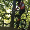
- Mountain Bike
Description:
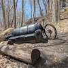
Mud slide covering a section of trail near the beginning, can get around it fairly easy. https://www.trailforks.com/report/4514000/ still has Beth Nealson drive impassable. Watch out if using Old Catalyst to get to Beaver Flats as someone(s) is doing some trail improvements that doesnt seem to include non jumpers.
close
-
Layers w
- Weather Layers
- Pro
- Pro
- Pro
- Pro
- Pro
- Pro
- More Layers
- Pro
- Pro
- Pro
- Pro
-
Upgrade to

3D
Trail Conditions
- Unknown
- Snow Groomed
- Snow Packed
- Snow Covered
- Snow Cover Partial
- Freeze/thaw Cycle
- Icy
- Prevalent Mud
- Wet
- Variable
- Ideal
- Dry
- Very Dry
Trail Flow (Ridden Direction)
Trailforks scans users ridelogs to determine the most popular direction each trail is ridden. A good flowing trail network will have most trails flowing in a single direction according to their intension.
The colour categories are based on what percentage of riders are riding a trail in its intended direction.
The colour categories are based on what percentage of riders are riding a trail in its intended direction.
- > 96%
- > 90%
- > 80%
- > 70%
- > 50%
- < 50%
- bi-directional trail
- no data
Trail Last Ridden
Trailforks scans ridelogs to determine the last time a trail was ridden.
- < 2 days
- < 1 week
- < 2 weeks
- < 1 month
- < 6 months
- > 6 months
Trail Ridden Direction
The intended direction a trail should be ridden.
- Downhill Only
- Downhill Primary
- Both Directions
- Uphill Primary
- Uphill Only
- One Direction
Contribute Details
Colors indicate trail is missing specified detail.
- Description
- Photos
- Description & Photos
- Videos
Trail Popularity ?
Trailforks scans ridelogs to determine which trails are ridden the most in the last 9 months.
Trails are compared with nearby trails in the same city region with a possible 25 colour shades.
Think of this as a heatmap, more rides = more kinetic energy = warmer colors.
- most popular
- popular
- less popular
- not popular
ATV/ORV/OHV Filter
Max Vehicle Width
inches
US Cell Coverage
Legend

Radar Time
Activity Recordings
Trailforks uses anonymized public activity data.
?
Activity Recordings
Trailforks uses anonymized public activity data.
?
Personal Heatmap
▶
Activity Types
all
/
none
▶
Options
2
Date range
month
–
Winter Trails
Warning
A routing network for winter maps does not exist. Selecting trails using the winter trails layer has been disabled.
Missing Trails
Most Popular
Least Popular
Trails are colored based on popularity. The more popular a trail is, the more red. Less popular trails trend towards green.
Jump Magnitude Heatmap
Heatmap of where riders jump on trails. Zoom in to see individual jumps, click circles to view jump details.
BC Backroad Status
![map legend]()
Service Road Atlas is a free to use, community-driven service for viewing and creating reports on the numerous back-country service roads around B.C. and Alberta.

Slope Aspect
Direction the slope faces
Trails Deemphasized
Trails are shown in grey.
Only show trails with no bike usage.
Suggested Layers
Based on selected activity type
Save the current map location and zoom level as your default home location whenever this page is loaded.
SaveCoordinates: 43.710346, -79.345264
Coordinates: 43.711711, -79.343547
Local Weather During Report
- Summary
MostlyClear - Temperature
9° (6°/17°) - Precip
0 mm/h - Wind
10.52 km/h - Cloud Cover
32% - Humidity
0.43
Previous Reports
6 Comments
- + 1
carpediem1
Apr 25, 2026 at 6:13
Thanks all! It would be cool if PA turned into a loop trail with the bottom section of beaver flats. Need a connector lower on the back of what used to be called Rim Job. Probably a bit too marshy down low though.
- + 1
Sorry, can you get around Beth Nealson like last year? Heading out today for my first ride, but would likely skip PA/Catalyst if you can't get past the Ontario Line stuff.
- + 1
I was talking to a guy yesterday who had tried to go through Catalyst and couldn't find any way through into PA, so you probably won't have much luck there.
- + 1
With Beth Nealson getting dug out they have a fence blocking the other side of the road as well. The only way to get to PA would be to head back along Cata back to the beginning and taking the other trails or paved path to the north end of Beaver Flats and then up PA upline but I havent tried it that way yet. Many other longer ways around as well.
- + 1
@Base93: I'm not sure if PA upline is still accessible, but there's a point earlier on Beaver Flats where you can just walk up the hill 10 feet to PA.
I've also seen taking Vanderhoof Hill to Wicksteed suggested, but I haven't seen that confirmed to be open yet.
I've also seen taking Vanderhoof Hill to Wicksteed suggested, but I haven't seen that confirmed to be open yet.