more stats
1.0 mile
Distance
214 ft
Climb
-113 ft
Descent
00:12:03
Avg time
102 ft
Altitude change
303 ft
Altitude min
406 ft
Altitude max
303 ft
Altitude start
407 ft
Altitude end
1.8%
Grade
-20.5%
Grade max
27.2%
Grade min
2,890 ft
Distance climb
1,594 ft
Distance down
1,033 ft
Distance flat
00:12:03
Avg time

Catalyst Details

  • Activities
    • Mountain Bike
    • E-Bike
    • Hike
    • Trail Running
    • Snowshoe
  • Riding Area
    Don Valley
    Toronto, Ontario
  • Difficulty Rating
  • Voted Difficulty
    Black Diamond (3 votes)
  • Local Popularity
    95 in Mountain Biking [+]
    • 95 in E-Biking
    • 80 in Trail Running
    • 65 in Hiking
    • 5 in Snowshoeing
  • Global Ranking
    #711 in Mountain Biking [+]
    • #13917 in E-Biking
    • #151 in Trail Running
    • #1231 in Hiking
    • #1339 in Snowshoeing
  • Trail Type
    Singletrack
  • Bike Type
    AM, XC
  • Direction
    Uphill Primary
    Popular Direction Shown
  • Climb Difficulty
    Black Diamond
  • Physical Rating
    Hard
  • Trail Visibility
    Always easy to follow
  • Dogs Allowed
    Yes
  • eBike Allowed
    Yes up to Class 1
  • TTFs on Trail
    Bridge, Drop, Jump, Gap Jump, Ladder Bridge, Skinny, Teeter Totter
  • Land Owner
    City of Toronto / Toronto Region Conservation Authority

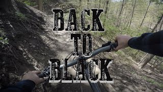
Popular and challenging trail: well loved by many. Steep climbs. Switchbacks. Primarily located on a ravine wall. Very dangerous when wet.

Access Info

Branches off of Beaver Flats

This trail is unsanctioned.

Recent Activity on Trail

Past Week
  • 9 rides
  • 17 miles average
6 Months
  • 25 rides
  • 14 miles avg distance
All
  • 2,327 rides
  • Last: Jun 3, 2026
c1c2c3c4
January
February
March
April
May
June
July
August
September
October
November
December
update trails status or condition

Catalyst Trail Reports

statusdatedescription
Jun 1, 2026 @ 1:13pm (America/Toronto)
3 days
It’s really good! I rode until the construction and then hike a biked around, up to the hydro tower, and took the old Sky Pilot down walking,...
Apr 24, 2026 @ 6:52pm (America/Toronto)
Apr 24, 2026
built a ride around for the mudslide with an old piece of lumber and some logs. Farther down the trail, cleaned several drain areas so mud isn't...
Apr 23, 2026 @ 4:36pm (America/Toronto)
Apr 23, 2026
Mud slide covering a section of trail near the beginning, can get around it fairly easy. https://www.trailforks.com/report/4514000/ still has...
Apr 11, 2026 @ 3:17pm (America/Toronto)
Apr 11, 2026
Fallen tree
Mar 30, 2026 @ 7:43pm (America/Toronto)
Mar 30, 2026
A little bit more wet than would be ideal. I exited at Old Catalyst so I'm not sure the status after. There are some trees falling over on the...
more »
Status:
on Jun 1, 2026
Variable
Avg: 3.81 (26 votes)
Your vote: 0

view (17,850)
close
3D
Trail Conditions
  • Unknown
  • Snow Groomed
  • Snow Packed
  • Snow Covered
  • Snow Cover Partial
  • Freeze/thaw Cycle
  • Icy
  • Prevalent Mud
  • Wet
  • Variable
  • Ideal
  • Dry
  • Very Dry
Trail Flow (Ridden Direction)
Trailforks scans users ridelogs to determine the most popular direction each trail is ridden. A good flowing trail network will have most trails flowing in a single direction according to their intension.
The colour categories are based on what percentage of riders are riding a trail in its intended direction.
  • > 96%
  • > 90%
  • > 80%
  • > 70%
  • > 50%
  • < 50%
  • bi-directional trail
  • no data
Trail Last Ridden
Trailforks scans ridelogs to determine the last time a trail was ridden.
  • < 2 days
  • < 1 week
  • < 2 weeks
  • < 1 month
  • < 6 months
  • > 6 months
Trail Ridden Direction
The intended direction a trail should be ridden.
  • Downhill Only
  • Downhill Primary
  • Both Directions
  • Uphill Primary
  • Uphill Only
  • One Direction
Contribute Details
Colors indicate trail is missing specified detail.
  • Description
  • Photos
  • Description & Photos
  • Videos
Trail Popularity ?
Trailforks scans ridelogs to determine which trails are ridden the most in the last 9 months. Trails are compared with nearby trails in the same city region with a possible 25 colour shades. Think of this as a heatmap, more rides = more kinetic energy = warmer colors.
  • most popular
  • popular
  • less popular
  • not popular
ATV/ORV/OHV Filter
Max Vehicle Width
inches
US Cell Coverage
Legend
cell carrier legend

Radar Time
Activity Recordings
Trailforks uses anonymized public activity data. ?
Activity Recordings
Trailforks uses anonymized public activity data. ?
Personal Heatmap
Activity Types
all / none
Options
2
Date range month
Winter Trails
Warning A routing network for winter maps does not exist. Selecting trails using the winter trails layer has been disabled.
Missing Trails
Most Popular
Least Popular
Trails are colored based on popularity. The more popular a trail is, the more red. Less popular trails trend towards green.
Jump Magnitude Heatmap
Heatmap of where riders jump on trails. Zoom in to see individual jumps, click circles to view jump details.
BC Backroad Status

Service Road Atlas is a free to use, community-driven service for viewing and creating reports on the numerous back-country service roads around B.C. and Alberta.

map legend
Slope Aspect
Direction the slope faces
Flat N NE E SE S SW W NW
Trails Deemphasized
Trails are shown in grey.
disable
Only show trails with no bike usage.
Enable
Suggested Layers
Based on selected activity type

    Save the current map location and zoom level as your default home location whenever this page is loaded.
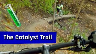
    Save
        Directions to catalyst trailhead (43.704910, -79.337740)

        Photos

        44 more »
        378 |
        Oct 25, 2020 @ 4:06pm
        Oct 25, 2020
        7 |
        Jun 1, 2026 @ 4:19pm
        3 days
        41 |
        May 8, 2026 @ 4:13pm
        May 8, 2026
        50 |
        Aug 11, 2025 @ 5:45am
        Aug 11, 2025

        Videos

        7 more »
        youtuber Trail Riding | Massive CRASH ride with Alistair
        22:42 | 971 | Sep 29, 2020 , Toronto
        youtuber Catalyst - A Black Diamond Trail in the Don...
        0:27 | 2933 | May 20, 2019 , Toronto
        The Catalyst trail - October 2023
        10:51 | 180 | Dec 8, 2024 , Toronto
        Catalyst - Don Valley MTB
        14:16 | 571 | Jul 26, 2022 , Toronto

        Routes with this trail

        5.0 59 miles 5,018 ft 111 Loop
        100k loop through the greater Valley, the route has almost no repeat sections. Consists mostly of...
        4.0 24 miles 2,002 ft 50 Loop
        A route linking together the all the hardest trails throughout the Don Valley. This is a physically...
        3.9 16 miles 1,371 ft 56
        Big loop in the Don featuring a good mix of the standards and the more difficult trails at the north end.

        30 Reviews & Comments


        We hope you've been enjoying Trailforks!

        Create a FREE account to view trail comments and much more.

        • #38687 - 13,798 views

        Frequently Asked Questions About Catalyst

        Where is Catalyst located?
        Catalyst is located in Don Valley, Toronto, Ontario, Canada. It is part of the Don Valley trail network. The trailhead is located at coordinates 43.70491, -79.33774.
        How hard is Catalyst?
        Catalyst is rated as Black Diamond difficulty. The physical rating is Hard. The average grade is 1.8%. The climb difficulty is rated Black Diamond.
        What is the elevation gain for Catalyst?
        Catalyst has 65 m of elevation gain. The trail has 34 m of elevation descent. The elevation ranges from 92 m to 124 m.
        Is Catalyst a point to point trail?
        Catalyst is not a point to point trail. The direction is Uphill Primary. The trail type is singletrack.

        Hit the Trail

        Open in App

        Get this trail on your phone instantly.
        open trail in app

        Download Trail

        Save to wishlist, Garmin & download.
        save the trail

        Find Related Routes

        Find routes and users activities that include this trail.
        find routes for this trail

        You must enter a description before submitting.