
Open in App
Get this route on your phone instantly.
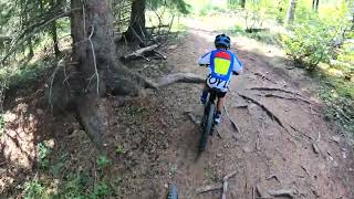
This route is a great introduction for advanced beginners/beginner-intermediate looking for a little challenge. This route offers a nice warm-up on the double track of Telephone Loop. Get Ready for a bit of a climb on disconnect which mellows out into a lovely climb up to Long Distance. This offers a nice variety of terrain, a little bit of flow with some short technical sections of rocks and roots, a quick punchy climb to the first viewpoint which overlooks the couch at Merlin. After a short technical down some rocks to the intersection with Reconnect trail. Turn Left to continue the rest of the climb up Long Distance. There is a bench to stop and take a rest or have a snack. After this point there is a short climb before the main descent. The descent gives a great intro to riders for a nice flow downhill. This descent takes you down to the major intersection. For an easier, less technical descent turn Left at the 3-way intersection at the bottom and take Whitetail over to the telephone to the parking lot.
For a steeper technical downhill (for intermediate riders) take Braggin Rights down to the parking lot.
We hope you've been enjoying Trailforks!
Create a FREE account to view route comments and much more.
| 4,938 ft |

Service Road Atlas is a free to use, community-driven service for viewing and creating reports on the numerous back-country service roads around B.C. and Alberta.
Save the current map location and zoom level as your default home location whenever this page is loaded.
Save| status | trail | date | condition | description |
|---|---|---|---|---|
May 12, 2026 @ 4:57pm (America/Edmonton) May 12, 2026 | Great condition |