14.9 miles
Distance
2,611 ft
Climb
-2,610 ft
Descent
2 miles
High Point
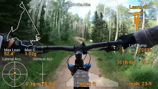
After work big dv loop. Up to silver lake from snow park to top of nail driver back down to the bottom.
Detailed Description
big dv loop is a 15 mile moderately popular intermediate route located near Park City Utah. This mountain bike only route. This route includes 44 trails. This route climbs 2,611 ft with a max elevation of 9,092 ft then descends -2,610 ft.
Local Trail Association
Mountain Trails Foundation (mountaintrails.org)Please consider joining or donating to the local riding association to support trail development & maintenance.
donate to earn trail karma!
Trail Products
45 Reviews & Comments
We hope you've been enjoying Trailforks!
Create a FREE account to view route comments and much more.
Trails in Route
722 ft | |||||
997 ft | |||||
361 ft | |||||
1,516 ft | |||||
679 ft | |||||
1,204 ft | |||||
4,091 ft | |||||
2 miles | |||||
59 ft | |||||
1,398 ft | |||||
2,707 ft | |||||
1,539 ft | |||||
666 ft | |||||
545 ft | |||||
151 ft | |||||
1,184 ft | |||||
3 ft | |||||
1,289 ft | |||||
2,762 ft | |||||
1,260 ft | |||||
20 ft | |||||
2,398 ft | |||||
719 ft | |||||
1,394 ft |
Details
-
Riding area
-
Primary ActivityMountain Bike
-
Difficulty ratingBlue
More Stats for big dv loop mountain bike route
-
Avg time5 hr 55 min
-
Altitude change0 ft
-
Altitude min7,212 ft
-
Altitude start7,241 ft
-
Altitude end7,241 ft
-
Grade max-94.1%
-
Grade min37%
-
Distance climb8 miles
-
Distance down6 miles
-
Distance flat1 mile
close
3D
Trail Conditions
- Unknown
- Snow Groomed
- Snow Packed
- Snow Covered
- Snow Cover Partial
- Freeze/thaw Cycle
- Icy
- Prevalent Mud
- Wet
- Variable
- Ideal
- Dry
- Very Dry
Trail Flow (Ridden Direction)
Trailforks scans users ridelogs to determine the most popular direction each trail is ridden. A good flowing trail network will have most trails flowing in a single direction according to their intension.
The colour categories are based on what percentage of riders are riding a trail in its intended direction.
- > 96%
- > 90%
- > 80%
- > 70%
- > 50%
- < 50%
- bi-directional trail
- no data
Trail Last Ridden
Trailforks scans ridelogs to determine the last time a trail was ridden.
- < 2 days
- < 1 week
- < 2 weeks
- < 1 month
- < 6 months
- > 6 months
Trail Ridden Direction
The intended direction a trail should be ridden.
- Downhill Only
- Downhill Primary
- Both Directions
- Uphill Primary
- Uphill Only
- One Direction
Contribute Details
Colors indicate trail is missing specified detail.
- Description
- Photos
- Description & Photos
- Videos
Trail Popularity ?
Trailforks scans ridelogs to determine which trails are ridden the most in the last 9 months.
Trails are compared with nearby trails in the same city region with a possible 25 colour shades.
Think of this as a heatmap, more rides = more kinetic energy = warmer colors.
- most popular
- popular
- less popular
- not popular
ATV/ORV/OHV Filter
Max Vehicle Width
inches
US Cell Coverage
Legend
Radar Time
x
Activity Recordings
Trailforks users anonymized public ridelogs from the past 6 months.
- mountain biking recent
- mountain biking (>6 month)
- hiking (1 year)
- moto (1 year)
Activity Recordings
Trailforks users anonymized public skilogs from the past 12 months.
- Downhill Ski
- Backcountry Ski
- Nordic Ski
- Snowmobile
Winter Trails
Warning
A routing network for winter maps does not exist. Selecting trails using the winter trails layer has been disabled.
x
Missing Trails
Most Popular
Least Popular
Trails are colored based on popularity. The more popular a trail is, the more red. Less popular trails trend towards green.
Jump Magnitude Heatmap
Heatmap of where riders jump on trails. Zoom in to see individual jumps, click circles to view jump details.
Trails Deemphasized
Trails are shown in grey.
Only show trails with NO bikes.
Save the current map location and zoom level as your default home location whenever this page is loaded.
Save
Trail transparency
Photos
Videos
Recent Trail Reports Along Route
status | trail | date | condition | description |
---|---|---|---|---|
Nov 5, 2024 @ 9:10am Nov 5, 2024 | ||||
Nov 5, 2024 @ 9:09am Nov 5, 2024 | ||||
Nov 5, 2024 @ 9:09am Nov 5, 2024 |
- By mtnranks & contributors
- #9076 - 1,199 views