26.1 miles
Distance
6,148 ft
Climb
-6,149 ft
Descent
4,900 ft
High Point
-4 ft
Altitude change
901 ft
Altitude min
964 ft
Altitude start
961 ft
Altitude end
-126.8%
Grade max
74.5%
Grade min
12 miles
Distance climb
11 miles
Distance down
2 miles
Distance flat

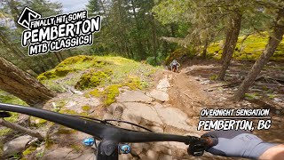
A classic adventure loop. Great views on the climb and several lakes to swim in during your lunch stop. Save something for the final descent, it will require your A game. No cell service once you drop into Skelula7.

Detailed Description
Chain Lakes Loop is a 26 mile popular expert route located near Pemberton British Columbia. This mountain bike only route can be used one direction and has a hard overall physical rating. This route includes 14 trails. This route climbs 6,148 ft with a max elevation of 4,900 ft then descends -6,149 ft.

Trail Issues on Route

  • Significant Issue / Amber: 3 trails (newest: May 31, 2026)
  • Minor Issue / Yellow: 1 trail (newest: Jun 21, 2026)
Local Trail Association
Local trail association
Pemberton Off-road Cycling Association (www.porcabikes.com)
Please consider joining or donating to the local riding association to support trail development & maintenance.
Donate to earn trail karma!

Trail Products

Stats

  • Distance
    26 miles
  • Avg time
    11 hr 7 min
  • Altitude min
    901 ft
  • Altitude start
    964 ft
  • Altitude end
    961 ft
  • Climb
    1 mile
  • Descent
    -6,149 ft
  • Grade max
    -126.8%
  • Grade min
    74.5%
  • Distance climb
    12 miles
  • Distance down
    11 miles
  • Distance flat
    2 miles

24 Reviews & Comments


We hope you've been enjoying Trailforks!

Create a FREE account to view route comments and much more.

Trails in Route

Reid Road1,365 ft
Jim-Jam942 ft
Hand Job1,736 ft
Mosquito Lake Road3,241 ft
Sadies1,161 ft
Linda Road2,500 ft
Connector1,224 ft
Waco Connector141 ft
Nimby2 miles
MacKenzie FSR Connector646 ft
McKenzie FSR1 mile
Middle Earth2 miles
Xtratron5,213 ft
Skalúla74 miles

Details

  • Riding area
  • Primary Activity
    Mountain Bike
  • Difficulty rating
    Black Diamond
  • Route Type
    Loop
  • Bike type
    AM
  • Direction
    One Direction
  • Physical rating
    Hard
Avg: 3 (3 votes)
close
3D
Trail Conditions
  • Unknown
  • Snow Groomed
  • Snow Packed
  • Snow Covered
  • Snow Cover Partial
  • Freeze/thaw Cycle
  • Icy
  • Prevalent Mud
  • Wet
  • Variable
  • Ideal
  • Dry
  • Very Dry
Trail Flow (Ridden Direction)
Trailforks scans users ridelogs to determine the most popular direction each trail is ridden. A good flowing trail network will have most trails flowing in a single direction according to their intension.
The colour categories are based on what percentage of riders are riding a trail in its intended direction.
  • > 96%
  • > 90%
  • > 80%
  • > 70%
  • > 50%
  • < 50%
  • bi-directional trail
  • no data
Trail Last Ridden
Trailforks scans ridelogs to determine the last time a trail was ridden.
  • < 2 days
  • < 1 week
  • < 2 weeks
  • < 1 month
  • < 6 months
  • > 6 months
Trail Ridden Direction
The intended direction a trail should be ridden.
  • Downhill Only
  • Downhill Primary
  • Both Directions
  • Uphill Primary
  • Uphill Only
  • One Direction
Contribute Details
Colors indicate trail is missing specified detail.
  • Description
  • Photos
  • Description & Photos
  • Videos
Trail Popularity ?
Trailforks scans ridelogs to determine which trails are ridden the most in the last 9 months. Trails are compared with nearby trails in the same city region with a possible 25 colour shades. Think of this as a heatmap, more rides = more kinetic energy = warmer colors.
  • most popular
  • popular
  • less popular
  • not popular
ATV/ORV/OHV Filter
Max Vehicle Width
inches
US Cell Coverage
Legend
cell carrier legend

Radar Time
Activity Recordings
Trailforks uses anonymized public activity data. ?
Activity Recordings
Trailforks uses anonymized public activity data. ?
Personal Heatmap
Activity Types
all / none
Options
2
Date range month
Winter Trails
Warning A routing network for winter maps does not exist. Selecting trails using the winter trails layer has been disabled.
Missing Trails
Most Popular
Least Popular
Trails are colored based on popularity. The more popular a trail is, the more red. Less popular trails trend towards green.
Jump Magnitude Heatmap
Heatmap of where riders jump on trails. Zoom in to see individual jumps, click circles to view jump details.
BC Backroad Status

Service Road Atlas is a free to use, community-driven service for viewing and creating reports on the numerous back-country service roads around B.C. and Alberta.

map legend
Slope Aspect
Direction the slope faces
Flat N NE E SE S SW W NW
Trails Deemphasized
Trails are shown in grey.
disable
Only show trails with no bike usage.
Enable
Suggested Layers
Based on selected activity type

    Save the current map location and zoom level as your default home location whenever this page is loaded.

    Save
    Trail transparency
    • Singletrack
    • Unpaved
    • Paved
    48
    543
    728 | 6 faves
    399
    Pemberton is an MTB Sensation!
    Pemberton is an MTB Sensation!
    trail: Jim-Jam
    16:28 | 60 | comments: 0 | favs:
    Sep 23, 2024
    youtuber XTRATRON Adventure (Pemberton MTB Trail)
    XTRATRON Adventure (Pemberton MTB Trail)
    trail: Xtratron
    0:49 | 822 | comments: 0 | favs:
    Sep 27, 2018

    Recent Trail Reports Along Route

    statustraildateconditiondescription
    Waco Connector
    Jun 26, 2026 @ 2:00pm (America/Vancouver)
    Jun 26, 2026
    Nimby
    Jun 26, 2026 @ 2:00pm (America/Vancouver)
    Jun 26, 2026
    MacKenzie FSR Connector
    Jun 26, 2026 @ 2:00pm (America/Vancouver)
    Jun 26, 2026
    Middle Earth
    Jun 23, 2026 @ 3:06pm (America/Vancouver)
    Jun 23, 2026
    Bear alone in the trail. Not nervous. Stayed in the trail and looked at me. I decided to go back and took another trail.
    McKenzie FSR
    Jun 21, 2026 @ 11:05am (America/Vancouver)
    Jun 21, 2026
    June 21, 2026, 9:17 AM I met a cougar at around the 6.5 km mark.The cougar was hiding in the bushes on the side of the FSR and Jumped out right as I was passing by. After jumping out, it kept moving left and right across the path, appearing to look for the right timing to attack. Fortunately, it eventually disappeared into the forest, and I was not directly attacked. Afterward, I teamed up with a dirt biker who happened to pass by. On the way back I spotted another smaller cougar, but this one ran away immediately.
    more reports »
    • By twinoneTF Pro & contributors
    • #2542 - 9,029 views

    Hit the Trail

    Open in App

    Get this route on your phone instantly.

    Download Route

    Save to wishlist, Garmin & download.