

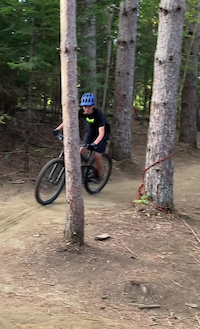
Classic KT is an intermediate level loop that takes riders down the west side of Darling Hill. This route can be characterized by a combination of technical and flow trails. After parking at After that take Vast Downtown to return to the parking lot. Riders will take a right on Bemistps://www.trailforks.com/trails/bemis-479723/]Bemis[/L] until they hit NewT. NewT is a slightly more technical downhill flowing trail. The route then takes you across River Run to West Branch. From there riders will climb West Branch, a beautiful bermed climbing trail. Riders will reach a clearing in the woods. From the clearing, riders will take Border across to Bear Back. Bear Back is a rolling flowy trail that leads back into West Branch and then to the clearing. From there riders can take Old Webs, a short loop trail through a beautiful pine forest. Riders will return back to the clearing and then take Meadow Wood to Beltway, which returns back to Rifugio
Local Trail Association
Kingdom Trail Association (www.kingdomtrails.com)Stats
-
Distance9 miles
-
Altitude change55 ft
-
Altitude min711 ft
-
Altitude start824 ft
-
Altitude end879 ft
-
Climb1,007 ft
-
Descent-939 ft
-
Grade0.1%
-
Grade max-31.8%
-
Grade min39.3%
-
Distance climb4 miles
-
Distance down4 miles
-
Distance flat2 miles
10 Reviews & Comments
We hope you've been enjoying Trailforks!
Create a FREE account to view route comments and much more.
Trails in Route
| 1,585 ft | |||||
| 1,542 ft | |||||
| 1,037 ft | |||||
| 518 ft | |||||
| 4,150 ft | |||||
| 1 mile | |||||
| 226 ft | |||||
| 2,024 ft | |||||
| 1,506 ft | |||||
| 1,184 ft |

Details
-
Riding area
-
Primary ActivityMountain Bike
-
Difficulty ratingBlue
-
eBike Allowed
Directions
- Walk west on Route Vt-114.
- Continue for 100 meters.
- Keep right to take East Darling Hill Road Intersection.
- Continue for 60 meters.
- Bear right onto East Darling Hill Road.
- Continue for 70 meters.
- Turn left onto Uptown.
- Continue for 10 meters.
- Turn left to stay on Uptown.
- Continue for 500 meters.
- Turn left onto Garden Drive.
- Continue for 30 meters.
- Make a sharp left onto Herb's Access Road.
- Continue for 70 meters.
- Walk west on Drop It!.
- Continue for 300 meters.
- Walk southwest on Herb's.
- Continue for 400 meters.
- Bear right onto Sugarhouse Run.
- Continue for 60 meters.
- Turn left onto East Darling Hill Road.
- Continue for 400 meters.
- Bear left onto Darling Hill Road.
- Continue for 2 kilometers.
- Turn right onto Parking Access.
- Continue for 60 meters.
- Walk west on Parking Access.
- Continue for 100 meters.
- Walk southwest on Beltway.
- Continue for 400 meters.
- Keep right to stay on Beltway.
- Continue for 500 meters.
- Keep right to stay on Beltway.
- Continue for 1 kilometer.
- Turn left onto Meadow Wood.
- Continue for 500 meters.
- Keep right to take West Bench.
- Continue for 600 meters.
- Turn right to stay on West Bench.
- Continue for 600 meters.
- Walk northwest on West Branch.
- Continue for 300 meters.
- Turn right onto Hog Back.
- Continue for 300 meters.
- Bear left onto Hog Back Link.
- Continue for 200 meters.
- Keep right to stay on Violets Outback.
- Continue for 10 meters.
- Turn right onto Fox Run.
- Continue for 40 meters.
- Bear right onto Meadow Wood.
- Continue for 200 meters.
- Turn left onto Beltway.
- Continue for 1 kilometer.
- Keep left to stay on Beltway.
- Continue for 900 meters.
- Walk east on Parking Access.
- Continue for 200 meters.
- Turn left onto Darling Hill Road (South).
- Continue for 2 kilometers.
- Turn right onto East Darling Hill Road.
- Continue for 400 meters.
- Turn right onto Sugarhouse Run.
- Continue for 60 meters.
- Keep left to take Herb's.
- Continue for 400 meters.
- Walk south on Drop It!.
- Continue for 300 meters.
- Make a sharp left onto Ide Ride That.
- Continue for 30 meters.
- Walk northeast on Herb's Access Road.
- Continue for 20 meters.
- Unknown
- Snow Groomed
- Snow Packed
- Snow Covered
- Snow Cover Partial
- Freeze/thaw Cycle
- Icy
- Prevalent Mud
- Wet
- Variable
- Ideal
- Dry
- Very Dry
The colour categories are based on what percentage of riders are riding a trail in its intended direction.
- > 96%
- > 90%
- > 80%
- > 70%
- > 50%
- < 50%
- bi-directional trail
- no data
- < 2 days
- < 1 week
- < 2 weeks
- < 1 month
- < 6 months
- > 6 months
- Downhill Only
- Downhill Primary
- Both Directions
- Uphill Primary
- Uphill Only
- One Direction
- Description
- Photos
- Description & Photos
- Videos
- most popular
- popular
- less popular
- not popular
Service Road Atlas is a free to use, community-driven service for viewing and creating reports on the numerous back-country service roads around B.C. and Alberta.
Save the current map location and zoom level as your default home location whenever this page is loaded.
Save- Singletrack
Photos
Videos
Recent Trail Reports Along Route
- By Ilan-KT
KTA & contributors - #67706 - 29 views
