more stats
1.2 miles
Distance
98 ft
Climb
-131 ft
Descent
00:12:14
Avg time
-31 ft
Altitude change
995 ft
Altitude min
1,119 ft
Altitude max
1,104 ft
Altitude start
1,073 ft
Altitude end
-0.5%
Grade
-20.2%
Grade max
12.1%
Grade min
2,822 ft
Distance climb
2,198 ft
Distance down
1,014 ft
Distance flat
00:12:14
Avg time

Loop Details

  • Activities
    • Mountain Bike
    • E-Bike
    • Adaptive Bike
    • Hike
    • Trail Running
  • Riding Area
    Kingdom Trails
    East Burke, Vermont
  • Difficulty Rating
  • Local Popularity
    40 in Mountain Biking [+]
    • 40 in E-Biking
    • 45 in Trail Running
    • 35 in Hiking
  • Global Ranking
    #86990 in Mountain Biking [+]
    • #95808 in E-Biking
    • #117708 in Trail Running
    • #112421 in Hiking
  • Trail Type
    Mixed
  • Bike Type
    AM, XC, Adaptive MTB
  • Direction
    Both Directions
    Popular Direction Shown
  • Climb Difficulty
    Green
  • Physical Rating
    Easy
  • Trail Visibility
    Always easy to follow
  • eBike Allowed
  • TTFs on Trail
    Bridge
  • Land Owner
    Kingdom Trail Association

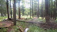
Loop trail is an easy, fun trail that includes sections of dirt road, double track and, in places, what can best be describes as wide singletrack. The surface is generally smooth with no significant obstacles and the elevation changes are gentle, albeit with a few short steeper sections. The Loop is suitable for all skills levels and is favored by families newly minted novices. It traverses a beautiful and varied landscape with some open meadows in the south and an enchanted forest section in the north.

Access Info

Loop runs conveniently from the parking area at Mountain View Farm, loops north through a forested section from where one can access the green Cupcake trail and the more challenging Poundcake trail, after which it turns west and south to join up with the northern end of Bemis, from where it returns back to Mountain View Farm. From Loop you can also access the famous Coronary and Coronary Bypass, as well as Fence Line, Pastore Point and Bog Meadow.

Local Trail Association
Traditionally Indigenous Territory

Recent Activity on Trail

Past Week
  • 2 rides
  • 4 miles average
6 Months
  • 8 rides
  • 11 miles avg distance
All
  • 642 rides
  • Last: Jun 7, 2026
c1c2c3c4
January
February
March
April
May
June
July
August
September
October
November
December
update trails status or condition

Loop Trail Reports

statusdatedescription
Apr 30, 2026 @ 1:27pm (America/New_York)
Apr 30, 2026
reporter
Apr 18, 2026 @ 11:30am (America/New_York)
Apr 18, 2026
reporter The Wildflower Backyard trails are open for the 2026 season! The rest of the network still needs time to dry out, but we will continue to open...
Oct 31, 2025 @ 9:50pm (America/New_York)
Oct 31, 2025
reporter Winter trails will open after Vermont's deer hunting season concludes AND once the ground is frozen. https://www.kingdomtrails.org/Trail-Conditions
Jul 19, 2025 @ 7:46am
Jul 19, 2025
Jul 11, 2025 @ 9:10am
Jul 11, 2025
reporter Trails are open but wet following July 10 storm. Please ride carefully.
more »
Status:
on Apr 30, 2026
Avg: 3.98 (1 votes)
Your vote: 0

view (2,461)
close
3D
Trail Conditions
  • Unknown
  • Snow Groomed
  • Snow Packed
  • Snow Covered
  • Snow Cover Partial
  • Freeze/thaw Cycle
  • Icy
  • Prevalent Mud
  • Wet
  • Variable
  • Ideal
  • Dry
  • Very Dry
Trail Flow (Ridden Direction)
Trailforks scans users ridelogs to determine the most popular direction each trail is ridden. A good flowing trail network will have most trails flowing in a single direction according to their intension.
The colour categories are based on what percentage of riders are riding a trail in its intended direction.
  • > 96%
  • > 90%
  • > 80%
  • > 70%
  • > 50%
  • < 50%
  • bi-directional trail
  • no data
Trail Last Ridden
Trailforks scans ridelogs to determine the last time a trail was ridden.
  • < 2 days
  • < 1 week
  • < 2 weeks
  • < 1 month
  • < 6 months
  • > 6 months
Trail Ridden Direction
The intended direction a trail should be ridden.
  • Downhill Only
  • Downhill Primary
  • Both Directions
  • Uphill Primary
  • Uphill Only
  • One Direction
Contribute Details
Colors indicate trail is missing specified detail.
  • Description
  • Photos
  • Description & Photos
  • Videos
Trail Popularity ?
Trailforks scans ridelogs to determine which trails are ridden the most in the last 9 months. Trails are compared with nearby trails in the same city region with a possible 25 colour shades. Think of this as a heatmap, more rides = more kinetic energy = warmer colors.
  • most popular
  • popular
  • less popular
  • not popular
ATV/ORV/OHV Filter
Max Vehicle Width
inches
US Cell Coverage
Legend
cell carrier legend

Radar Time
Activity Recordings
Trailforks uses anonymized public activity data. ?
Activity Recordings
Trailforks uses anonymized public activity data. ?
Personal Heatmap
Activity Types
all / none
Options
2
Date range month
Winter Trails
Warning A routing network for winter maps does not exist. Selecting trails using the winter trails layer has been disabled.
Missing Trails
Most Popular
Least Popular
Trails are colored based on popularity. The more popular a trail is, the more red. Less popular trails trend towards green.
Jump Magnitude Heatmap
Heatmap of where riders jump on trails. Zoom in to see individual jumps, click circles to view jump details.
BC Backroad Status

Service Road Atlas is a free to use, community-driven service for viewing and creating reports on the numerous back-country service roads around B.C. and Alberta.

map legend
Slope Aspect
Direction the slope faces
Flat N NE E SE S SW W NW
Trails Deemphasized
Trails are shown in grey.
disable
Only show trails with no bike usage.
Enable
Suggested Layers
Based on selected activity type

    Save the current map location and zoom level as your default home location whenever this page is loaded.

    Save
        Directions to loop trailhead (44.593050, -71.961770)

        Photos

        23 more »
        90 |
        Oct 22, 2017 @ 7:16pm
        Oct 22, 2017
        98 |
        Oct 22, 2017 @ 7:16pm
        Oct 22, 2017
        82 |
        Oct 22, 2017 @ 7:12pm
        Oct 22, 2017
        78 |
        Oct 22, 2017 @ 7:12pm
        Oct 22, 2017

        Videos

        3 more »
        A Quick Loop On The Backyard Trails
        2:32 | 288 | Jul 6, 2012 , East Burke
        Riding Trains at Highland Mountain Bike Park
        4:13 | 874 | Nov 6, 2012 , East Burke
        Early morning ride with the Pivot Mach 5.7
        2:14 | 2628 | Aug 4, 2012 , East Burke

        Trail Lists

        Routes with this trail

        4 miles 341 ft 6 Loop
        This scenic is perfect for beginners or riders looking for a beautiful tour of Darling Hill, primarily on...
        3 miles 244 ft 3 Loop
        Kingdom Trails: aMTB Beginner Route - A 3 mile with 300ft of designed for beginner aMTB users! This route...
        3.0 32 miles 3,798 ft 111 Loop
        This loop is a great perimeter loop of KT that touches on almost all the riding areas except for the new...

        1 Review & Comments


        We hope you've been enjoying Trailforks!

        Create a FREE account to view trail comments and much more.

        Frequently Asked Questions About Loop

        Where is Loop located?
        Loop is located in Kingdom Trails, East Burke, Vermont, United States. It is part of the Kingdom Trails trail network. The trailhead is located at coordinates 44.59305, -71.96177.
        How hard is Loop?
        Loop is rated as Green difficulty. The physical rating is Easy. The average grade is 0.5%. The climb difficulty is rated Green.
        What is the elevation gain for Loop?
        Loop has 98 ft of elevation gain. The trail has 131 ft of elevation descent. The elevation ranges from 995 ft to 1,119 ft.
        Is Loop a point to point trail?
        Loop is not a point to point trail. The direction is Both Directions. The trail type is mixed.

        Hit the Trail

        Open in App

        Get this trail on your phone instantly.
        open trail in app

        Download Trail

        Save to wishlist, Garmin & download.
        save the trail

        Find Related Routes

        Find routes and users activities that include this trail.
        find routes for this trail

        You must enter a description before submitting.