7.9 miles
Distance
263 ft
Climb
-261 ft
Descent
635 ft
High Point

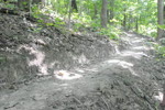
This route covers the majority of the faster drying trails. This route is popular when the trails near the creek are muddy or soft.

Detailed Description
Faster Drying Trails is a 8 mile moderately popular intermediate route located near Portage Indiana. This mountain bike primary route can be used one direction and has a moderate overall physical rating. This route includes 33 trails. This route climbs 263 ft with a max elevation of 635 ft then descends -261 ft.
Local Trail Association
Local trail association
Outback Trail Commission (outbacktrail.org)
Please consider joining or donating to the local riding association to support trail development & maintenance.
donate to earn trail karma!

9 Reviews & Comments


We hope you've been enjoying Trailforks!

Create a FREE account to view route comments and much more.

Details

  • Riding area
  • Primary Activity
    Mountain Bike
  • Other Activities
    • E-Bike
    • Hike
    • Trail Running
  • Difficulty rating
    Blue
  • Route Type
    Loop
  • eBike Allowed
  • Bike type
    DH, AM, XC, Fat
  • Direction
    One Direction
  • Physical rating
    Moderate
  • Ridelogs
    6
More Stats for Faster Drying Trails mountain bike route
  • Avg time
    1 hr 12 min
  • Altitude min
    608 ft
  • Altitude start
    630 ft
  • Altitude end
    630 ft
  • Grade max
    -17.2%
  • Grade min
    15.5%
  • Distance climb
    2 miles
  • Distance down
    2 miles
  • Distance flat
    4 miles
no votes yet
close
3D
Trail Conditions
  • Unknown
  • Snow Groomed
  • Snow Packed
  • Snow Covered
  • Snow Cover Partial
  • Freeze/thaw Cycle
  • Icy
  • Prevalent Mud
  • Wet
  • Variable
  • Ideal
  • Dry
  • Very Dry
Trail Flow (Ridden Direction)
Trailforks scans users ridelogs to determine the most popular direction each trail is ridden. A good flowing trail network will have most trails flowing in a single direction according to their intension.
The colour categories are based on what percentage of riders are riding a trail in its intended direction.
  • > 96%
  • > 90%
  • > 80%
  • > 70%
  • > 50%
  • < 50%
  • bi-directional trail
  • no data
Trail Last Ridden
Trailforks scans ridelogs to determine the last time a trail was ridden.
  • < 2 days
  • < 1 week
  • < 2 weeks
  • < 1 month
  • < 6 months
  • > 6 months
Trail Ridden Direction
The intended direction a trail should be ridden.
  • Downhill Only
  • Downhill Primary
  • Both Directions
  • Uphill Primary
  • Uphill Only
  • One Direction
Contribute Details
Colors indicate trail is missing specified detail.
  • Description
  • Photos
  • Description & Photos
  • Videos
Trail Popularity ?
Trailforks scans ridelogs to determine which trails are ridden the most in the last 9 months. Trails are compared with nearby trails in the same city region with a possible 25 colour shades. Think of this as a heatmap, more rides = more kinetic energy = warmer colors.
  • most popular
  • popular
  • less popular
  • not popular
ATV/ORV/OHV Filter
Max Vehicle Width
inches
US Cell Coverage
Legend
cell carrier legend

Radar Time
x Activity Recordings
Trailforks users anonymized public ridelogs from the past 6 months.
  • mountain biking recent
  • mountain biking (>6 month)
  • hiking (1 year)
  • moto (1 year)
Activity Recordings
Trailforks users anonymized public skilogs from the past 12 months.
  • Downhill Ski
  • Backcountry Ski
  • Nordic Ski
  • Snowmobile
Winter Trails
Warning A routing network for winter maps does not exist. Selecting trails using the winter trails layer has been disabled.
x Missing Trails
Most Popular
Least Popular
Trails are colored based on popularity. The more popular a trail is, the more red. Less popular trails trend towards green.
Jump Magnitude Heatmap
Heatmap of where riders jump on trails. Zoom in to see individual jumps, click circles to view jump details.
Trails Deemphasized
Trails are shown in grey.
disable
Only show trails with NO bikes.
enable

Save the current map location and zoom level as your default home location whenever this page is loaded.

Save
Trail transparency
36
33
330
123
Me n Marko on Heaven N Hell (4c)
trail: Zig Zag
0:15 | 240 | comments: 0 | favs:
Jan 13, 2011
zig zag benchcut on the front 1/2 of 4c between 2nd and 3rd switchbacks . I had to tell the photog to trust me and get loooooow and *right here*.

Recent Trail Reports Along Route

statustraildateconditiondescription
Speedy Ridge
Jun 15, 2025 @ 6:43am
Jun 15, 2025
Bridge damage, more than I’d want to roll the wheel over
Daytona.5
Sep 17, 2024 @ 1:17pm
Sep 17, 2024
Tree down. Passable but a real flow killer!
Penninsula
Aug 19, 2024 @ 3:09pm
Aug 19, 2024
Rich's Revenge
Jan 7, 2024 @ 2:05am
Jan 7, 2024
Be aware of freeze thaw. Trails have decent leaf cover There is 1 tree down, but easily passable
The Balcony
Jan 7, 2024 @ 2:05am
Jan 7, 2024
Be aware of freeze thaw. Trails have decent leaf cover
more reports »
  • By ArmuirTF Pro & contributors
  • #16886 - 850 views