13.9 miles
Distance
2,819 ft
Climb
-2,817 ft
Descent
1,276 ft
High Point
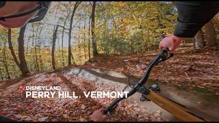
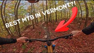
Perry Hill is truly the OG – the defining singletrack network that put Vermont on the map. Perry throws everything at you: huge climbs, monstrous technical descents, GIANT slabs, jumps, gaps… everything. The easier lower trails offer super fast, action packed flow with optional hits galore. Bottom line, you can say other Vermont riding is as good as Perry, but you can’t say it’s better.
Detailed Description
Full Perry is a 14 mile moderately popular expert route located near Waterbury Vermont. This mountain bike only route can be used one direction and has a hard overall physical rating. This route includes 23 trails. This route climbs 2,819 ft with a max elevation of 1,276 ft then descends -2,817 ft.
Route Supporters
Waterbury Area Trails AllianceMaintainer
Local Trail Association
Waterbury Area Trails Alliance (www.waterburytrails.com)Please consider joining or donating to the local riding association to support trail development & maintenance.
donate to earn trail karma!
30 Reviews & Comments
We hope you've been enjoying Trailforks!
Create a FREE account to view route comments and much more.
Trails in Route
200 ft | |||||
4,797 ft | |||||
525 ft | |||||
2,933 ft | |||||
3,360 ft | |||||
4,898 ft | |||||
1,634 ft | |||||
249 ft | |||||
469 ft | |||||
2,933 ft | |||||
3,629 ft | |||||
417 ft | |||||
4,409 ft | |||||
200 ft | |||||
525 ft | |||||
3,760 ft | |||||
1,594 ft | |||||
1 mile |
Details
-
Riding area
-
Primary ActivityMountain Bike
-
Difficulty ratingBlack Diamond
-
Route TypeLoop
-
Bike typeAM
-
DirectionOne Direction
-
Physical ratingHard
More Stats for Full Perry mountain bike route
-
Altitude min436 ft
-
Altitude start436 ft
-
Altitude end436 ft
-
Grade max-48%
-
Grade min32.9%
-
Distance climb7 miles
-
Distance down6 miles
-
Distance flat1 mile
close
3D
Trail Conditions
- Unknown
- Snow Groomed
- Snow Packed
- Snow Covered
- Snow Cover Partial
- Freeze/thaw Cycle
- Icy
- Prevalent Mud
- Wet
- Variable
- Ideal
- Dry
- Very Dry
Trail Flow (Ridden Direction)
Trailforks scans users ridelogs to determine the most popular direction each trail is ridden. A good flowing trail network will have most trails flowing in a single direction according to their intension.
The colour categories are based on what percentage of riders are riding a trail in its intended direction.
- > 96%
- > 90%
- > 80%
- > 70%
- > 50%
- < 50%
- bi-directional trail
- no data
Trail Last Ridden
Trailforks scans ridelogs to determine the last time a trail was ridden.
- < 2 days
- < 1 week
- < 2 weeks
- < 1 month
- < 6 months
- > 6 months
Trail Ridden Direction
The intended direction a trail should be ridden.
- Downhill Only
- Downhill Primary
- Both Directions
- Uphill Primary
- Uphill Only
- One Direction
Contribute Details
Colors indicate trail is missing specified detail.
- Description
- Photos
- Description & Photos
- Videos
Trail Popularity ?
Trailforks scans ridelogs to determine which trails are ridden the most in the last 9 months.
Trails are compared with nearby trails in the same city region with a possible 25 colour shades.
Think of this as a heatmap, more rides = more kinetic energy = warmer colors.
- most popular
- popular
- less popular
- not popular
ATV/ORV/OHV Filter
Max Vehicle Width
inches
US Cell Coverage
Legend
Radar Time
x
Activity Recordings
Trailforks users anonymized public ridelogs from the past 6 months.
- mountain biking recent
- mountain biking (>6 month)
- hiking (1 year)
- moto (1 year)
Activity Recordings
Trailforks users anonymized public skilogs from the past 12 months.
- Downhill Ski
- Backcountry Ski
- Nordic Ski
- Snowmobile
Winter Trails
Warning
A routing network for winter maps does not exist. Selecting trails using the winter trails layer has been disabled.
x
Missing Trails
Most Popular
Least Popular
Trails are colored based on popularity. The more popular a trail is, the more red. Less popular trails trend towards green.
Jump Magnitude Heatmap
Heatmap of where riders jump on trails. Zoom in to see individual jumps, click circles to view jump details.
Trails Deemphasized
Trails are shown in grey.
Only show trails with NO bikes.
Save the current map location and zoom level as your default home location whenever this page is loaded.
Save
Trail transparency
Photos
Videos
youtuber

Most Unique New Trail in New England | Mountain Biking Six Flags | Perry Hill, Vermont
trail: Six Flags
9:19 | 484 | comments: 0 | favs:
Mar 11, 2024
Recent Trail Reports Along Route
more reports »
- By MadBushFalls
& contributors
- #61751 - 105 views